2007
NS3582 : A slime mould - Fuligo septica (plasmodium)
taken 17 years ago, 3 km from Dumfin, Argyll And Bute, Scotland
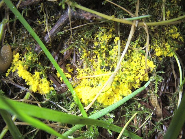
A slime mould - Fuligo septica (plasmodium)
Fuligo septica is one of the most common slime moulds; the specimen shown here is not yet mature. For mature specimens, see NS3681 : A slime mould - Fuligo septica var. flava and NS3681 : A slime mould - Fuligo septica var. flava.
The plasmodium is a mass of almost naked protoplasm (it has no cell wall, but has a cell membrane), which slowly streams over leaf litter and other material, effectively behaving like a giant amoeba, engulfing bacteria (and some other material, such as fungal spores) as it goes. My photograph shows the final part of the plasmodial stage. The following photo, by another contributor, shows a typical plasmodium, probably that of the same species, but at an earlier stage: TA0088 : Slime Mould.
Plasmodia often spread out in a fan-shaped pattern, with most of their mass concentrated at the leading edge, as is the case here: this slime mould is heading in the direction of the blades of grass at the bottom of the photo.
At the end of the plasmodial stage, when the slime mould is about to form a spore-producing fruiting body, the material begins to knot (or clump), in the manner shown in the present photograph.
 Map © Crown Copyright")
TIP: Click the map for more Large scale mapping
- Grid Square
- NS3582, 35 images (more nearby 🔍)
- Photographer
- Lairich Rig (more nearby)
- Date Taken
- Wednesday, 15 August, 2007 (more nearby)
- Submitted
- Wednesday, 13 August, 2008
- Subject Location
-
OSGB36:
 NS 351 821 [100m precision]
WGS84: 56:0.2167N 4:38.6789W - Camera Location
-
OSGB36: NS 351 821
- View Direction
- EAST (about 90 degrees)