2005
SY8580 : Coastal scenery in Worbarrow Bay, Isle of Purbeck
taken 18 years ago, near to East Lulworth, Dorset, England
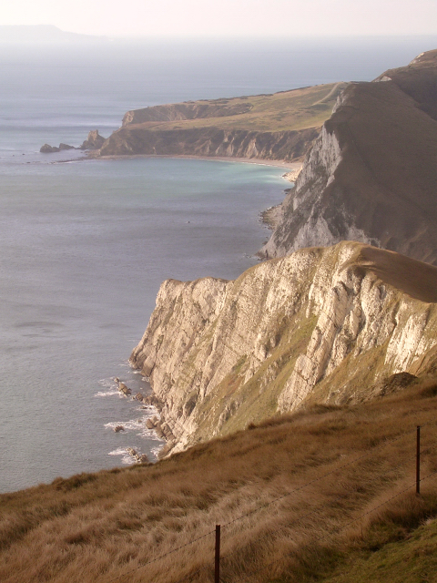
Coastal scenery in Worbarrow Bay, Isle of Purbeck
This view is looking west from the Flower's Barrow hillfort on Rings Hill. In the foreground is part of the iron-age hillfort which is slowly disappearing as the cliffs crumble into the bay below. Beyond this are the illuminated chalk cliffs at Cow Corner which form a knife-edge which drops down to Arish Mell. Beyond this, in shadow, is the eastern end of Bindon Hill on the far side of Arish Mell. To the left of this are the clear waters of Mupe Bay, with Mupe Rocks to the far left. On the horizon to the left of the picture, almost lost in the haze, is the northern end of the Isle of Portland.
 Map © Crown Copyright")
TIP: Click the map for more Large scale mapping
- Grid Square
- SY8580, 49 images (more nearby 🔍)
- Photographer
- Jim Champion (more nearby)
- Date Taken
- Tuesday, 27 December, 2005 (more nearby)
- Submitted
- Tuesday, 27 December, 2005
- Subject Location
-
OSGB36:
 SY 859 803 [100m precision]
WGS84: 50:37.3339N 2:12.0410W - Camera Location
-
OSGB36: SY 864 805
- View Direction
- West-southwest (about 247 degrees)