2008
SD7921 : Turbine tower section at Haslingden
taken 16 years ago, near to Haslingden, Lancashire, England
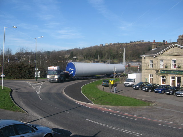
Turbine tower section at Haslingden
This 50 ton 22 metre turbine tower section enroute to Scout Moor has just left the A56 and has turned on to the B6527 Manchester Road.
The public house on the right is SD7921 : The Woolpack, Manchester Road, Haslingden
Between November 2007 and May 2008 regular tower section deliveries passed through this location which in the end made up the 26 completed wind turbines on Scout Moor.
SD8015 : Turbine Convoy passing Ramsbottom on the M66
SD7920 : Turbine Delivery Passing Through Ewood Bridge
SD7919 : Turbine tower section passing Edenfield Primary School
SD7919 : Last Turbine Tower Delivery to Scout Moor
SD8019 : Turbine Convoy passing through Bridge Mills
SD8018 : Turbine Tower Convoy on the A680
SD8118 : Nearly There.
Turbine details: Tower Height: 60m
Blade Length: 40m Total Max Height: 100m
Manufacturer: Nordex
Model: N80 Link (Archive Link )
Key Facts Link (Archive Link )
Scout Moor Wind Farm Construction Picture Gallery
Link
The public house on the right is SD7921 : The Woolpack, Manchester Road, Haslingden
Between November 2007 and May 2008 regular tower section deliveries passed through this location which in the end made up the 26 completed wind turbines on Scout Moor.
SD8015 : Turbine Convoy passing Ramsbottom on the M66
SD7920 : Turbine Delivery Passing Through Ewood Bridge
SD7919 : Turbine tower section passing Edenfield Primary School
SD7919 : Last Turbine Tower Delivery to Scout Moor
SD8019 : Turbine Convoy passing through Bridge Mills
SD8018 : Turbine Tower Convoy on the A680
SD8118 : Nearly There.
Turbine details: Tower Height: 60m
Blade Length: 40m Total Max Height: 100m
Manufacturer: Nordex
Model: N80 Link
Key Facts Link
Scout Moor Wind Farm Construction Picture Gallery
Link
 Map © Crown Copyright")
TIP: Click the map for more Large scale mapping
- Grid Square
- SD7921, 107 images (more nearby 🔍)
- Photographer
- Paul Anderson (more nearby)
- Date Taken
- Monday, 11 February, 2008 (more nearby)
- Submitted
- Wednesday, 8 October, 2008
- Subject Location
-
OSGB36:
 SD 794 219 [100m precision]
WGS84: 53:41.6150N 2:18.8069W - Camera Location
-
OSGB36: SD 794 219
- View Direction
- North-northwest (about 337 degrees)