Shared description
The Kinglake Estate, London SE17
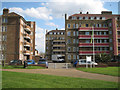
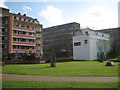
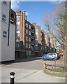
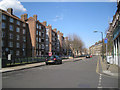
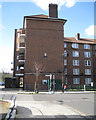
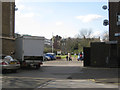
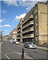
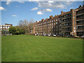
The estate comprises nine brick-built blocks of flats on each side of Kinglake Street, east of the better-known Aylesbury Estate. Kinglake Estate first appears, complete, on an OS map of 1951, suggesting that it was begun during the late 1940s among the earliest post-war public housing in London.
A map of 1851 shows most of the local streets in place but not always with their modern names. A map of 1875 shows the area consisting of small terrace houses with rear yards or gardens. It is all Newington. York Road has become the modern Bagshot Street. The main artery is Alvey Street running northwest, not the Old Kent Road to the east. On the 1895 map a school has appeared in Surrey Square and King Road has become Kinglake Street. There is little change up to 1938.
By 1951 the big church on Aldridge Street has gone. The whole area is shown as Walworth, a name earlier applied to the small neighbourhood centred on the Walworth Road. Up to 1966 there was still a great deal of terraced housing. Not until the map of 1974-5 does the Aylesbury Estate appear to the west. Surrey Square Park is shown in 1995 where there had been a small group of houses.
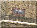
The blocks in the Kinglake Estate take the names of places in Kent. They are, on the north side from the east: Swanley House, Hadlow House, Barham House, Bethersden House, Southborough House and Tenterden House. On the south side, from the east they are: Amery House, Keston House and Faversham House. It is remarkable that while the Aylesbury Estate, built 1963-1977, is undergoing regeneration for the next few years, these monumental post-war blocks are still standing and still occupied.
A map of 1851 shows most of the local streets in place but not always with their modern names. A map of 1875 shows the area consisting of small terrace houses with rear yards or gardens. It is all Newington. York Road has become the modern Bagshot Street. The main artery is Alvey Street running northwest, not the Old Kent Road to the east. On the 1895 map a school has appeared in Surrey Square and King Road has become Kinglake Street. There is little change up to 1938.
By 1951 the big church on Aldridge Street has gone. The whole area is shown as Walworth, a name earlier applied to the small neighbourhood centred on the Walworth Road. Up to 1966 there was still a great deal of terraced housing. Not until the map of 1974-5 does the Aylesbury Estate appear to the west. Surrey Square Park is shown in 1995 where there had been a small group of houses.
The blocks in the Kinglake Estate take the names of places in Kent. They are, on the north side from the east: Swanley House, Hadlow House, Barham House, Bethersden House, Southborough House and Tenterden House. On the south side, from the east they are: Amery House, Keston House and Faversham House. It is remarkable that while the Aylesbury Estate, built 1963-1977, is undergoing regeneration for the next few years, these monumental post-war blocks are still standing and still occupied.
by Robin Stott
Created: Thu, 7 Apr 2016, Updated: Sun, 1 May 2016
11 images use this description:
Shared descriptions
This shared description
The 'Shared Description' text on this page is © copyright 2016 Robin Stott.
Shared descriptions are specifically licensed so that contributors can reuse them on their own images, without restriction.
About shared descriptions
These Shared Descriptions are common to multiple images.
For example, you can create a generic description for an object shown in a photo, and reuse the description on all photos of the object. All descriptions are public and shared between contributors, i.e. you can reuse a description created by others, just as they can use yours.
Explore images
View images using this "The Kinglake Estate, London SE17" Shared Description
View images mentioning the words [The Kinglake Estate, London SE17] anywhere in text
Links for TQ3378
This description is located in TQ3378.
Other shared descriptions
Descriptions nearby
- The Pembroke College Mission
- B214 Road
- Aylesbury Estate
- Bermondsey Spa
- Avondale Square estate
- Bricklayers Arms junction
- St Saviour's & St Olave's School
- Church of St James, Bermondsey
- North Peckham
- Southwark College, Bermondsey site
- Walworth Clinic, Walworth Road, London SE17
- The Gateway Estate, Walworth
- Leathermarket Gardens
- Manor Place development
- Bermondsey Connect2 bridge
- Guy Street Park
- London Bridge Signalbox (London Bridge Area Signalling Centre)
- Strata Tower
- Empire Square
- Elephant and Castle Underground Station
- Heygate Estate
- Southwark Park
- Tabard Street
- Burgess Park
Related descriptions
- Aylesbury Estate
By Stephen Craven. Used on 22 images
- Heygate Estate
By Oast House Archive. Used on 36 images
- Burgess Park
By Malc McDonald. Used on 127 images
- King Edward VII Memorial Park
By N Chadwick. Used on 5 images
- A corner of Walworth
By Robin Stott. Used on 3 images
- The Gateway Estate, Walworth
By Robin Stott. Used on 5 images
- Walworth Clinic, Walworth Road, London SE17
By Robin Stott. Used on 13 images
The above selections are automatic and approximate, it might not always select closely matching descriptions