Shared description
Westgate 'Castle'
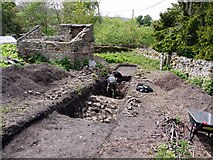
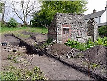
Weardale's 'Lost Castle' in Westgate was one of the most important buildings in the North Pennines from the mid C13th through until the early C17th century. It provided the 'west gate' into the Bishop of Durham's great deer park (which originally extended as far as Stanhope, but later contracted to Eastgate), and was probably used as a defensive tower house, administrative centre and hunting lodge. When ruined, most of its masonry was reused in adjacent buildings especially the adjacent school building (now an abattoir) which
dates from c1820, leaving nothing visible above ground. The site was well known to local people and with foresight of the current owner of the land, preserved from further development.
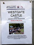
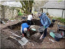
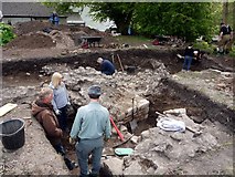
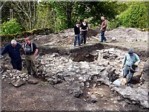
A recent geophysical survey revealed the likely location of buried walls and a preliminary community archaeology project was undertaken for a week in May 2011 to open a few trial trenches. Following public tours of the excavations on the afternoon of Saturday 14th May the site is due to be reburied awaiting funds and a proposal for a future full archaeology project.
The excavation was undertaken by the North Pennines AONB Partnership's 'Altogether Archaeology' project funded by the Heritage Lottery Fund and English Heritage directed by Durham University Archaeological Services.
North Pennines AONB Link
dates from c1820, leaving nothing visible above ground. The site was well known to local people and with foresight of the current owner of the land, preserved from further development.
A recent geophysical survey revealed the likely location of buried walls and a preliminary community archaeology project was undertaken for a week in May 2011 to open a few trial trenches. Following public tours of the excavations on the afternoon of Saturday 14th May the site is due to be reburied awaiting funds and a proposal for a future full archaeology project.
The excavation was undertaken by the North Pennines AONB Partnership's 'Altogether Archaeology' project funded by the Heritage Lottery Fund and English Heritage directed by Durham University Archaeological Services.
North Pennines AONB Link
Created: Sat, 14 May 2011, Updated: Tue, 13 Mar 2012
6 images use this description:
Shared descriptions
This shared description
The 'Shared Description' text on this page is © copyright 2011 Andrew Curtis.
Shared descriptions are specifically licensed so that contributors can reuse them on their own images, without restriction.
About shared descriptions
These Shared Descriptions are common to multiple images.
For example, you can create a generic description for an object shown in a photo, and reuse the description on all photos of the object. All descriptions are public and shared between contributors, i.e. you can reuse a description created by others, just as they can use yours.
Explore images
View images using this "Westgate 'Castle'" Shared Description
View images mentioning the words [Westgate 'Castle'] anywhere in text
Links for NY90673824
This description is located in NY90673824.
Other shared descriptions
Descriptions nearby
Related descriptions
- Methodism in Weardale
By Andrew Curtis. Used on 7 images
- Slitt Wood & West Rigg Geotrail
By Andrew Curtis. Used on 51 images
The above selections are automatic and approximate, it might not always select closely matching descriptions