Shared description
St Ninian's Isle
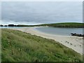
Lying off the west coast of Mainland Shetland adjacent to the village of Bigton, St Ninian's Isle is connected to the main island by a shell-sand tombolo, reckoned to be the finest (and largest active) example in the British Isles.
St Ninian's occasionally becomes a true island when tides and weather combine to inundate the tombolo, but usually it is, strictly speaking, a peninsula.
The little island has an area of approximately 178 acres (72ha) and rises to a maximum elevation of 174' (53m). According to the information board on the Bigton side of the tombolo, the coastal walk around the island is approximately 3½ miles (5.3km) long and will take about 1½ - 2 hours to complete. This board also tells us that the island was inhabited until 1775, though Wikipedia gives a date of 1796.
On 4th July 1958, a schoolboy, Douglas Coutts, who was helping visiting archaeologists, uncovered the fantastic Pictish silver "St Ninian's Isle Treasure" dating from c.800 AD see Link and Link for more details.
St Ninian's occasionally becomes a true island when tides and weather combine to inundate the tombolo, but usually it is, strictly speaking, a peninsula.
The little island has an area of approximately 178 acres (72ha) and rises to a maximum elevation of 174' (53m). According to the information board on the Bigton side of the tombolo, the coastal walk around the island is approximately 3½ miles (5.3km) long and will take about 1½ - 2 hours to complete. This board also tells us that the island was inhabited until 1775, though Wikipedia gives a date of 1796.
On 4th July 1958, a schoolboy, Douglas Coutts, who was helping visiting archaeologists, uncovered the fantastic Pictish silver "St Ninian's Isle Treasure" dating from c.800 AD see Link
and Link for more details.by Rob Farrow
Created: Wed, 7 Sep 2011, Updated: Fri, 20 Jan 2012
19 images use this description:

2026

2026

2026

2019

2018

2017

2011

2011

2011

2011

2011

2011

2011
2011

2011

2011

2011

2011

2010
Shared descriptions
This shared description
The 'Shared Description' text on this page is © copyright 2011 Rob Farrow.
Shared descriptions are specifically licensed so that contributors can reuse them on their own images, without restriction.
About shared descriptions
These Shared Descriptions are common to multiple images.
For example, you can create a generic description for an object shown in a photo, and reuse the description on all photos of the object. All descriptions are public and shared between contributors, i.e. you can reuse a description created by others, just as they can use yours.
Explore images
Log in to view extended navigation and 'Explore' links.Other shared descriptions
Search for other Shared Descriptions.
