Showing most recent first, in descending order

5 images in cluster Ashley Walk Bombing Range in SU2016

Image clustering - assigning images labels - is an automated process, based on the image title/description. It's not totally accurate, and can sometimes assign images to odd clusters

in SU2016, near Bohemia/SU2019
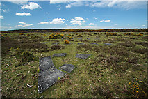
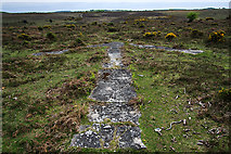
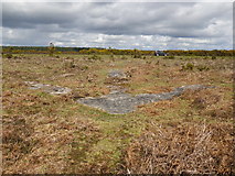

SU2016 : (17b) A tour of the WWII Ashley Walk Bombing Range - site of North Tower by Mike Searle
(17b) A tour of the WWII Ashley Walk Bombing Range - site of North Tower
When: 13 May, 2015
By: Mike Searle
SU2016 : (17a) A tour of the WWII Ashley Walk Bombing Range - site of North Tower by Mike Searle
(17a) A tour of the WWII Ashley Walk Bombing Range - site of North Tower
When: 13 May, 2015
By: Mike Searle
SU2016 : Concrete arrow on Deadmans Hill by Martin Vaughan
Concrete arrow on Deadmans Hill
When: 10 April, 2012
By: Martin Vaughan
SU2016 : Disused car park on Deadman Hill, New Forest by Jim Champion
Disused car park on Deadman Hill, New Forest
When: 13 June, 2007
By: Jim Champion
SU2016 : Disused car park above Black Gutter Bottom, New Forest by Jim Champion
Disused car park above Black Gutter Bottom, New Forest
When: 11 November, 2006
By: Jim Champion

Explore these images in the Browser or Explore matching images including in surrounding squares (if any!)


Other Automatic clusters in SU2016
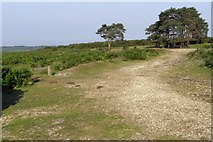
  1. Path
  2. Leaden Hall
  3. Tree
  4. Disused Car Park on Deadman Hill
  5. Ashley Walk Bombing Range
  6. B3078 Road
  7. Gravel
  8. Place
  9. Ponies and Cattle
  10. Roger Penny Way
  11. Alongside the B3078 Road on Deadman Hill
  12. Valley
  13. Ford
  14. Ditchend Brook
  15. Concrete Arrow
  16. Flowers
  17. Gorse
You are not logged in login | register