Showing most recent first, in descending order
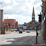
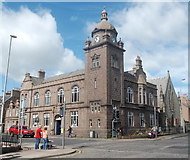
2 images in cluster Church to the Right in NK1346
Image clustering - assigning images labels - is an automated process, based on the image title/description. It's not totally accurate, and can sometimes assign images to odd clusters
in NK1346, near Peterhead/NK1346, taken Saturday, 27 June, 2015, by Bill Harrison
Explore these images in the Browser or Explore matching images including in surrounding squares (if any!)
All images  © Bill Harrison and licensed for reuse under this Creative Commons Licence
Other Automatic clusters in NK1346
- Peterhead Harbour
- Marischal Street
- Broad Street
- Queen Street
- Town House
- Proclamation Pend
- Shops
- Port Henry Harbour
- St Peter Street
- Fishing Boats
- Proclamation Pend Window
- North
- Erroll Street
- Statue of Field Marshall Keith
- Fisher Jessie
- Merchant Street
- Aberdeenshire Council Offices
- South
- Showing Position of Postbox
- Parish Church
- Businesses
- Cross Keys
- Windmill Street
- Scott's Pier
- Centre of Peterhead
- Police Station
- Peterhead Ice Company
- Ugle Street
- St Mary's Roman Catholic Church
- Estate Agents
- Flats on Longate
- Bus on Chapel Street
- Peterhead Fish Market
- Lifting Bridge
- Arbuthnot Museum and Library
- Building to a Courtyard
- Waverley Bar
- Smithy Close
- Church to the Right
- Royal Bank of Scotland
- Foreshore at Roanheads
- Gadle Braes
- Peterhead Telephone Exchange
- Muckle Kirk
- Old Parish
- Narrow Lane


