Showing most recent first, in descending order
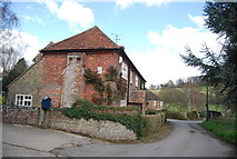
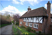
2 images in cluster Farmhouse in TR0749
Image clustering - assigning images labels - is an automated process, based on the image title/description. It's not totally accurate, and can sometimes assign images to odd clusters
in TR0749, near Crundale/TR0749, taken Wednesday, 4 April, 2012, by N Chadwick
Explore these images in the Browser or Explore matching images including in surrounding squares (if any!)
All images  © N Chadwick and licensed for reuse under this Creative Commons Licence
Other Automatic clusters in TR0749
- Lane towards Crundale
- Road to Crundale
- Field
- Stour Valley Walk
- House
- Purr Wood
- Sole Street
- Unnamed Lane
- Valley of the Great Stour
- Heads
- Near Crundale
- Farmland
- Unnamed Lane in Crundale
- Footpath to Godmersham
- Old Rectory
- Near Thornham Lodge
- Ripple Farm
- North of Crundale
- Fairisle Farm
- House on Denwood Street
- Glenwood
- Farmhouse
- Viney's Wood