Showing most recent first, in descending order
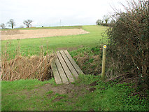
images in cluster Footbridge in TG2403
Image clustering - assigning images labels - is an automated process, based on the image title/description. It's not totally accurate, and can sometimes assign images to odd clusters
in TG2403, near Caistor St Edmund, taken Friday, 5 February, 2016, by Evelyn Simak
Explore these images in the Browser or Explore matching images including in surrounding squares (if any!)
All images  © Evelyn Simak and licensed for reuse under this Creative Commons Licence
Other Automatic clusters in TG2403
- Footpath
- Caistor St Edmund
- Broken Back Plantation
- High Ash Farm
- Permissive Path
- South of Caistor Lane
- Valley Farm Lane
- Field Boundary
- Wider View of this Location
- Planted in 2007
- Highfield Farm
- Private Bridleway
- Lane Road Sign
- Wild Flower Meadow
- Highash Farm
- Grazing
- Flowering Tree beside High Ash Lane
- Horse
- Crop
- Fields East of High Ash Lane
- Trees Growing
- Fields North of Caistor Lane
- Small Stream
- Hedge
- Boudica's Way