Showing most recent first, in descending order
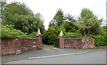
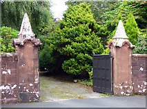
2 images in cluster Gateway at Tudor House in NS1967
Image clustering - assigning images labels - is an automated process, based on the image title/description. It's not totally accurate, and can sometimes assign images to odd clusters
in NS1967, near Skelmorlie, taken Saturday, 29 July, 2017, by Thomas Nugent
Explore these images in the Browser or Explore matching images including in surrounding squares (if any!)
All images  © Thomas Nugent and licensed for reuse under this Creative Commons Licence
Other Automatic clusters in NS1967
- Red Sandstone
- Viewed
- Skelmorlie Castle Road
- Firth of Clyde
- South
- Halketburn Road
- Lead
- Hydro Steps
- A78 Shore Road
- Red Sandstone Houses
- Bowling Club
- Looking down the Hill
- Measured Mile Marker
- Fosterland
- Annetyard Drive
- Skelmorlie Golf Club
- Sandybrae Road
- Post Office
- Paddockdyke
- Eglinton Gardens
- Montgomerie Drive
- Wemyss Bay
- Upper Skelmorlie
- Tennis Club
- Stroove House
- Long Hill
- Seton Terrace
- Halket Burn
- Reservoir
- Craig Memorial
- Probably A Waste Water Pumping Station
- Shop
- Flood Gate on the A78 in Skelmorlie
- Roots in the Rocks
- Known as Halketburn Cottage and has Associations
- Gateway at Tudor House
- Oakhill Gatepost
- Broken Land side Marker
- Chinese Restaurant is the Southernmost Occupied Building
- New Flats
- Eglinton Bar
- West of the Lane which is Closed