Showing most recent first, in descending order
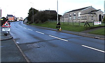
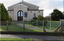
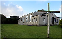
4 images in cluster Johnston Baptist Church in SM9310
Image clustering - assigning images labels - is an automated process, based on the image title/description. It's not totally accurate, and can sometimes assign images to odd clusters
in SM9310, near Johnston/SM9310, taken Thursday, 18 February, 2016, by Jaggery
Explore these images in the Browser or Explore matching images including in surrounding squares (if any!)
All images  © Jaggery and licensed for reuse under this Creative Commons Licence
Other Automatic clusters in SM9310
- Johnston Railway Station
- Sign in Johnston
- West Wales Line
- Road Bridge
- North
- St Peter's Church
- Milford Haven
- East of Johnston
- Hillcroft
- Entrance to Johnston
- Car
- South of Langford Road
- A4076 Vine Road
- Viewed across the A4076 St Peter's Road
- Area of Housing
- Path
- Greenhall Park
- Cranham Park
- Brunel Trail
- Post Office
- Right for Haverfordwest
- National Cycle Network Route
- Johnston War Memorial
- Glebelands is an Area
- Hall Court
- Pembrokeshire
- Footbridge
- Bus Stop
- Esso Filling Station
- Pond Bridge Housing Development
- Johnston County Primary School
- Glebelands Field
- Johnston Baptist Church
- Silverdale Close
- Bar
- Acorn Drive
- Speed Bumps
- Doctor's Surgery
- Help Charity Shop
- Ordnance Survey Cut Mark
- Western Power Distribution Electricity Substation