Showing most recent first, in descending order
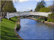
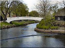
2 images in cluster Land was Marshy and Liable to Flooding in SJ9222
Image clustering - assigning images labels - is an automated process, based on the image title/description. It's not totally accurate, and can sometimes assign images to odd clusters
in SJ9222, near Stafford, taken Tuesday, 12 April, 2011, by David Dixon
Explore these images in the Browser or Explore matching images including in surrounding squares (if any!)
All images  © David Dixon and licensed for reuse under this Creative Commons Licence
Other Automatic clusters in SJ9222
- River Sow
- Lichfield Road
- Victoria Park
- Bridge Street
- Town Mill
- Picture House
- Town Centre
- Newport Road
- Tesco Extra
- White Lion
- Junction
- Stafford Baptist Church
- Mill Bank
- Bowling Green
- Riverway
- Cinema
- Apartments
- Titanic Brewery
- A34
- Walk
- Terrace
- Garden
- Old Library
- St Paul's Church
- Star Garter
- Footpath
- Tropical
- Sheds
- Jubilee
- Hough Retail Park
- Footbridge at Queensville Curve
- King Edward VI School
- Friars Terrace
- Tropical House
- Land was Marshy and Liable to Flooding
- Alstom
- Brine Baths
- Name of the Sun
- Espley's Yard
- Depot
- Grapes Music Bar