Showing most recent first, in descending order
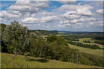
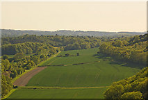
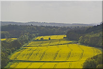
3 images in cluster Left and White Downs on the Right in TQ1249
Image clustering - assigning images labels - is an automated process, based on the image title/description. It's not totally accurate, and can sometimes assign images to odd clusters
in TQ1249, near Wotton/TQ1247, by Ian Capper
When: 30 June, 2012
When: 22 May, 2010
When: 2 May, 2009
Explore these images in the Browser or Explore matching images including in surrounding squares (if any!)
All images  © Ian Capper and licensed for reuse under this Creative Commons Licence
Other Automatic clusters in TQ1249
- North Downs Way
- Near Dorking
- Line
- Pill Box
- Great Copse
- Viewed from Denbies Hillside
- Ranmore Common
- Pillbox by Bridleway Wotton 114
- Heading
- Left and White Downs on the Right
- Spire of St Barnabas' Church
- View Eastwards
- Saw an Invasion of Painted Lady Butterflies
- Pickett's Hole
- Path along the Base of White Downs
- Old Pit
- Ancient Woodland
- Footpath Marker
- Footpath 115 Wotton
- Foot of the North Downs
- Fields of Oilseed Rape
- Clan Line Descending
- Area of Grassland
- West