Showing most recent first, in descending order
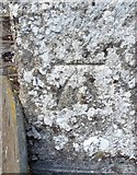
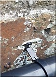
2 images in cluster Ordnance Survey Cut Mark in SX5467
Image clustering - assigning images labels - is an automated process, based on the image title/description. It's not totally accurate, and can sometimes assign images to odd clusters
in SX5467, near Meavy, taken Tuesday, 26 April, 2016, by Adrian Dust
Explore these images in the Browser or Explore matching images including in surrounding squares (if any!)
All images  © Adrian Dust and licensed for reuse under this Creative Commons Licence
Other Automatic clusters in SX5467
- St Peter's Church
- Burrator Reservoir
- Road to Burrator
- Village Green
- Royal Oak Public House
- Village Cross
- Oak Tree
- Memorial
- Princetown to Yelverton Railway
- Lych Gate
- Little
- Moorland
- Bowden's Plantation
- Quarry Car Park
- Pub in the Country which is Owned
- Parish Hall
- Ordnance Survey Cut Mark
- Near
- Meavy School
- Drake's Leat
- Yennadon