Showing most recent first, in descending order
images in cluster Path in NZ3866
Image clustering - assigning images labels - is an automated process, based on the image title/description. It's not totally accurate, and can sometimes assign images to odd clusters
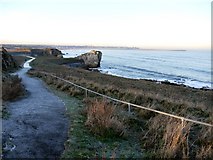
in NZ3866, near South Shields, taken Monday, 28 December, 2009, by Andrew Curtis
Explore these images in the Browser or Explore matching images including in surrounding squares (if any!)
All images  © Andrew Curtis and licensed for reuse under this Creative Commons Licence
Other Automatic clusters in NZ3866
- Trow Point
- Grahams Sands
- South Beach
- Coast
- Low Tide on the 7th May 2008
- Southern Bay
- Trow Lea
- Public House
- Promenade
- Frenchman's Bay
- Coast Road
- Gun on Trow Point
- Finish of the Great North Run
- Rock
- Near
- Looking North
- Disappearing Gun
- Trow Quarry Grahams Sands
- Sea
- View from National Cycle Route
- Waters Edge
- Coastal Path
- Old Quarry
- North across Frenchman's Bay
- Surfing Area
- Mouth of the River Tyne
- Mango's Pub
- Herd Sand
- Near Trow Point