Showing most recent first, in descending order
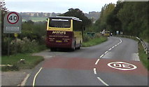
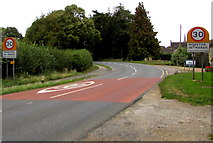
2 images in cluster Speed Limit on the A44 in SP2032
Image clustering - assigning images labels - is an automated process, based on the image title/description. It's not totally accurate, and can sometimes assign images to odd clusters
in SP2032, near Moreton-in-Marsh, taken Tuesday, 18 September, 2018, by Jaggery
Explore these images in the Browser or Explore matching images including in surrounding squares (if any!)
All images  © Jaggery and licensed for reuse under this Creative Commons Licence
Other Automatic clusters in SP2032
- High Street in Moreton-in-Marsh
- Moreton-in-Marsh Station
- Moreton in Marsh
- Grade 2 Listed
- Town
- St David's Church
- Redesdale Hall
- Bourton Road
- Church Street
- Near
- Memorial
- Parkers Lane
- Stow Road
- Tuesday Market
- 19th Century
- Cars Cars
- Moreton-in-Marsh War Memorial
- Railway Bridge
- Building Dates
- A44 Bourton Road
- Junction of the A44
- Train
- Tolls
- Edge of Moreton-in-Marsh
- Looking South
- Post Office
- Redesdale Hall 1887
- Signal Box
- Ordnance Survey Cut Mark Benchmark Described
- Curfew Tower
- Viewed in September 2018
- White Hart Royal Hotel
- Near Corner
- Name Sign
- Cotswold Stone
- Jameson Court
- Monarch's Way
- Fosseway Business Park
- East side of the A429
- Coat of Arms
- Swan Close
- Market Stalls
- Approach to Moreton-in-Marsh
- Midland Bank
- Crossing Cottage
- Set back from the East
- House Antiques
- Mann Institute
- Old Parsonage
- Doubling of the Line
- Blue Plaque
- Charity Shop
- Nameboard Shows
- Heading North
- Infant School Established 1851
- Evidence that the Walls have been Plastered
- Alongside the A429
- New Hospital
- St Davids C of E Primary School
- ex-GWR Oxford
- Information Centre