Showing most recent first, in descending order
images in cluster Spring in NZ6721
Image clustering - assigning images labels - is an automated process, based on the image title/description. It's not totally accurate, and can sometimes assign images to odd clusters
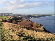
in NZ6721, near Saltburn-By-The-Sea, taken Thursday, 10 December, 2015, by Mick Garratt
Explore these images in the Browser or Explore matching images including in surrounding squares (if any!)
All images  © Mick Garratt and licensed for reuse under this Creative Commons Licence
Other Automatic clusters in NZ6721
- Saltburn by the Sea
- Cleveland Way
- Saltburn Beach
- Saltburn Scar
- Saltburn Road
- Huntcliff
- Low Tide
- Saltburn-by-the-Sea
- Hunt Cliff
- Coastguard Cottages
- England Coast Path
- Farm
- Cleveland Coast
- Ship
- Saltburn Gill
- Old Saltburn
- Heading
- Cliff-top
- Public Footpath
- Rutway
- Little Dale
- Lower Jurassic
- Cliff Edge
- Eastern end of Saltburn Sands
- Brotton
- Pipe
- Boulders
- Coastal Grazing
- Wet Sand at Low Tide