Showing most recent first, in descending order
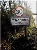
3 images in cluster Stradbroke Village Name Sign in TM2374
Image clustering - assigning images labels - is an automated process, based on the image title/description. It's not totally accurate, and can sometimes assign images to odd clusters
in TM2374, near Stradbroke, by Geographer

When: 3 March, 2015
When: 24 February, 2015
When: 24 February, 2015
Explore these images in the Browser or Explore matching images including in surrounding squares (if any!)
All images  © Geographer and licensed for reuse under this Creative Commons Licence
Other Automatic clusters in TM2374
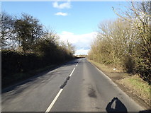
- Road through Stradbroke
- B1118 Queens Street
- Junction with the B1117 Laxfield Road
- Sign
- Near Stradbroke
- Drapers Hill
- Stradbroke Cemetery
- B1117 Church Street
- Stradbroke CEVC Primary School
- Looking
- Green
- Chapel at Stradbroke Cemetery
- House
- Neaves Lane
- Stradbroke Post Office Stradbroke Library
- B1118 Queens Road
- Stradbroke Village Name Sign
- Queens Head Public House
- Saints Church
- Shelton Hill
- Near Stradbroke CEVC Primary School
- Bridge on the B1117 Laxfield Road
- Entrance to Street Farm
- Footpath to Pixey Green
- Entering Stradbroke on the B1118 Queens Street