Showing most recent first, in descending order
images in cluster Wandlebury Country Park in TL5053
Image clustering - assigning images labels - is an automated process, based on the image title/description. It's not totally accurate, and can sometimes assign images to odd clusters
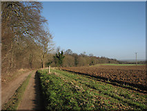
in TL5053, near Babraham, taken Monday, 4 February, 2013, by John Sutton
Explore these images in the Browser or Explore matching images including in surrounding squares (if any!)
All images  © John Sutton and licensed for reuse under this Creative Commons Licence
Other Automatic clusters in TL5053
- Edge
- Morning on the Roman Road
- Copley Hill
- Track
- Path
- Cambridge end of the Roman Road
- Gog Magog Hills
- Roman Road to the A1307
- Edge of Wandlebury Country Park
- Footpath
- Lodge Farm
- Big Fields
- North
- Woodland
- Christmas Day
- Turbines of Wadlow Wind Farm
- Leaves
- Early Spring
- Autumnal Colours
- Bright and Blustery October Morning
- Farmland
- E2 Long Distance
- Bridle Way
- Late Summer
- Plenty
- Restricted Byway
- View along the Old Roman Road
- Section of the Route
- October 2008
- North-east
- Known as Worsted or Wool Street
- Knapweed
- Highway Boundary
- Harvesting the Sugar Beet
- Countryside
- Beech Avenue
- Zoom View