Public Tags
Tag: A2·(Northern·Ireland)
Showing latest 50 of 134 images tagged with A2 (Northern Ireland) tag.
|
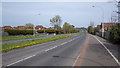
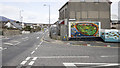
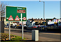
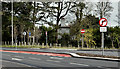
The A2, Bangor
by Rossographer geograph for square J5280 The exciting Bangor ring road (part of the long A2) looking towards the... (more)
Tags:
A2 (Northern Ireland)
place:BangorX
BangorX
Bangor (Co Down)X
type:GeographX
Ring RoadX
subject:RoadX
top:Roads, Road TransportX
top:Suburb, Urban FringeX
|
|
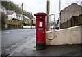
Postbox, Larne
by Rossographer geograph for square D4002 George VI pillar box (BT40 699) on the A2 Bank Road in Larne.
Tags:
road:A2X
A2X
A2 (Northern Ireland)
top:CommunicationsX
type:GeographX
George VIX
royal cipher:George VIX
postbox:George VIX
George VI Pillar BoxX
George VI PostboxX
top:Historic Sites and ArtefactsX
postbox:Pillar BoxX
Pillar BoxX
subject:PostboxX
top:Suburb, Urban FringeX
|
|
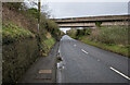
Bridge, Magheramorne
by Rossographer geograph for square J4498 The quarry bridge over the A2 at Magheramorne, connecting the quarry to the... (more)
Tags:
road:A2X
A2X
A2 (Northern Ireland)
BridgeX
Bridge Over RoadX
type:GeographX
MagheramorneX
subject:RoadX
top:Roads, Road TransportX
|
|
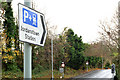
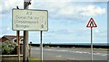
"Park and ride" sign, Jordanstown
by Albert Bridge geograph for square J3683 A sign, on the Shore Road, giving directions to Jordanstown station J3584 : Train, Jordanstown level crossing... (more)
|
|
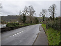
The A2 near Glynn
by Rossographer geograph for square D4000 The A2 Shore Road just outside Glynn.
|
|
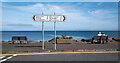
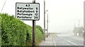
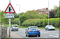
Direction signs, Ballyhalbert
by Rossographer geograph for square J6463 Direction signs on the A2 at Ballyhalbert on the Ards Peninsula.
Tags:
A2X
road:A2X
A2 (Northern Ireland)
Ards PeninsulaX
BallyhalbertX
top:CoastalX
Direction SignX
Direction SignsX
type:GeographX
subject:Road JunctionX
top:Roads, Road TransportX
Sea ViewX
|
|
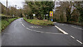
Road junction, Glynn
by Rossographer geograph for square J4199 The Rectory Road to the left and the A2 shore Road towards Glynn and Larne on the right.
Tags:
road:A2X
A2X
A2 (Northern Ireland)
type:GeographX
Road JunctionX
subject:Road JunctionX
top:Roads, Road TransportX
|
|
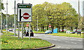
Direction sign, Holywood (May 2018)
by Albert Bridge geograph for square J3978 A direction sign, on the Belfast Road, approaching the end of the Holywood... (more)
Tags:
A2 (Northern Ireland)
Dual CarriagewayX
type:GeographX
place:HolywoodX
Road SignX
top:Roads, Road TransportX
|
|
The A2, Annalong
by Rossographer geograph for square J3719 The A2 Glasdrumman Road through Annalong with Main Street running off to the... (more)
Tags:
A2X
A2 (Northern Ireland)
AnnalongX
top:CoastalX
type:GeographX
subject:RoadX
top:Roads, Road TransportX
top:Village, Rural SettlementX
|
|
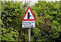
Faded and patched road sign, Millisle (July 2015)
by Albert Bridge geograph for square J5976 Back in the 1970s a decision was made to abolish the statute mile... (more)
|
|
Route confirmatory sign, Millisle (July 2015)
by Albert Bridge geograph for square J5975 A route confirmatory sign, showing four destinations along the Ards Peninsula,... (more)
|
|
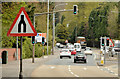
"Hospital" direction sign, Sydenham bypass, Belfast (November 2014)
by Albert Bridge for square J3776 A sign on the outward lanes of the Sydenham bypass giving directions to the... (more)
|
|
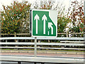
"Merging lanes" sign, Sydenham bypass, Belfast (November 2014)
by Albert Bridge for square J3776 See J3876 : Direction and lane sign, Knocknagoney/Tillysburn, Belfast (outward lanes). A sign where the three inward lanes merge to... (more)
|
|
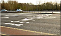
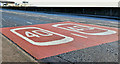
Road markings, Sydenham bypass, Tillysburn, Belfast (March 2014)
by Albert Bridge geograph for square J3876 Road markings, on the five outward lanes, approaching the Tillysburn traffic... (more)
|
|
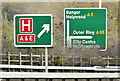
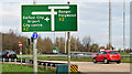
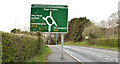
Direction signs near Bangor
by Albert Bridge geograph for square J4780 Two directions sign on the Belfast Road. The one on the left shows the route to... (more)
|
|
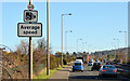
Speed camera sign, Holywood bypass
by Albert Bridge geograph for square J3979 The speed limits between Holywood and Bangor are enforced, inter alia, by the... (more)
Tags:
A2 (Northern Ireland)
BypassX
place:HolywoodX
Road SignX
top:Roads, Road TransportX
Speed LimitX
|
|
Direction sign, Holywood bypass
by Albert Bridge geograph for square J3979 A direction sign close to the station. The height restriction refers to this... (more)
|
|
"Road junction ahead" sign, Craigavad
by Albert Bridge for square J4381 A sign, on the Bangor side of the Seahill Road traffic lights, giving advance... (more)
|
|
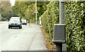
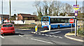
Traffic counter, Cultra
by Albert Bridge for square J4180 A traffic counter, beside the Bangor Road, between Station Road Cultra and Cultra Avenue.
Tags:
A2 (Northern Ireland)
place:CultraX
RoadX
top:Roads, Road TransportX
top:Suburb, Urban FringeX
Traffic CounterX
|
|
"Side road ahead" sign, Craigavad
by Albert Bridge geograph for square J4380 This part of the Bangor Road, which includes the Devils Elbow J4381 : The Devil's Elbow, Craigavad (1), is... (more)
|
|
Direction sign, Belfast
by Albert Bridge geograph for square J3474 A direction sign, on the Queens Bridge (Bridge End on the Google map), which... (more)
|
|
40mph road markings, Carrickfergus (January 2017)
by Albert Bridge for square J3986 40 mph markings on the outward lanes of the Belfast Road near Trooperslane.
Tags:
40mphX
A2 (Northern Ireland)
place:CarrickfergusX
type:Close LookX
subject:RoadX
RoadX
Road MarkingsX
top:Roads, Road TransportX
Speed LimitX
Speed Limit 40mphX
|
|
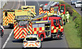
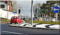
Road traffic accident, Sydenham bypass, Belfast - April 2015(3)
by Albert Bridge for square J3775 See J3775 : Road traffic accident, Sydenham bypass, Belfast - April 2015(2). The ambulance after joining the police and the Fire and Rescue Service.
|
|
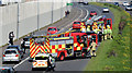
Road traffic accident, Sydenham bypass, Belfast - April 2015(1)
by Albert Bridge geograph for square J3775 A road traffic accident, on the outward lanes of the Sydenham bypass, beside the... (more)
|
|
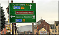
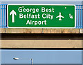
City Airport advance direction sign, Sydenham bypass, Belfast (January 2015)
by Albert Bridge for square J3775 An advance direction sign, for the entrance to the City Airport (¼ mile),... (more)
|
|
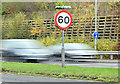
60mph speed limit sign, Belfast (December 2014)
by Albert Bridge for square J3876 In the UK the maximum speed allowed is 60 mph on single carriageways and 70mph... (more)
|
|
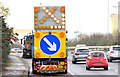
Self-propelled road sign, Sydenham bypass, Belfast (November 2014)
by Albert Bridge for square J3876 See J3775 : Self-propelled road sign, Belfast. Officially known as a portable road sign, the vehicle was... (more)
|
|
Direction sign, Tillysburn, Belfast (November 2014)
by Albert Bridge geograph for square J3876 A direction sign, on the Holywood Road, approaching the Sydenham bypass.
|
|
"Marshalls" rodding cover, Tillysburn, Belfast
by Albert Bridge for square J3876 A Marshalls rodding cover J3474 : "Marshalls" grating cover, Belfast, beside the outward lanes of the Sydenham... (more)
|
|
"End of dual carriageway" sign, Marino, Holywood
by Albert Bridge geograph for square J4179 An end of dual carriageway sign, at the Whinney Hill junction, on this dual... (more)
|
|
Roundabout sign, Ballyholme, Bangor
by Albert Bridge geograph for square J5282 A roundabout sign, approaching the Groomsport Road roundabout at Ballyholme from... (more)
|
|
The Culmore Road near Derry
by Rossographer geograph for square C4520 The Culmore Road approaching Londonderry.
|
|
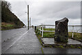
Memorial stone near Larne
by Rossographer geograph for square D4004 Stone with plaque on the A2 Antrim Coast Road just outside Larne - see... (more)
Tags:
road:A2X
A2 (Northern Ireland)
Antrim CoastX
Antrim Coast RoadX
Coast RoadX
top:CoastalX
type:GeographX
top:Historic Sites and ArtefactsX
subject:RoadX
top:Roads, Road TransportX
|
|
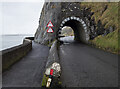
The Black Arch near Larne
by Rossographer geograph for square D3905 The Black Arch (sometimes called the Blackcave Tunnel) on the A2 Antrim Coast... (more)
Tags:
road:A2X
A2 (Northern Ireland)
Antrim CoastX
Antrim Coast RoadX
BasaltX
Coast RoadX
top:CoastalX
top:Docks, HarboursX
top:Estuary, MarineX
type:GeographX
top:PathsX
Road TunnelX
subject:TunnelX
|
|
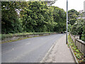
The Shore Road, Greenisland (April 2016)
by Albert Bridge geograph for square J3784 The dualled Shore Road, looking towards Belfast, south of the Station Road... (more)
|
|
Bus lane, Greenisland - April 2016(2)
by Albert Bridge geograph for square J3784 See J3784 : Bus lane, Greenisland - April 2016(1). The view from the old Shore Road. The bus lane is on the... (more)
Tags:
A2 (Northern Ireland)
subject:Bus LaneX
Bus LaneX
Greenisland (Co Antrim)X
top:Roads, Road TransportX
|
|
Bus lane, Greenisland - April 2016(1)
by Albert Bridge geograph for square J3784 See J3784 : Roundabout, Greenisland (April 2016). With the dualling of the Shore Road, on a new line, there is... (more)
Tags:
A2 (Northern Ireland)
subject:Bus LaneX
Bus LaneX
Greenisland (Co Antrim)X
top:Roads, Road TransportX
|
|
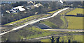
Roundabout, Greenisland (April 2016)
by Albert Bridge for square J3784 The Shore Road, rebuilt as dual carriageway between Jordanstown and Seapark,... (more)
|
|
New dual carriageway, Greenisland (March 2015)
by Albert Bridge for square J3885 The off-line section of the new Jordanstown Greenisland dual carriageway.... (more)
|
|
New dual carriageway and flyover, Greenisland (March 2015)
by Albert Bridge for square J3885 The off-line section of the new Jordanstown Greenisland dual carriageway.... (more)
|
|
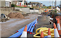
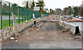
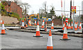
Road construction, Jordanstown/Greenisland (4)
by Albert Bridge geograph for square J3784 The Shore Road under reconstruction, looking towards Carrickfergus, between... (more)
|
|
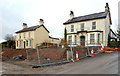
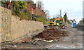
Vacant houses, Greenisland
by Albert Bridge geograph for square J3784 Two vacant houses J3784 : Vested house, Greenisland (2013-4) and J3784 : Vested house, Greenisland (2013-5), at the corner of the Shore Road... (more)
|
|
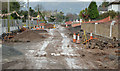
Road construction, Jordanstown/Greenisland (3)
by Albert Bridge geograph for square J3784 The Shore Road under reconstruction, looking towards Belfast, at Neills Lane.... (more)
|
|
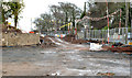
Road construction, Jordanstown/Greenisland (2)
by Albert Bridge geograph for square J3784 The Shore Road, looking towards Carrickfergus, under reconstruction at Silverstream Banks.
|
|
New culvert, Jordanstown/Greenisland
by Albert Bridge geograph for square J3784 A new culvert being built at the end of Silverstream Banks. It will carry the... (more)
|
|
Road construction, Jordanstown/Greenisland (1)
by Albert Bridge geograph for square J3784 The Shore Road, looking towards Carrickfergus, under reconstruction outside... (more)
|
|
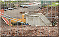
Road construction, Jordanstown (7)
by Albert Bridge geograph for square J3684 The new road under construction between Langley Hall and Belfast High School... (more)
|
|
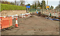
Road construction, Jordanstown (6)
by Albert Bridge geograph for square J3683 Part of the new roundabout (not yet in use), looking towards Belfast, at the... (more)
|
|
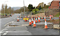
Road construction, Jordanstown (5)
by Albert Bridge geograph for square J3683 Construction of the new road at the entrance to the University of Ulster,... (more)
|
|
Road construction, Jordanstown (4)
by Albert Bridge geograph for square J3683 Part of the new roundabout (not yet in use), looking towards Carrickfergus, at... (more)
|