Geograph - photograph every grid square
About tags on Geograph
Tags
Geographical Context
Subjects
Types
Other Prefixes
Public Tags
Related Tags
|
Coverage Map
Tag:
B4149·Jockey·Road
Other tags:
place:
B4149 Jockey Road
Showing images tagged with
B4149 Jockey Road
tag.
View all tagged images
-
In Browser
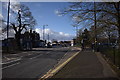
Jockey Road west end - New Oscott, Birmingham
by
Martin Richard Phelan
geograph for square
SP0994
Looking towards the western end of Jockey Road at New Oscott from a point level... (
more
)
Tags:
A4041 Queslett Road
X
A452 Chester Road North
X
B4149 Jockey Road
place:
Birmingham
X
top:
Business, Retail, Services
X
subject:
Crossroad
X
type:
Geograph
X
Homebase Superstore
X
place:
Kingstanding Circle
X
top:
Lowlands
X
place:
New Oscott
X
area:
North Birmingham
X
top:
Public Buildings and Spaces
X
place:
Queslett Roundabout
X
top:
Roads, Road Transport
X
top:
Sport, Leisure
X
top:
Suburb, Urban Fringe
X
area:
West Midlands
X
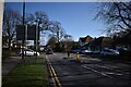
Jockey Road leading eastwards - Birmingham, West Midlands
by
Martin Richard Phelan
geograph for square
SP0994
Behind the camera the junction of the B4149 Jockey Road with the A452 Chester... (
more
)
Tags:
place:
A452 Chester Road North
X
place:
B4149 Jockey Road
place:
Birmingham
X
top:
Business, Retail, Services
X
type:
Geograph
X
top:
Health and Social Services
X
place:
Homebase Superstore
X
place:
Jockey Road Medical Centre
X
top:
Lowlands
X
place:
New Oscott
X
top:
Public Buildings and Spaces
X
subject:
Road
X
top:
Roads, Road Transport
X
top:
Suburb, Urban Fringe
X
place:
Sutton Coldfield
X
place:
Tesco Superstore
X
area:
West Midlands
X
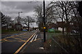
Jockey Road east - New Oscott, Birmingham
by
Martin Richard Phelan
geograph for square
SP0994
A view taken looking eastwards along Jockey Road. The entrance to the Homebase... (
more
)
Tags:
A452 Chester Road North
X
A453 Jockey Road
X
A5127 Birmingham Road
X
B4149 Jockey Road
place:
Birmingham
X
top:
Business, Retail, Services
X
College Road
X
type:
Geograph
X
place:
Homebase Superstore
X
top:
Lowlands
X
area:
North Birmingham
X
top:
Paths
X
subject:
Road
X
top:
Roads, Road Transport
X
top:
Suburb, Urban Fringe
X
place:
Sutton Coldfield
X
Tesco Store
X
area:
West Midlands
X
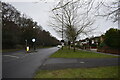
A452 south-east - Sutton Coldfield, West Midlands
by
Martin Richard Phelan
geograph for square
SP0896
Looking south-east along the A452 Chester Road North. The belt of trees on the... (
more
)
Tags:
A452 Chester Road North
X
B4149 Jockey Road
type:
Geograph
X
top:
Lowlands
X
place:
New Oscott
X
subject:
Road
X
top:
Roads, Road Transport
X
top:
Suburb, Urban Fringe
X
place:
Sutton Coldfield
X
area:
West Midlands
X
View more in the Image Search
or
in Browser
View images matching 'B4149 Jockey Road' anywhere
in
the tags
Don't click these:
PotMel 1
PotMel 2
☰
Home
View
Search
Marked Images
Maps
Browser
Explore
Showcase
New Images
Collections
Interact
Games
Discussions
Blog
Contributors
Submit
Statistics
Leaderboards
General
FAQ
Help Pages
Sitemap
Contact Us
Support Us
sponsored by
🔍
What to search:
Photos
Enter keywords or a location/postcode to search nearby images
Enter a Grid Reference
Placenames
Collections
Website Pages
Everything
Others:
Advanced Search
|
Image Browser
Or:
Coverage Map
|
Searchable Map
You are not logged in
login
|
register