Public Tags
Tag: Balmeanach
Other tags: near:Balmeanach
place:Balmeanach
Showing images tagged with Balmeanach tag.
|
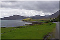
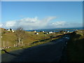
Balmeanach
by Ian Taylor geograph for square NG5234 Looking south over Balmeanach Bay, to the headland Tòrr Mòr (in the centre).... (more)
Tags:
Balmeanach
BayX
top:CoastalX
type:GeographX
subject:HamletX
Red CuillinX
top:Village, Rural SettlementX
|
|
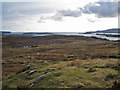
South west from Beinn Bheag
by Richard Dorrell geograph for square NG3243 A view over the moorland above the sparsely inhabited crofting township of... (more)
Tags:
place:Balmeanach
Heather MoorlandX
HillsideX
place:Isle of SkyeX
bucket:LandscapeX
top:MoorlandX
|
|
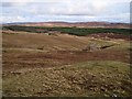
Hillside above Balmeanach
by Richard Dorrell geograph for square NG3243 The heather moorland hill is named Beinn Bheag. The land is grazed by a thin... (more)
|
|
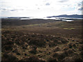
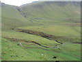
South western slopes of An Clèireach
by Richard Dorrell geograph for square NG3344 Below the heather moorland hillside, buildings in Balmeanach can be seen. The... (more)
|
|
Minor road at Balmeanach
by Dave Fergusson geograph for square NG4668 Looking towards Staffin Island.
|
|
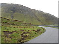
The B8035 at Balmeanach
by M J Richardson geograph for square NM4533 Tags:
road:B8035X
Balmeanach
top:GrasslandX
place:GribunX
place:Isle of MullX
top:MoorlandX
top:Roads, Road TransportX
top:Rocks, Scree, CliffsX
top:UplandsX
|
|
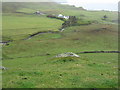
Farm at Balmeanach
by M J Richardson for square NM4433 Looking over the valley of the Allt na Teangaidh.
Tags:
Balmeanach
top:CoastalX
top:Estuary, MarineX
top:Farm, Fishery, Market GardeningX
top:GrasslandX
place:GribunX
place:Isle of MullX
PastureX
top:Rivers, Streams, DrainageX
|
|
Balmeanach and Eilean Dubh Cruinn
by M J Richardson for square NM4433 Looking across from the heights of the B8035 as it descends by the Allt na Teangaidh.
Tags:
Balmeanach
top:CoastalX
top:Estuary, MarineX
top:Farm, Fishery, Market GardeningX
top:GrasslandX
place:GribunX
place:Isle of MullX
top:LowlandsX
top:Rivers, Streams, DrainageX
|
|
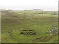
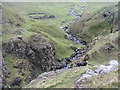
Allt na Teangaidh
by M J Richardson geograph for square NM4532 Looking down to the sheep wash complex near Balmeanach. A steep drop - the... (more)
Tags:
Balmeanach
top:Farm, Fishery, Market GardeningX
top:GrasslandX
place:GribunX
place:Isle of MullX
top:Rivers, Streams, DrainageX
top:Rocks, Scree, CliffsX
Sheep WashX
|
|
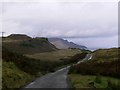
The Braes Road
by Hilmar Ilgenfritz geograph for square NG5234 Taken from B883 above Balmeanach. View along the road cutting through the... (more)
Tags:
near:Balmeanach
place:Cnoc MorX
top:CoastalX
top:Estuary, MarineX
top:GrasslandX
top:Roads, Road TransportX
near:Sound of RaasayX
place:The BraesX
top:UplandsX
|
|
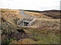
New bridge over the Allt Bhaile Mheadhonaich
by Richard Dorrell geograph for square NG3243 The bridge was rebuilt and widened in 2008 when the road was about to be used by... (more)
Tags:
place:Balmeanach
BridgeX
place:Isle of SkyeX
top:Rivers, Streams, DrainageX
top:Roads, Road TransportX
|
|
Pasture by the Allt na Teangaidh
by M J Richardson geograph for square NM4533 With the cliffs of Creag a Ghaill above to the right.
Tags:
Balmeanach
top:Farm, Fishery, Market GardeningX
top:GrasslandX
place:GribunX
place:Isle of MullX
PastureX
top:Rivers, Streams, DrainageX
top:Rocks, Scree, CliffsX
top:UplandsX
|