Public Tags
Tag: Brightlands·Road
Other tags: road:Brightlands Road
Showing images tagged with Brightlands Road tag.
|
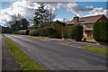
Brightlands Road
by Ian Capper geograph for square TQ2651 The 1871 large scale map of Reigate shows Brightlands Road as a cut between Wray... (more)
Tags:
Brightlands Road
person:Francis FrithX
top:Housing, DwellingsX
place:ReigateX
top:Suburb, Urban FringeX
|
|
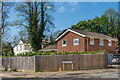
45 Wray Park Road
by Ian Capper geograph for square TQ2650 House on the corner of Wray Park Road and Brightlands Road, with an address in... (more)
Tags:
road:Brightlands Road
type:GeographX
top:Housing, DwellingsX
place:ReigateX
top:Suburb, Urban FringeX
road:Wray Park RoadX
|
|
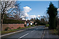
Fairford Close
by Ian Capper geograph for square TQ2651 1980s cul de sac off Brightlands Road.
Tags:
Brightlands Road
Fairford CloseX
top:Housing, DwellingsX
place:ReigateX
top:Suburb, Urban FringeX
|