Geograph - photograph every grid square
About tags on Geograph
Tags
Geographical Context
Subjects
Types
Other Prefixes
Public Tags
Related Tags
|
Coverage Map
Tag:
Bristol·Blitz
Showing images tagged with
Bristol Blitz
tag.
View all tagged images
-
In Browser
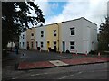
Terraced housing, Philip Street
by
S
geograph for square
ST5971
This terraced row of houses on Phillip Street were built in the 1860s. A public... (
more
)
Tags:
period:
1860s
period:
1870s
date:
1871
period:
1960s
date:
1968
place:
Bedminster
Bedminster
Bombing
place:
Bristol
county:
Bristol
Bristol Blitz
Bristol Brewery Georges & Co
top:
City, Town Centre
Demolition
type:
Geograph
Houses
subject:
Houses
top:
Housing, Dwellings
Industrial
Industrial Units
top:
Industry
Phillip Street
former:
Pub
Pub
Public House
former:
Public House
Road
Spring Tavern
Street
top:
Suburb, Urban Fringe
Terrace
housing:
Terrace
housing:
Terraced
Terraced
Terraced Houses
Terraced Housing
Whitehouse Lane
World War II
Yard off Phillip Street, Bedminster
by
S
geograph for square
ST5871
Until 1960, the yard was the site of 7 terraced houses, which were built around... (
more
)
Tags:
period:
1860s
date:
1960
period:
1960s
Bedminster
place:
Bedminster
Bombing
place:
Bristol
county:
Bristol
Bristol Blitz
BV Studios
top:
City, Town Centre
Demolition
type:
Geograph
top:
Industry
Studios
building type:
Studios
top:
Suburb, Urban Fringe
former:
Terraced Housing
World War II
subject:
Yard
Yard
View more in the Image Search
or
in Browser
View images matching 'Bristol Blitz' anywhere
in
the tags
Don't click these:
PotMel 1
PotMel 2
☰
Home
View
Search
Marked Images
Maps
Browser
Explore
Showcase
New Images
Collections
Interact
Games
Discussions
Blog
Contributors
Submit
Statistics
Leaderboards
General
FAQ
Help Pages
Sitemap
Contact Us
Support Us
sponsored by
🔍︎
What to search:
Photos
Enter keywords or a location/postcode to search nearby images
Enter a Grid Reference
Placenames
Collections
Website Pages
Everything
Others:
Advanced Search
|
Image Browser
Or:
Coverage Map
|
Searchable Map
You are not logged in
|
login
|
register