Public Tags
Tag: Chagford
Showing images tagged with Chagford tag.
|
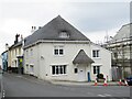
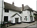
The Bishop's House, Chagford
by Alan Hunt geograph for square SX7087 The Bishop's House in Lower Street was used by the Bishops of Exeter when... (more)
|
|
Valley View, Chagford
by Alan Hunt geograph for square SX7087 An access road off Valley View in Chagford.
|
|
Two Moors Way, Chagford
by Alan Hunt geograph for square SX6987 The Two Moors Way running north of the River Teign near Chagford Bridge.
|
|
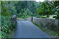
Chagford Bridge
by Alan Hunt geograph for square SX6987 The old stone bridge over the River Teign near Chagford.
|
|
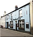
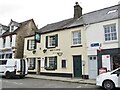
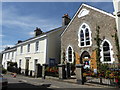
Chagford Inn
by Colin Smith geograph for square SX7087 Historic inn on Mill Street in central Chagford.
Link
Tags:
top:Business, Retail, ServicesX
place:Chagford
type:GeographX
subject:InnX
top:Village, Rural SettlementX
|
|
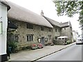
Chagford - Endecott House
by Colin Smith geograph for square SX7087 16th century Endecott House was named after a Chagford emigrant, a 17th century... (more)
Tags:
place:Chagford
type:GeographX
subject:Historic BuildingX
top:Historic Sites and ArtefactsX
top:Village, Rural SettlementX
|
|
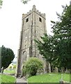
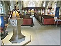
Chagford - St Michael's Church
by Colin Smith geograph for square SX7087 St Michael the Archangel is Chagford's venerable parish church. It dates... (more)
Tags:
place:Chagford
subject:ChurchX
type:GeographX
top:Historic Sites and ArtefactsX
top:Religious SitesX
St Michaels ChurchX
|
|
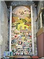
Chagford Church - Tapestry
by Colin Smith for square SX7087 Inside St Michael's, the venerable parish church, is this colourful... (more)
Tags:
subject:ArtX
place:Chagford
top:Historic Sites and ArtefactsX
type:InsideX
top:Religious SitesX
St Michaels ChurchX
TapestryX
|
|
Chagford - Thatched House
by Colin Smith geograph for square SX7087 Eyecatching thatch at the corner of Mill Street and The Square.
Link
|
|
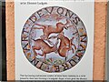
Chagford - Three Hares
by Colin Smith for square SX7087 Art shop on The Square depicting the "Tinners Rabbits", an old symbol... (more)
Tags:
subject:AdvertisementX
top:Business, Retail, ServicesX
place:Chagford
type:Close LookX
Three HaresX
|
|
Chagford - Three Hares
by Colin Smith for square SX7087 Art shop on The Square depicting the "Tinners Rabbits", an old symbol... (more)
Tags:
subject:AdvertisementX
top:Business, Retail, ServicesX
place:Chagford
type:Close LookX
Three HaresX
|
|
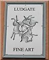
Chagford - Three Hares Gallery
by Colin Smith geograph for square SX7087 Art shop on The Square. It takes its name from the "Tinners Rabbits",... (more)
|
|
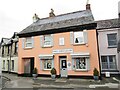
Chagford - High Street
by Colin Smith geograph for square SX7087 Green Man Cafe & Cakes caters for locals and visitors to this popular... (more)
|
|
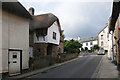
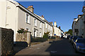
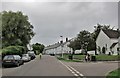
Lower Street, Chagford
by Alan Hunt geograph for square SX7087 Looking southwest towards the village centre.
|
|
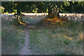
Evening sunlight, Two Moors Way
by Alan Hunt geograph for square SX6987 Evening sunlight on the Two Moors Way along the River Teign east of Chagford Bridge.
|
|
View from the Two Moors Way
by Alan Hunt geograph for square SX6987 Looking across the fields from the Two Moors Way towards the houses near Chagford Bridge.
|
|
Mill Street, Chagford
by Alan Hunt geograph for square SX6987 Looking east towards the town square.
|
|
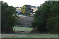
Near Chagford
by Alan Hunt geograph for square SX6988 An oak illuminated by the evening sun on farmland near the old wool mill on the... (more)
|
|
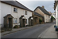
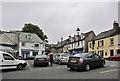
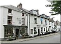
The Square, Chagford
by Richard Dorrell geograph for square SX7087 Traffic congestion is a common sight in this busy village, where road widths are... (more)
|
|
The Square, Chagford
by Richard Dorrell geograph for square SX7087 The post office business on the left, together with attached four-bedroom house,... (more)
Tags:
place:Chagford
For SaleX
Parking SpacesX
Post OfficeX
subject:StreetX
top:Village, Rural SettlementX
|
|
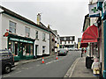
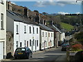
Lower Street, Chagford
by Richard Dorrell geograph for square SX7087 The junction on the right is into a residential cul-de-sac named Lamb Park
|
|
Chagford, New Street
by Chris Allen geograph for square SX7087 |
|
Chagford - Ring o' Bells
by Colin Smith geograph for square SX7087 Historic inn, facing The Square, and dating back to the 16th Century.... (more)
Tags:
top:Business, Retail, ServicesX
place:Chagford
type:GeographX
top:Historic Sites and ArtefactsX
subject:InnX
|

|
Chagford - Otter
by Colin Smith for square SX6987 Floral decorated otter model on Mill Street.
|
|
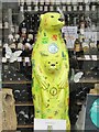
Chagford - Otter
by Colin Smith for square SX7087 Model otter in a window display, decorated to celebrate Dartmoor letter boxes.
Tags:
place:Chagford
type:Close LookX
Dartmoor LetterboxX
top:Historic Sites and ArtefactsX
subject:ModelX
model:OtterX
|
|
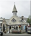
Chagford - Market House
by Colin Smith geograph for square SX7087 The granite octagonal Market house stands on The Square. Built 1862 on site of... (more)
Tags:
place:Chagford
type:GeographX
subject:Historic BuildingX
top:Historic Sites and ArtefactsX
Market HouseX
Octagonal BuildingX
top:Village, Rural SettlementX
|
|
Chagford - High Street
by Colin Smith geograph for square SX7087 Amy's Flowers and The Globe Inn sit opposite the churchyard.
Link
Tags:
top:Business, Retail, ServicesX
place:Chagford
Flower ShopX
type:GeographX
Globe InnX
High StreetX
subject:StreetX
top:Village, Rural SettlementX
|
|
Chagford - St Michael's Church
by Colin Smith for square SX7087 Inside St Michael's, the venerable parish church, is the 1857 granite font.... (more)
Tags:
place:Chagford
subject:Church InteriorX
FontX
top:Historic Sites and ArtefactsX
type:InsideX
top:Religious SitesX
St Michaels ChurchX
|
|
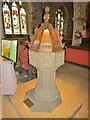
Chagford Church - Font
by Colin Smith for square SX7087 Inside St Michael's, the venerable parish church, is the 1857 granite font.... (more)
Tags:
place:Chagford
subject:FontX
top:Historic Sites and ArtefactsX
type:InsideX
top:Religious SitesX
St Michaels ChurchX
|
|
Mill Street and former chapel, Chagford
by Chris Allen geograph for square SX6987 The former chapel is now Helpful Holidays.
|
|
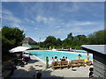
Open air swimming pool Chagford
by Chris Allen geograph for square SX7088 The former Rushford Mill is seen beyond and the pool was originally filled from... (more)
Tags:
place:Chagford
county:DevonX
Former Water MillX
type:GeographX
Open Air Swimming PoolX
top:Sport, LeisureX
subject:Swimming PoolX
top:Village, Rural SettlementX
|
|
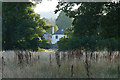
Chagford Wool Mill
by Alan Hunt geograph for square SX6987 The old wool mill on the River Teign now converted to a hotel.
|
|
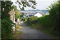
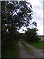
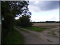
Footpath to Gromford Lane & entrance to Chagford
by Geographer geograph for square TM3958 Off The B1069 Church Road
Snape footpath no.3 leading to Snape footpath no.1
Tags:
B1069X
Chagford
Church RoadX
EntranceX
FootpathX
near:GromfordX
Gromford LaneX
House Driveway EntranceX
House EntranceX
subject:PathX
top:PathsX
at:SnapeX
off:The B1069 Church RoadX
|
|
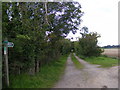
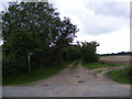
Footpath to Gromford Lane & entrance to Chagford
by Geographer geograph for square TM3958 Off The B1069 Church Road
Snape footpath no.3 leading to Snape footpath no.1
|
|
Footpath to Gromford Lane & entrance to Chagford
by Geographer geograph for square TM3958 Off The B1069 Church Road
Snape footpath no.3 leading to Snape footpath no.1
Tags:
B1069X
Chagford
Church RoadX
EntranceX
FootpathX
near:GromfordX
Gromford LaneX
House Driveway EntranceX
House EntranceX
top:Housing, DwellingsX
subject:PathX
top:PathsX
top:Roads, Road TransportX
at:SnapeX
off:The B1069 Church RoadX
|
|
Rushford Mill
by Chris Allen geograph for square SX7088 Former water mill photographed from a public footpath across Rushford Mill Farm.
Tags:
place:Chagford
top:Farm, Fishery, Market GardeningX
Former Water MillX
type:GeographX
top:PathsX
|
|
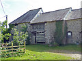
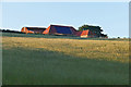
Barns, Rushford Mill Farm
by Alan Hunt geograph for square SX7088 Barns near Rushford Mill Farm illuminated by the late evening sun.
|
|
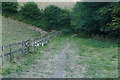
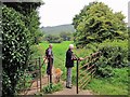
Gate onto Padley Common
by Richard Dorrell geograph for square SX6987 This entrance to the common is from close to Manor Road.
|