
|
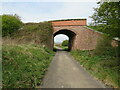
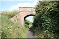
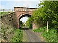
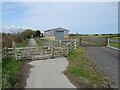
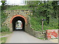
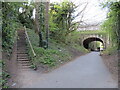
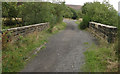
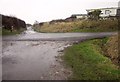
Bridge over the Cinder Track at Stainsacre
by Jeff Buck
geograph for square NZ9108
Bridge carrying Summerfield Lane over the Cinder Track at Stainsacre.
The... (more)
|
|
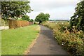
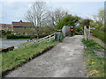
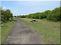
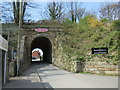
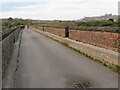
The Cinder Track at Stainsacre
by Jeff Buck
geograph for square NZ9108
Looking northwest along the Cinder Track at Stainsacre.
The Cinder Track,... (more)
|

|
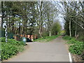
The Cinder Track between Larpool Wood & Cock Mill Wood
by Jeff Buck
geograph for square NZ9008
Heading southeast along the Cinder Track between Larpool Wood (on the left) and... (more)
|
|
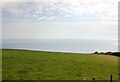
View towards the North Sea from the Cinder Track
by Jeff Buck
geograph for square NZ9507
Looking northeast from the Cinder Track.
The Cinder Track, also known as the... (more)
|

|
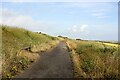
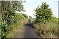
The Cinder Track near Rain Dale
by Jeff Buck
geograph for square NZ9507
Heading northwest along the Cinder Track near Rain Dale.
The Cinder Track,... (more)
|
|
Towards Hawsker Bottoms on the Cinder Track
by Jeff Buck
geograph for square NZ9407
Heading northwest towards Hawsker Bottoms on the Cinder Track.
The Cinder... (more)
|
|
The Cinder Track at Hawsker Railway Station
by Jeff Buck
geograph for square NZ9208
The Cinder Track, also known as the "Scarborough to Whitby Rail Trail"... (more)
|

|
The Cinder Track
by Jeff Buck
geograph for square NZ9009
The Cinder Track, also known as the "Scarborough to Whitby Rail Trail"... (more)
|
|
The Cinder Track on Larpool Viaduct
by Jeff Buck
geograph for square NZ8909
The Cinder Track, also known as the "Scarborough to Whitby Rail Trail"... (more)
|
|
Cinder Track near Whitby
by Malc McDonald
geograph for square NZ8909
A view along the Cinder Track, a walking and cycling trail which follows the... (more)
|
|
Cinder Track at Hawsker
by Malc McDonald
geograph for square NZ9208
The Cinder Track is a walking and cycling trail which follows the route of a... (more)
|
|
Cinder Track near Hawsker
by Malc McDonald
geograph for square NZ9208
A view along the Cinder Track, a walking and cycling trail which follows the... (more)
|
|
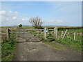
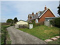
Cinder Track near Stainsacre
by Malc McDonald
geograph for square NZ9108
A view along the Cinder Track, a walking and cycling trail which follows the... (more)
|
|
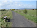
Cinder Track, Stainsacre
by Malc McDonald
geograph for square NZ9108
A view of the Cinder Track, a walking and cycling trail which follows the route... (more)
|
|
Cinder Track, Whitby
by Malc McDonald
geograph for square NZ8910
The Cinder Track path follows the route of a dismantled railway between... (more)
|

|
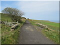
Dropping down to Robin Hood's Bay
by Jeff Buck
geograph for square NZ9506
It's downhill now all the way to Robin Hood's Bay on the Cinder Track.... (more)
|
|
The Cinder Track near Hawsker Bottoms
by Jeff Buck
geograph for square NZ9307
The Cinder Track, also known as the "Scarborough to Whitby Rail Trail"... (more)
|
|
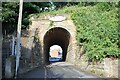
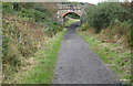
The Cinder Track at High Hawsker
by Jeff Buck
geograph for square NZ9207
The old railway bridge carries a footpath which leads from High Hawsker to Gnipe... (more)
|
|
The old track bed at Hawsker Railway Station
by Jeff Buck
geograph for square NZ9208
The Cinder Track, also known as the "Scarborough to Whitby Rail Trail"... (more)
|
|
Cinder Track near Whitby
by Malc McDonald
geograph for square NZ8909
The Cinder Track follows the route of a former railway between Whitby and... (more)
|
|
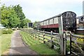
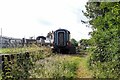
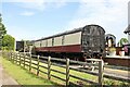
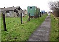
Old Railway Carriages at Hawsker
by Jeff Buck
geograph for square NZ9208
The Cinder Track, also known as the "Scarborough to Whitby Rail Trail"... (more)
|
|
Cinder Track near Hawsker
by Malc McDonald
geograph for square NZ9407
The Cinder Track is a walking and cycling trail linking Scarborough with Whitby,... (more)
|
|
Cinder Track near Hawsker
by Malc McDonald
geograph for square NZ9307
The Cinder Track is a walking and cycling trail linking Scarborough with Whitby,... (more)
|
|
Cinder Track near Hawsker
by Malc McDonald
geograph for square NZ9307
The Cinder Track is a walking and cycling trail linking Scarborough with Whitby,... (more)
|
|
Cinder Track near Hawsker
by Malc McDonald
geograph for square NZ9207
The Cinder Track is a walking and cycling trail linking Scarborough with Whitby,... (more)
|
|
Cinder Track, Hawsker, near Whitby
by Malc McDonald
geograph for square NZ9207
The Cinder Track is a walking and cycling trail linking Scarborough with Whitby,... (more)
|
|
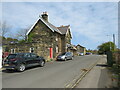
Cinder Track and former railway station, Hawsker
by Malc McDonald
geograph for square NZ9208
The Cinder Track is a walking and cycling trail linking Scarborough with Whitby,... (more)
|
|
Cinder Track, Hawsker
by Malc McDonald
geograph for square NZ9208
The Cinder Track is a walking and cycling trail linking Scarborough with Whitby,... (more)
|
|
Cinder Track near Whitby
by Malc McDonald
geograph for square NZ8909
A view along the Cinder Track, a walking and cycling trail which follows the... (more)
|
|
Arch bridge. Whitby
by Malc McDonald
geograph for square NZ8910
This arch bridge used to carry a railway through Whitby. The line closed in... (more)
|
|
Cinder Track, Whitby
by Malc McDonald
geograph for square NZ8910
This arch used to pass beneath a railway line linking Scarborough with Whitby... (more)
|
|
The Start (or end) of the Cinder Track at Whitby
by Jeff Buck
for square NZ8910
The bridge near Southend Gardens in Whitby marks the beginning (or probably the... (more)
|
|
Former railway junction, Whitby
by Malc McDonald
geograph for square NZ8910
The site of Prospect Hill junction in Whitby. The path to the right is the... (more)
|
|
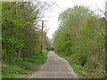
Former railway path, Whitby
by Malc McDonald
geograph for square NZ8910
This path, on the route of a former railway line, forms part of the Cinder Track... (more)
|
|
Larpool Viaduct, near Whitby
by Malc McDonald
geograph for square NZ8909
Larpool viaduct, built to carry a railway line into Whitby, now forms part of... (more)
|
|
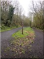
Fork on the Cinder Track
by Derek Harper
geograph for square NZ8910
The Cinder Track keeps left to cross the Esk on a viaduct, while the right fork... (more)
|
|
Bridge over the cinder track
by Pauline E
geograph for square NZ9701
Remains of the dismantled Scarborough - Whitby railway. The track ballast was... (more)
|
|
Old Railway Cinder Track
by Pauline E
geograph for square NZ9701
Remains of the dismantled Scarborough - Whitby railway. The track ballast was... (more)
|
|
The Cinder Track at Robin Hood's Bay
by Jeff Buck
geograph for square NZ9405
Heading west along the Cinder Track next to the now closed Robin Hood's Bay... (more)
|
|
Cinder Track near Robin Hood's Bay
by Malc McDonald
geograph for square NZ9407
The Cinder Track is a walking and cycling trail linking Scarborough with Whitby,... (more)
|
|
Former railway station, Robin Hood's Bay
by Malc McDonald
geograph for square NZ9405
The building in the foreground is the former railway station at Robin... (more)
|
|
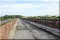
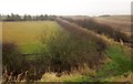
Cinder Track at Bottom House Lane
by Derek Harper
geograph for square NZ9407
The parapets of the bridge carrying the Cinder Track, following the former... (more)
|
|
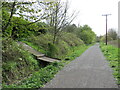
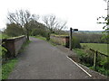
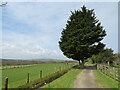
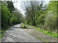
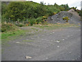
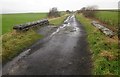
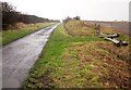
Track by the Cinder Track
by Derek Harper
geograph for square NZ9307
|
|
Cinder Track near Hawsker
by Derek Harper
geograph for square NZ9207
The cycle track along the former railway line approaches the A171 crossing shown... (more)
|
|
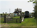
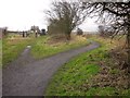
Cinder Track at Hawsker Station
by Derek Harper
geograph for square NZ9208
The cycle track swings to the right as it reaches the former station (see... (more)
|
|
Stone parapets along the dismantled railway line
by Pauline E
geograph for square NZ9701
Remains of the dismantled Scarborough - Whitby railway. The track ballast was... (more)
|
|
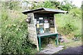
Jo's Tuck Shop on the Cinder Track at High Hawsker
by Jeff Buck
for square NZ9207
Jo's advice is to eat cake and enjoy life. Also skinny people are easy to... (more)
|
|
Mount Pleasant North, Robin Hood's Bay
by Malc McDonald
geograph for square NZ9505
Mount Pleasant North, in the village of Robin Hood's Bay on the Yorkshire... (more)
|
|
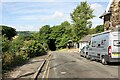
Cinder Track in the rain
by Derek Harper
geograph for square NZ9407
And boy, is it raining. On the right, old sleepers discourage entry to a field.
|
|
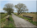
An argument with Wainwright
by Derek Harper
geograph for square NZ9307
The Cinder Track, following the former railway line from Whitby to Scarborough,... (more)
|