Public Tags
Tag: Col
Showing latest 50 of 468 images tagged with Col tag.
|
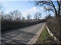
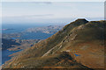
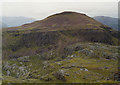
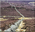
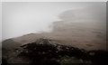
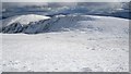
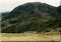
The Abberley Col
by Richard Webb geograph for square SO7074 The B4202 crosses a deep railway cutting by an embankment. There used to be a... (more)
|
|
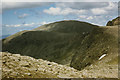
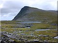
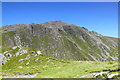
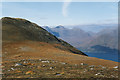
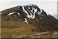
The col at the head of Gleann Cailliche
by Nigel Brown geograph for square NN3541 Category: Col The col links the Beinn Achaladair and Beinn Mhanach ranges, and provides a... (more)
|
|
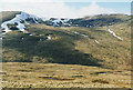
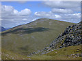
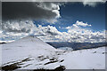
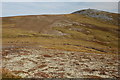
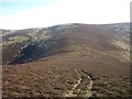
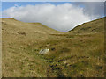
The col under Ruadh Stac Mòr
by Nigel Brown geograph for square NH0175 Category: Col The path from the east finishes on the col about here, quite a complex and stony... (more)
|
|
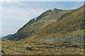
The col west of Sail Gharbh
by Nigel Brown geograph for square NC2028 Category: Col Taken from a small bump just before the col, with Sail Gharbh rising beyond.
|
|
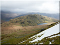
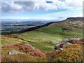
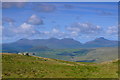
The col on Beinn Damh
by Nigel Brown geograph for square NG8751 Category: Col Looking down on the mainly flat col on Beinn Damh, which effectively separates... (more)
|
|
Col between Cairn Lochan and Stob Coire an t-Sneachda
by Nigel Brown geograph for square NH9902 Category: Col This col lies at the head of Coire Domhain; a steep path drops from here into... (more)
|
|
Col on Stob Coire Sgriodain
by Nigel Brown geograph for square NN3574 Category: Col Between the summit and the south top lies this pleasant grassy col. Due east of... (more)
|
|
The col of Meall nan Gobhar
by Nigel Brown geograph for square NN1049 Category: Col The shallow col between Meall nan Gobhar and the main massif of Beinn... (more)
|
|
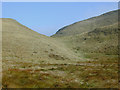
View across the col
by Nigel Brown geograph for square NH0175 Category: Col The col is surprisingly complex; a route by the right hand edge of the picture... (more)
|
|
The col, with Meall nan Ceapraichean beyond
by Nigel Brown geograph for square NH2681 Category: Col The col mixes moss, stones and several small lochans over an extended, mainly... (more)
|
|
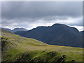
Broad col between Red Pike and High Stile
by Trevor Littlewood geograph for square NY1615 The drop between Red Pike (Buttermere) and High Stile is slight and the col... (more)
|
|
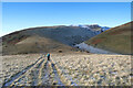
The col above Mousthwaite Cove
by Andy Waddington geograph for square NY3427 Category: Col A broad footpath descends from Souther Fell towards the col which falls steeply... (more)
|
|
Col between Meall Mòr and Cairn Gibbs
by Trevor Littlewood geograph for square NO1759 The wall is descending from Cairn Gibbs. Meall Mòr rises from the col where... (more)
Tags:
top:Boundary, BarrierX
Col
subject:ColX
Dry Stone WallX
type:GeographX
Hill WalkerX
Post and Wire FenceX
top:Rocks, Scree, CliffsX
top:Sport, LeisureX
top:UplandsX
|
|
Green Bank
by Mick Garratt for square NZ5203 Ive entitled this Green Bank.
Thats the name of the slight rise that can... (more)
|
|
Col south-west of summit of Creag Leacach
by Trevor Littlewood geograph for square NO1574 Creag Leacach is a Munro on the eastern side of Gleann Beag. The col is a gap... (more)
|
|
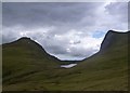
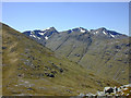
Col between Pap of Glencoe and Sgorr nam Fiannaidh
by Trevor Littlewood geograph for square NN1259 The ground rises steeply from the col with much rock to be encountered on the... (more)
|
|
Skiddaw south ridge
by Andy Waddington geograph for square NY2628 Category: Col The voie normale on Skiddaw descends towards the col between the main summit and... (more)
|

|
Back of the Cleveland Hills
by Mick Garratt for square NZ5403 What is this life if, full of care,
We have no time to stand and stare.
So... (more)
Tags:
subject:ColX
Col
type:Cross GridX
DaleX
top:Geological InterestX
HillsX
MedievalX
MoorsX
North Yorkshire MoorsX
St Patricks DayX
|
|
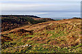
Col between Seatallan and Middle Fell
by Trevor Littlewood geograph for square NY1408 Seen from the east face of Seatallan the col appears to be a boggy tract of... (more)
Tags:
top:Air, Sky, WeatherX
BogX
Col
subject:ColX
type:GeographX
Hill SlopeX
top:Lakes, Wetland, BogX
Snow PatchesX
top:UplandsX
|
|
Gribdale Gate
by Mick Garratt geograph for square NZ5911 I have never really understood where Gribdale is. The oldest Ordnance Survey map... (more)
|
|
Wall crossing col connecting Mount Blair with Over Craig
by Trevor Littlewood geograph for square NO1661 The col appears to have the name, Glack of the Barnetts.
Tags:
top:Boundary, BarrierX
subject:ColX
Col
Dry Stone WallX
type:GeographX
Heathery Mountain SlopeX
top:UplandsX
|
|
Donna Cross Col
by Mick Garratt geograph for square NZ5403 I havent seen the hills all day. The Cleveland Hills have been smothered by a... (more)
|
|
Garfitt Gap
by Mick Garratt geograph for square NZ5503 The col between Hasty Bank and Cold Moor above Great Broughton. The Wainstones... (more)
|
|
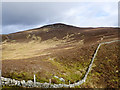
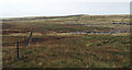
Fence line descending to col
by Trevor Littlewood geograph for square SD7595 The col between Swarth Fell and Swarth Fell Pike is broad, rather boggy and has... (more)
Tags:
BouldersX
top:Boundary, BarrierX
subject:ColX
Col
Grassy MoorlandX
top:MoorlandX
Post and Wire FenceX
top:Rocks, Scree, CliffsX
top:UplandsX
|
|
Col below Snouthead
by Jim Barton geograph for square NT3327 The col between Snouthead and Peat Law. The bank throwing a shadow is a linear... (more)
|
|
Col north of Carn Tuairneir
by Jim Barton geograph for square NJ0923 Higher on the ridge the heather is almost absent and progress much easier apart... (more)
|
|
Col below Peat Law
by Jim Barton geograph for square NT3326 The 1:25,000 map marks an ancient earthwork crossing the col and continuing... (more)
|
|
Col between Sgor Fhionnaich and Sgor a'Chleirich
by Alan Dawson geograph for square NC5647 Looking north to the col and cliffs - some rough ground to cross south of Carn... (more)
|
|
Bwlch rhwng Foel Boeth a Gallt y Daren / Col between Foel Boeth and Gallt y Daren
by Ian Medcalf geograph for square SH7734 Golygfa draw i'r Rhinogydd o'r fwlch rhwng Foel Boeth a Gallt y Daren... (more)
|
|
Bwlch Craig Cau Col
by Ian Medcalf geograph for square SH7012 Golygfa trwy'r bwlch i Ben y Gadair / A view through the col to Pen y Gadair.
|
|
Descending to the col below Cannock Hill
by Alan O'Dowd geograph for square NS6304 A broad, boggy col with a quad bike track leading towards Cannock Hill, with... (more)
|
|
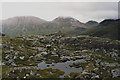
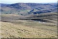
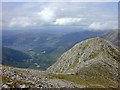
The col between Great End and Scafell Pike
by Graham Robson geograph for square NY2208 Looking down from Great End towards the col between the two mountains at the top... (more)
|

|
Lone boulder near moorland col
by Trevor Littlewood geograph for square NH1639 The col is between Beinn Dubh, rising to the right and Meallan Odhar, leftwards.... (more)
|
|
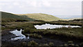
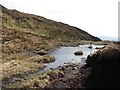
Pool at col between Kensgriff and Randygill Top
by Trevor Littlewood geograph for square SD6999 Grere Fell lies beyond the col and its pool with peaty areas.
|

|
Col between Black Hill and West Knock
by Richard Webb geograph for square NO4675 Looking eastwards along the electric fence towards the boggy col.
|
|
Col east of Moruisg
by Richard Webb geograph for square NH1049 The ridge east of Moruisg with a string of tops with steep faces falling to... (more)
|
|
Col east of Drumelzier Law
by Richard Webb geograph for square NT1530 The col between Middle Hill and Drumelzier Law.
|
|
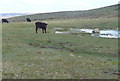
Cattle at Black Pool
by Graham Horn geograph for square SX6558 The pool in the col between Western Beacon and Butterdon Hill seems much smaller... (more)
|
|
A boggy col
by Richard Webb geograph for square NN4505 A peaty col between Beinn Bhreac and Beinn Chochan.
|
|
The col on Beinn Damh
by Nigel Brown geograph for square NG8751 Looking north over the col, with Meall Gorm rising beyond, and Beinn Alligin in... (more)
|
|
Western approach to the col
by Nigel Brown geograph for square SN7887 Category: Col With the summit of Pumlumon Fâch on the left and the north ridge of Pumlumon... (more)
|
|
The col below Pumlumon Fawr
by Nigel Brown geograph for square SN7887 Category: Col With Pumlumon Fawr on the right, and Pumlumon Fach on the left.
|
|
The col north east from An Cabar
by Nigel Brown geograph for square NH4566 Category: Col Soft green moss, like the rest of the Ben Wyvis plateau.
|
|
Lingmell Col
by Nigel Brown geograph for square NY2107 Category: Col Looking towards Broad Crag.
|
|
The col northwest of Moel y Llyn
by Nigel Brown geograph for square SN7192 Category: Col With one of Moel y Llyn's several cairns visible on the skyline.
|
|
The col on Cul Mòr
by Nigel Brown geograph for square NC1511 Category: Col With Creag nan Calman on the left and Cul Beag in the distance.
|
|
Col between A' Choinneach and Bynack More
by Nigel Brown geograph for square NJ0305 Category: Col Mainly grass, with the odd sandy patch. Bynack More can be seen ahead.
|
|
East of Beinn Achaladair
by Nigel Brown geograph for square NN3543 Category: Col Looking back at Beinn Achaladair from over the col to the east.
|
|
The col on the Buachaille Etive Beag
by Nigel Brown geograph for square NN1854 Category: Col Looking down from the steep slopes of Stob Coire Raineach, with the less steep... (more)
|
|
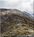
Bealach an t-Sron
by Nigel Brown geograph for square NN1354 Category: Col This little col is where you may finally end up if you follow the normal route... (more)
|