Geograph - photograph every grid square
About tags on Geograph
Tags
Geographical Context
Subjects
Types
Other Prefixes
Public Tags
Related Tags
|
Coverage Map
Tag:
Cropton·Forest
Showing images tagged with
Cropton Forest
tag.
View all tagged images
-
In Browser
Search within these images
:
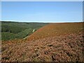
Contrast between moorland and forest
by
Martin Dawes
geograph for square
SE8293
To the right the autumnal shades of Levisham Bottoms. To the left the eastern... (
more
)
Tags:
Cropton Forest
type:
Geograph
X
Heather and Grass Moorland
X
top:
Moorland
X
Newton Dale
X
North York Moors National Park
X
North York Moors Railway
X
top:
Paths
X
top:
Railways
X
top:
Uplands
X
top:
Woodland, Forest
X
Newtondale & Levisham Moor
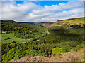
by
Scott Robinson
for square
SE8293
Taken from Skelton's Tower looking in a northerly direction. Levisham Moor... (
more
)
Tags:
top:
Air, Sky, Weather
X
Cropton Forest
type:
Cross Grid
X
country:
England
X
top:
Geological Interest
X
near:
Levisham
X
Levisham Moor
X
top:
Moorland
X
Newtondale
X
national park:
North York Moors
X
North York Moors
X
North York Moors National Park
X
North Yorkshire
X
North Yorkshire Moors
X
railway:
North Yorkshire Moors Railway
X
North Yorkshire Moors Railway
X
Nymr
X
top:
Railways
X
subject:
Sky
X
Sky Blue
X
season:
Summer
X
Trees
X
top:
Uplands
X
subject:
View
X
View
X
View Across Valley
X
View From Hillside
X
View Point
X
Woodland
X
subject:
Woodland
X
top:
Woodland, Forest
X
Woods
X
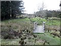
The bridge over Blawath Beck at Wardle Green
by
Martin Dawes
geograph for square
SE8296
The bridleway has come over the open moorland to Wardle Green and is now... (
more
)
Tags:
Beck
X
Bridleway
X
Bridleway Bridge
X
Cropton Forest
type:
Geograph
X
top:
Moorland
X
top:
Paths
X
top:
Rivers, Streams, Drainage
X
Ruined Farm
X
top:
Uplands
X
top:
Woodland, Forest
X
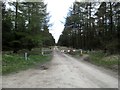
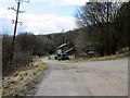
No Through Road in Cropton Forest
by
Martin Dawes
geograph for square
SE8295
It used to be an open road
Tags:
Bridleway
X
Cropton Forest
Forestry Commission Road
X
type:
Geograph
X
top:
Paths
X
Road Barrier
X
top:
Roads, Road Transport
X
top:
Uplands
X
top:
Woodland, Forest
X
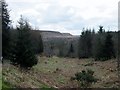
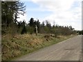
Brown Howe Road toward Brown Howe Farm
by
Martin Dawes
geograph for square
SE8094
A patch of grassland in Cropton Forest.
Tags:
Cropton Forest
Forestry Commission Road
X
type:
Geograph
X
top:
Grassland
X
top:
Roads, Road Transport
X
top:
Uplands
X
top:
Woodland, Forest
X
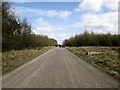
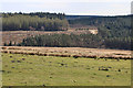
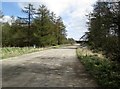
A long straight on Brown Howe Road
by
Martin Dawes
geograph for square
SE8094
Forestry Commission road through Cropton Forest
Tags:
Cropton Forest
Forestry Commission Road
X
type:
Geograph
X
top:
Moorland
X
top:
Roads, Road Transport
X
top:
Uplands
X
top:
Woodland, Forest
X
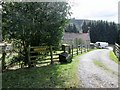
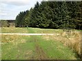
Track to Kale Pot House
by
Martin Dawes
geograph for square
SE8193
Smallholding in Cropton Forest
Tags:
Cropton Forest
Farm Access Road
X
top:
Roads, Road Transport
X
top:
Uplands
X
top:
Village, Rural Settlement
X
top:
Woodland, Forest
X
Forest drive past Gallock Hill
by
Martin Dawes
geograph for square
SE8293
Newtondale forest drive
Tags:
Cropton Forest
Forest Drive
X
top:
Roads, Road Transport
X
top:
Uplands
X
top:
Village, Rural Settlement
X
top:
Woodland, Forest
X
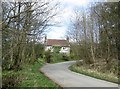
Holiday cottages in the Forest
by
Martin Dawes
geograph for square
SE8192
The Whitby and Pickering Railway Company opened in 1836 and closed in 1965 these... (
more
)
Tags:
top:
Business, Retail, Services
X
Cropton Forest
Forest Drive
X
Holiday Cottages
X
top:
Roads, Road Transport
X
top:
Uplands
X
top:
Village, Rural Settlement
X
top:
Woodland, Forest
X
Forest track called Hardigate Road
by
Martin Dawes
geograph for square
SE8192
This runs to Levisham Station the houses to the right are old railway cottages... (
more
)
Tags:
Cropton Forest
Forest Drive
X
Holiday Cottages
X
top:
Roads, Road Transport
X
top:
Uplands
X
top:
Village, Rural Settlement
X
top:
Woodland, Forest
X
Looking into Newton Dale from Raper's Farm
by
Martin Dawes
geograph for square
SE8293
The road to the left is Newtondale Forest Drive
Tags:
Cropton Forest
Forest Track
X
top:
Roads, Road Transport
X
top:
Uplands
X
top:
Woodland, Forest
X
Forest track in Newton Dale
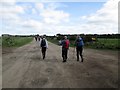
by
Martin Dawes
geograph for square
SE8294
The track to Kidstye Farm is to the right of the walkers
Tags:
Cropton Forest
Forest Track
X
top:
Roads, Road Transport
X
top:
Uplands
X
top:
Woodland, Forest
X
Felling in progress
by
Pauline E
geograph for square
SE8097
View across Tranmire Bogs to the forest edge,
Tags:
Cropton Forest
place:
Wheeldale
X
top:
Woodland, Forest
X
Bridleway at Wardle Green
by
Martin Dawes
geograph for square
SE8296
The forest track going left to right is also a restricted bridleway
Tags:
Bridleway
X
Cropton Forest
Forestry Commission Road
X
type:
Geograph
X
top:
Moorland
X
top:
Paths
X
top:
Roads, Road Transport
X
top:
Uplands
X
top:
Woodland, Forest
X
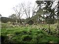
Farm ruin at Wardle Green
by
Martin Dawes
geograph for square
SE8296
When the Keldy Castle Estate was sold in 1893 this farm was still standing and... (
more
)
Tags:
Bridleway
X
Cropton Forest
type:
Geograph
X
top:
Grassland
X
top:
Moorland
X
top:
Paths
X
Ruined Farm
X
top:
Uplands
X
top:
Woodland, Forest
X
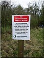
Have you a legal right
by
Martin Dawes
for square
SE8295
Brown Howe Road has a locked barrier across it at this point
Tags:
Bridleway
X
type:
Close Look
X
Cropton Forest
Forestry Commission Road
X
No Unauthorised Vehicle Access Sign
X
top:
Paths
X
top:
Roads, Road Transport
X
top:
Uplands
X
top:
Woodland, Forest
X
Brown Howe Road toward Stape
by
Martin Dawes
geograph for square
SE8195
Tags:
Cropton Forest
Forestry Commission Road
X
type:
Geograph
X
top:
Roads, Road Transport
X
top:
Uplands
X
top:
Woodland, Forest
X
Brown Howe Road at Wardle Rigg
by
Martin Dawes
geograph for square
SE8195
The access road to the property is on the right
Tags:
Access Road
X
Cropton Forest
Forestry Commission Road
X
type:
Geograph
X
top:
Roads, Road Transport
X
top:
Uplands
X
top:
Village, Rural Settlement
X
top:
Woodland, Forest
X
Mauley Cross Brown Howe Road
by
Martin Dawes
geograph for square
SE7994
The cross is carved from one complete block of stone. It is a boundary stone for... (
more
)
Tags:
Ancient Boundary Stone
X
top:
Boundary, Barrier
X
Cropton Forest
Forestry Commission Road
X
type:
Geograph
X
Mauley Cross
X
top:
Moorland
X
top:
Roads, Road Transport
X
top:
Uplands
X
top:
Woodland, Forest
X
Brown Howe Road. No longer a through road
by
Martin Dawes
geograph for square
SE7994
There is now a locked barrier across the road after Wardle Rigg. Mauley Cross is... (
more
)
Tags:
Cropton Forest
Forestry Commission Road
X
type:
Geograph
X
top:
Moorland
X
top:
Roads, Road Transport
X
top:
Uplands
X
top:
Woodland, Forest
X
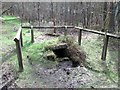
Old Wives Well
by
Martin Dawes
geograph for square
SE7994
This well used to have a wooden door on the front when it was used by the local... (
more
)
Tags:
Cropton Forest
type:
Geograph
X
top:
Lakes, Wetland, Bog
X
top:
Moorland
X
top:
Paths
X
Spring Outlet
X
top:
Uplands
X
Well
X
top:
Woodland, Forest
X
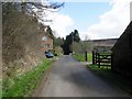
Stape Inn Keys Beck Road
by
Martin Dawes
geograph for square
SE7993
Still showing on the map as Hare and Hounds. I have a sale document from 1893... (
more
)
Tags:
Cropton Forest
former:
Farm
X
type:
Geograph
X
top:
Housing, Dwellings
X
Minor Road
X
top:
Roads, Road Transport
X
top:
Uplands
X
top:
Village, Rural Settlement
X
top:
Woodland, Forest
X
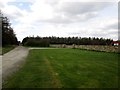
Rough pasture at Gallock Hill
by
Martin Dawes
geograph for square
SE8293
On the other side of Newton Dale can be seen Skelton Tower
Tags:
Cropton Forest
Dry Stone Walls
X
Rough Pasture
X
top:
Uplands
X
top:
Village, Rural Settlement
X
top:
Woodland, Forest
X
View more in the Image Search
or
in Browser
View images matching 'Cropton Forest' anywhere
in
the tags
Don't click these:
PotMel 1
PotMel 2
☰
Home
View
Search
Marked Images
Maps
Browser
Explore
Showcase
New Images
Collections
Interact
Games
Discussions
Blog
Contributors
Submit
Statistics
Leaderboards
General
FAQ
Help Pages
Sitemap
Contact Us
Support Us
sponsored by
🔍
What to search:
Photos
Enter keywords or a location/postcode to search nearby images
Enter a Grid Reference
Placenames
Collections
Website Pages
Everything
Others:
Advanced Search
|
Image Browser
Or:
Coverage Map
|
Searchable Map
You are not logged in
login
|
register