|
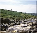
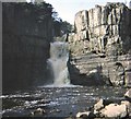
Holwick Fell, High Force (1970)
by Stanley Howe
geograph for square NY8728
Looking upstream from the top of the falls.
|
|
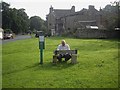
Mediaeval stocks on the village green, Romaldkirk (2013)
by Stanley Howe
geograph for square NY9922
|
|
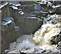
Top step of High Force waterfall (1970)
by Stanley Howe
geograph for square NY8728
Water flow at a low ebb!
|
|
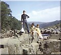
The Great Whin Sill, High Force (1970)
by Stanley Howe
geograph for square NY8728
On the edge.
|
|
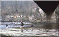
River Tees at Whorlton (1971)
by Stanley Howe
geograph for square NZ1014
Underneath the road bridge. The old toll booth can be seen in the centre rear.
|
![NY9321 : View across Lunedale [1971] by Stanley Howe](https://s1.geograph.org.uk/geophotos/05/90/79/5907933_75ad2bb5_120x120.jpg)
|
View across Lunedale [1971]
by Stanley Howe
geograph for square NY9321
Towards a road junction above the reservoirs in Lunedale.
|
|
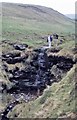
Waterfall on the lower slopes of Brownberry (1971)
by Stanley Howe
geograph for square NY9321
|
|
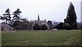
Whorlton Parish Church and graveyard (1971)
by Stanley Howe
geograph for square NZ1014
By village green.
|
|
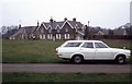
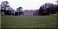
The Green, Whorlton village (1971)
by Stanley Howe
geograph for square NZ1014
The new Vauxhall Victor Estate was being run-in prior to being leisurely driven... (more)
|
|
Entry to Whorlton Village from the south (1971)
by Stanley Howe
geograph for square NZ1014
The path ahead goes along the top of Whorlton Banks, on the north bank of the... (more)
|

|
Downstream River Tees, Whorlton Bridge (1971)
by Stanley Howe
geograph for square NZ1014
Confluence of Whorlton beck with the River Tees occurs at the far reach (L) of... (more)
|
|
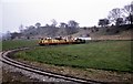
Miniature Railway at Whorlton Lido (1971)
by Stanley Howe
geograph for square NZ1014
On flood plain of River Tees.
|
|
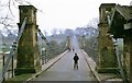
View across River Tees, Whorlton Bridge (1971)
by Stanley Howe
geograph for square NZ1014
Old tollbooth (disused) on right. Lido on opposite bank (to left).
|
|
Wycliffe Hall, Wycliffe, Teesdale
by Stanley Howe
geograph for square NZ1114
See Link for some history. |

|
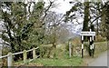
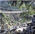
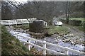
Pathway over Wynch Bridge (1970)
by Stanley Howe
for square NY9027
Across the River Tees at Newbiggin.
|
|
Wynch Bridge, Newbiggin (1970)
by Stanley Howe
geograph for square NY9027
A foot bridge over the River Tees.
|
|
Kirk Inn and Stocks, Romaldkirk (1970)
by Stanley Howe
geograph for square NY9922
|
|
The 3-step northern fall at High Force
by Stanley Howe
geograph for square NY8828
The southern fall (down the fissure at extreme right) only springs into life... (more)
|
|
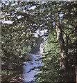
View to the pool at the foot of High Force (1970)
by Stanley Howe
geograph for square NY8828
From the path connecting the falls on the River Tees to High Force Hotel. The... (more)
|
|
Footbridge and Ford over Eggleston Burn (1971)
by Stanley Howe
geograph for square NY9824
Re-scanned Kodachrome slide from April 1971.
|