Public Tags
Tag: Dumbarton·Rock
Other tags: landmark:Dumbarton Rock
place:Dumbarton Rock
Showing latest 50 of 109 images tagged with Dumbarton Rock tag.
|
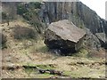
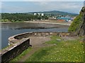
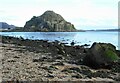
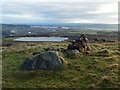
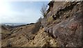
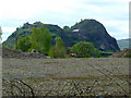
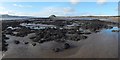
Fallen boulder beside Dumbarton Rock
by Lairich Rig geograph for square NS3974 Category: Geological feature This is easily the largest of several huge boulders that have broken off from... (more)
|
|
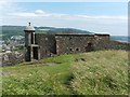
Dumbarton Rock: sentry box and curtain wall
by Lairich Rig geograph for square NS4074 Category: Fortifications [This is one of a linked series of articles about Dumbarton Rock. See the end of... (more)
Tags:
period:18th CenturyX
ArchaeologyX
top:Defence, MilitaryX
Defensive WallX
top:Derelict, DisusedX
place:Dumbarton Rock
top:Historic Sites and ArtefactsX
former:Sentry BoxX
|
|
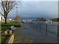
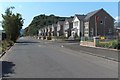
Flooding at Riverside Lane
by Lairich Rig geograph for square NS3975 This riverside path runs between the River Leven and the car parks that are... (more)
|
|
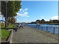
Riverside walkway, Dumbarton
by Lairich Rig geograph for square NS3975 The point from which this picture was taken is about halfway along the part of... (more)
Tags:
landmark:Dumbarton Rock
type:GeographX
subject:PathX
top:PathsX
top:Rivers, Streams, DrainageX
|
|
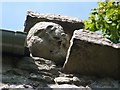
Dumbarton Rock: Carved face on Guard House
by Lairich Rig for square NS3974 Category: Stone carvings [This is one of a linked series of articles about Dumbarton Rock.]
The... (more)
Tags:
period:16th CenturyX
Carved StoneX
bucket:CloseCropX
place:Dumbarton Rock
top:Historic Sites and ArtefactsX
person:William WallaceX
|
|
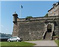
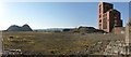
Dumbarton Rock: King George's Battery
by Lairich Rig for square NS4074 Category: Battery [This is the first of a linked series of articles about the various present-day... (more)
Tags:
period:18th CenturyX
top:Defence, MilitaryX
top:Derelict, DisusedX
place:Dumbarton Rock
top:Historic Sites and ArtefactsX
|
|
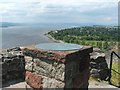
Dumbarton Rock: White Tower Crag
by Lairich Rig for square NS3974 Category: Viewpoint [This is the last in a linked series of articles about Dumbarton Rock. See the... (more)
|
|
Dumbarton Rock: the Wallace Tower
by Lairich Rig for square NS3974 Category: Ruins [This is one of a linked series of articles about Dumbarton Rock. See the end of... (more)
Tags:
period:15th CenturyX
place:Dumbarton Rock
top:Historic Sites and ArtefactsX
person:William WallaceX
|
|
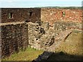
Dumbarton Rock: Bower Battery
by Lairich Rig geograph for square NS3974 Category: Battery [This is one of a linked series of articles about Dumbarton Rock.]
The... (more)
Tags:
period:18th CenturyX
top:Defence, MilitaryX
Defensive WallX
top:Derelict, DisusedX
place:Dumbarton Rock
top:Historic Sites and ArtefactsX
|
|
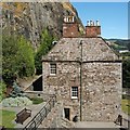
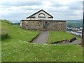
Dumbarton Rock: The Governor's House
by Lairich Rig geograph for square NS4074 Category: Historic building [This is one of a linked series of articles about Dumbarton Rock. See the end of... (more)
|
|
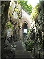
Dumbarton Rock: the Portcullis Arch
by Lairich Rig for square NS3974 Category: Arches [This is one of a linked series of articles about Dumbarton Rock. See the end of... (more)
|
|
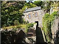
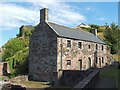
Dumbarton Rock: The Guard House
by Lairich Rig geograph for square NS3974 Category: Historic building [This is one of a linked series of articles about Dumbarton Rock. See the end of... (more)
Tags:
period:16th CenturyX
period:18th CenturyX
place:Dumbarton Rock
former:Guard HouseX
top:Historic Sites and ArtefactsX
|
|
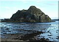
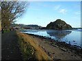
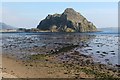
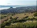
Dumbarton Rock
by Richard Sutcliffe geograph for square NS3974 Volcanic plug beside the confluence of the River Leven and River Clyde. It is... (more)
Tags:
Dumbarton Rock
top:Estuary, MarineX
type:GeographX
top:Geological InterestX
top:Historic Sites and ArtefactsX
river:River ClydeX
river:River LevenX
top:Rivers, Streams, DrainageX
subject:RockX
top:Rocks, Scree, CliffsX
ShoreX
Volcanic PlugX
|
|
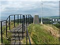
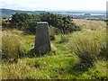
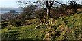
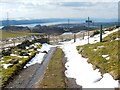
Trig point on Dumbarton Rock
by Lairich Rig geograph for square NS3974 Category: Trig Point Dumbarton Rock has two peaks: the lower one, to the east, is called the Beak;... (more)
|
|
Dumbarton Rock: the Magazine
by Lairich Rig geograph for square NS4074 Category: Magazine [This is one of a linked series of articles about Dumbarton Rock. See the end of... (more)
Tags:
period:18th CenturyX
top:Defence, MilitaryX
top:Derelict, DisusedX
place:Dumbarton Rock
top:Historic Sites and ArtefactsX
former:MagazineX
|
|
Dumbarton Rock: the French Prison
by Lairich Rig geograph for square NS3974 Category: Historic building [This is one of a linked series of articles about Dumbarton Rock. See the end of... (more)
|
|
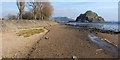
Dumbarton Rock
by Richard Sutcliffe geograph for square NS3974 Volcanic plug beside the confluence of the River Leven and River Clyde. It is... (more)
Tags:
ConfluenceX
top:Defence, MilitaryX
Dumbarton Rock
top:Estuary, MarineX
type:GeographX
top:Geological InterestX
top:Historic Sites and ArtefactsX
river:River ClydeX
river:River LevenX
top:Rivers, Streams, DrainageX
subject:RockX
SSSIX
Volcanic PlugX
|
|
The former site of Ballantine's Distillery
by Lairich Rig geograph for square NS3975 Of the distillery buildings, only a single tower now remains; see NS3975 : Remains of Ballantine's Distillery... (more)
|
|
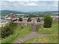
Dumbarton Rock: Prince of Wales Battery
by Lairich Rig geograph for square NS4074 Category: Battery [This is one of a linked series of articles about Dumbarton Rock. See the end of... (more)
Tags:
period:18th CenturyX
CannonX
top:Defence, MilitaryX
top:Derelict, DisusedX
place:Dumbarton Rock
top:Historic Sites and ArtefactsX
|
|
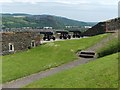
Dumbarton Rock: Duke of Argyll's Battery
by Lairich Rig geograph for square NS3974 Category: Battery [This is one of a linked series of articles about Dumbarton Rock. See the end of... (more)
Tags:
period:18th CenturyX
CannonX
top:Defence, MilitaryX
top:Derelict, DisusedX
place:Dumbarton Rock
top:Historic Sites and ArtefactsX
|
|
Dumbarton Castle: western curtain wall
by Lairich Rig geograph for square NS3974 Category: Fortifications [This is one of a linked series of articles about Dumbarton Rock. See the end of... (more)
Tags:
period:18th CenturyX
CannonX
top:Defence, MilitaryX
Defensive WallX
top:Derelict, DisusedX
place:Dumbarton Rock
top:Historic Sites and ArtefactsX
|
|
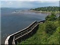
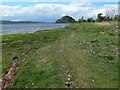
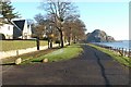
Shoreline path
by Richard Sutcliffe geograph for square NS3974 Looking along the path at the edge of Levengrove Park, beside the River Clyde.... (more)
Tags:
Dumbarton Rock
top:Estuary, MarineX
type:GeographX
top:Geological InterestX
subject:PathX
top:PathsX
river:River ClydeX
top:Rivers, Streams, DrainageX
top:Rocks, Scree, CliffsX
ShoreX
Volcanic PlugX
|
|
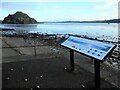
Visitor information
by Richard Sutcliffe geograph for square NS3974 One of many very clear and informative panels around Levengrove Park, produced... (more)
Tags:
Dumbarton Rock
top:Estuary, MarineX
type:GeographX
top:Geological InterestX
Information PanelX
river:River ClydeX
top:Rivers, Streams, DrainageX
top:Rocks, Scree, CliffsX
Volcanic PlugX
|
|
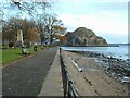
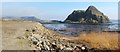
The shore beside Levengrove Park
by Richard Sutcliffe geograph for square NS3974 Looking towards Dumbarton Rock. There is a steep drop of several metres from the... (more)
Tags:
Dumbarton Rock
top:Estuary, MarineX
type:GeographX
top:Geological InterestX
top:Park and Public GardensX
top:PathsX
river:River ClydeX
river:River LevenX
top:Rocks, Scree, CliffsX
subject:ShoreX
Volcanic PlugX
|
|
Shoreline path
by Richard Sutcliffe geograph for square NS3974 Looking towards the confluence of the River Leven and River Clyde beside... (more)
Tags:
ConfluenceX
Dumbarton Rock
top:Estuary, MarineX
type:GeographX
top:Geological InterestX
subject:PathX
top:PathsX
river:River ClydeX
river:River LevenX
top:Rivers, Streams, DrainageX
Volcanic PlugX
|
|
Remains of a pool
by Lairich Rig geograph for square NS3974 Category: Beach For the main description, see NS3974 : Remains of a pool. The present photograph shows the same... (more)
Tags:
top:CoastalX
place:DumbartonX
landmark:Dumbarton Rock
top:Estuary, MarineX
Levengrove ParkX
ruin:PoolX
|
|
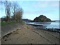
The shoreline at Sandpoint
by Lairich Rig geograph for square NS3974 Category: Shore The very straight line of the shore here is the result of fairly recent work,... (more)
|
|
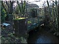
Disused railway bridge over Gruggies Burn
by Lairich Rig geograph for square NS4074 Dumbarton Rock can be seen indistinctly in the background. Click on the first... (more)
Tags:
subject:BridgeX
top:Derelict, DisusedX
Dismantled Railway LineX
landmark:Dumbarton Rock
type:GeographX
top:RailwaysX
top:Rivers, Streams, DrainageX
|
|
|
Field near Kipperoch Farm
by Lairich Rig geograph for square NS3778 Although the field is its focus, the picture was also intended to convey the... (more)
Tags:
landmark:Dumbarton Rock
landmark:Dumbuck QuarryX
top:Farm, Fishery, Market GardeningX
subject:FieldX
bucket:WideangleX
|
|
Remains of a timber pond
by Lairich Rig geograph for square NS3974 Category: Timber ponds The most obvious feature of this photograph is Dumbarton Rock. However, my... (more)
Tags:
ArchaeologyX
top:CoastalX
place:DumbartonX
landmark:Dumbarton Rock
top:Estuary, MarineX
top:Historic Sites and ArtefactsX
ruin:Timber PondX
|
|
Castle Road
by Lairich Rig geograph for square NS4074 Category: Road This is a view along Castle Road. Dumbarton Rock, with some of the buildings of... (more)
|
|
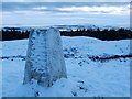
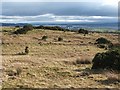
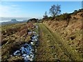
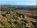
Trig point on Pappert Hill
by Lairich Rig geograph for square NS4280 Category: Trig Point Compare NS4280 : Trig point on Pappert Hill.
Behind the upper-right corner of the trig point, part of... (more)
Tags:
landmark:Dumbarton Rock
place:Pappert HillX
weather:SnowX
Trig PointX
top:UplandsX
season:WinterX
|
|
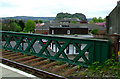
Dumbarton East railway station
by Thomas Nugent geograph for square NS4075 The bridge over Glasgow Road offers a view of Dumbarton Rock.
Tags:
top:City, Town CentreX
place:DumbartonX
Dumbarton EastX
Dumbarton Rock
top:Geological InterestX
Railway StationX
top:RailwaysX
|
|
Cattle grid on the Crags Circular Path
by Lairich Rig geograph for square NS4375 The River Clyde can be seen in the background, with Dumbarton Rock visible on... (more)
Tags:
subject:Cattle GridX
landmark:Dumbarton Rock
landmark:Dumbuck QuarryX
type:GeographX
top:Roads, Road TransportX
The Crags Circular PathX
|
|
Trig point near Kipperoch Farm
by Lairich Rig geograph for square NS3778 Category: Trig Point In this view, Dumbuck Hill (NS4274 : Dumbuck Quarry) can be seen directly behind the trig... (more)
|
|
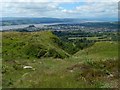
South-western slopes of Dumbowie Hill
by Lairich Rig geograph for square NS4275 The picture was taken from the dun on the hill's south-eastern summit, from... (more)
|
|
The top of Carman Hill
by Lairich Rig geograph for square NS3779 Right of centre in the foreground is a modern cairn (made within the last... (more)
|
|
Black Craig
by Lairich Rig geograph for square NS4377 The feature is named on the 1:25000 map. For a view in the opposite direction... (more)
Tags:
landmark:Dumbarton Rock
subject:Geological FeatureX
top:Rocks, Scree, CliffsX
The Overtoun BurnX
bucket:WideangleX
|
|
Old dry-stone wall
by Lairich Rig geograph for square NS4175 The old wall is at the base of Dumbowie Hill, on the western side. Far below,... (more)
|
|
Ladder-like pattern of ditches, Carman Muir
by Lairich Rig geograph for square NS3678 Category: Ditch A prominent ladder-like pattern of ditches runs for a considerable distance... (more)
|
|
Path near the top of the Long Crags
by Lairich Rig geograph for square NS4376 A path, entering at the lower-left corner of the image, is heading back towards... (more)
|
|
Track leading from Dumbowie Hill
by Lairich Rig geograph for square NS4175 Followed in this direction, the track leads to a path that was the old route of... (more)
Tags:
landmark:Dumbarton Rock
top:PathsX
|
|
Dumbowie Hill: north-western summit
by Lairich Rig geograph for square NS4275 This summit lacks the archaeological interest of the south-eastern one, but it... (more)
|
|
Lang Craigs Woodland
by Lairich Rig for square NS4276 The view is from the top of NS4376 : The Long Crags, looking over the edge of the cliffs.... (more)
|
|
Dumbarton foreshore
by Lairich Rig geograph for square NS4074 Dumbarton Rock is ahead. Another path is a little further inland, separated from... (more)
|
|
Dumbarton Rock
by Thomas Nugent geograph for square NS3975 Viewed from Castle Street.
Tags:
top:Construction, DevelopmentX
top:Derelict, DisusedX
place:DumbartonX
Dumbarton Rock
top:Geological InterestX
top:Historic Sites and ArtefactsX
top:Suburb, Urban FringeX
|
|
The Crags Circular Path - leaving the forest
by Lairich Rig geograph for square NS4375 Category: Footpath The signposted Crags Circular Path leads uphill from Dumbarton, past Overtoun... (more)
Tags:
landmark:Dumbarton Rock
landmark:Dumbuck QuarryX
top:PathsX
near:RiggangowerX
weather:SnowX
The Crags Circular PathX
near:The Lang CraigsX
|
|
Clydeview, near the shore at Levengrove
by Lairich Rig geograph for square NS3974 Category: Houses This rather short row of houses is called Clydeview; the photograph was taken... (more)
Tags:
top:CoastalX
place:DumbartonX
landmark:Dumbarton Rock
near:Levengrove ParkX
near:River ClydeX
top:Roads, Road TransportX
|
|
Boulders on Carman Hill
by Lairich Rig geograph for square NS3779 The most prominent group, shown in NS3779 : View over ancient hill-fort, is further up the slope, behind... (more)
Tags:
landmark:Dumbarton Rock
landmark:Dumbuck QuarryX
type:GeographX
subject:RockX
top:Rocks, Scree, CliffsX
landmark:The Long CragsX
top:UplandsX
|
|
Dumbuck Crannog
by Lairich Rig geograph for square NS4173 Expand the end-note for a detailed description; click on the end-note title for... (more)
Tags:
subject:ArchaeologyX
top:CoastalX
CrannogX
landmark:Dumbarton Rock
type:GeographX
top:Historic Sites and ArtefactsX
bucket:WideangleX
|