Public Tags
Tag: Ennerdale·Water
Showing images tagged with Ennerdale Water tag.
|
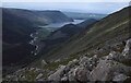
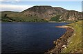
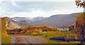
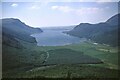
View to Ennerdale Water
by Philip Halling geograph for square NY1714 View down the vale of Ennerdale to Ennerdale Water at the bottom. Viewed from... (more)
|
|
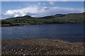
The Ennerdale shore
by Philip Halling geograph for square NY1114 The Ennerdale Water shore near its eastern end. The low fell in shadow is... (more)
|
|
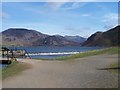
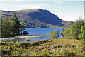
Weir at Ennerdale Water
by John Light geograph for square NY0815 Category: Weir To the left is a bridge giving access to the north side of Ennerdale Water while... (more)
|
|
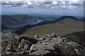
Ennerdale Water viewed from High Stile
by Philip Halling geograph for square NY1614 View west from High Stile with Ennerdale Water visible in the valley below
|
|
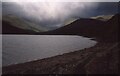
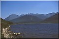
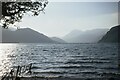
Ennerdale Water
by Philip Halling geograph for square NY0915 The south shore of Ennerdale Water, Great Borne is the fell in the background.
|
|
Ennerdale Water
by Philip Halling geograph for square NY0915 View across the western part of Ennerdale Water.
|
|
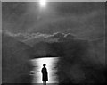
Moonlight on Ennerdale Water, 1961
by Ben Brooksbank for square NY0815 View eastward near Ennerdale Bridge: we had been married the day before!
Tags:
top:Air, Sky, WeatherX
Ennerdale Water
HoneymoonX
top:Lakes, Wetland, BogX
MoonlightX
top:People, EventsX
|
|
SE to Ennerdale Lake, Ennerdale Fell and mountains beyond, 1966
by Ben Brooksbank geograph for square NY0917 View from slopes of Kelton Fell above Crossdale: to left is Great Borne (2,019... (more)
|
|
SE from Mireside to Ennerdale Fell, 1966
by Ben Brooksbank geograph for square NY1016 Beyond the Ennerdale Lake and Fell are Steeple (2,627 ft.), Haycock (2,619 ft.)... (more)
|
|
River Liza and Ennerdale Water
by Ian Taylor geograph for square NY1214 Crag Fell is in the background.
Tags:
Ennerdale Water
type:GeographX
subject:LakeX
top:Lakes, Wetland, BogX
River LizaX
top:Rivers, Streams, DrainageX
|
|
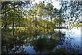
Ennerdale Water
by Ian Taylor geograph for square NY1114 Trees have occupied a small spur that extends into the lake.
Tags:
Ennerdale Water
type:GeographX
subject:LakeX
top:Lakes, Wetland, BogX
LakeshoreX
top:Woodland, ForestX
|
|
North shore of Ennerdale Water 1967
by Jim Barton geograph for square NY1114 The small peak of Steeple is on the skyline above the plantation on the spur of... (more)
Tags:
Ennerdale Water
FellsideX
Forestry PlantationsX
type:GeographX
national park:Lake DistrictX
top:Lakes, Wetland, BogX
top:UplandsX
View of MountainsX
top:Woodland, ForestX
|
|
Ennerdale Water from Lingmell, 1967
by Jim Barton geograph for square NY1313 The forestry plantations seen from the lower slopes of Lingmell, not to be... (more)
Tags:
Ennerdale Water
Forestry PlantationsX
type:GeographX
national park:Lake DistrictX
top:Lakes, Wetland, BogX
top:Woodland, ForestX
|
|
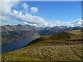
Ennerdale Water
by Jim Barton geograph for square NY0915 Looking up the lake towards Pillar in the distance, flanked by Bowness Knott and... (more)
Tags:
Ennerdale Water
FellsideX
type:GeographX
national park:Lake DistrictX
top:Lakes, Wetland, BogX
|
|
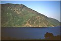
Crag Fell and Ennerdale Water
by Jim Barton geograph for square NY1015 Crag Fell shows its steepest side to the lake, seen from the north shore.
Tags:
CragsX
Ennerdale Water
FellsideX
type:GeographX
national park:Lake DistrictX
top:Lakes, Wetland, BogX
top:Rocks, Scree, CliffsX
top:UplandsX
|
|
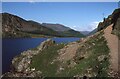
Robin Hood's Chair
by Philip Halling geograph for square NY1015 Robin Hood's Chair beside the footpath on the shore of Ennerdale Water.... (more)
|
|
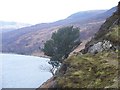
Lone tree on Anglers Crag
by John Light geograph for square NY1015 Category: Tree Only room for a small tree on this cliff. Taken during a walk around Ennerdale Water.
|
|
On Crag Fell
by Michael Graham geograph for square NY0914 Looking towards the head of Ennerdale with Pillar and Steeple snow capped.
Tags:
Ennerdale Water
top:UplandsX
|
|
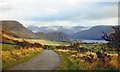
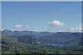
View up Ennerdale from Cauda Brow
by Christopher Hilton geograph for square NY0917 Tags:
Ennerdale Water
Lake DistrictX
national park:Lake DistrictX
place:Lake DistrictX
top:Lakes, Wetland, BogX
MountainsX
top:UplandsX
|