Public Tags
Tag: Gabions
Showing latest 50 of 89 images tagged with Gabions tag.
|
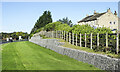
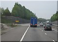
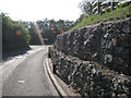
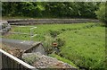
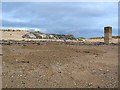
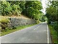
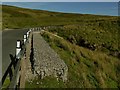
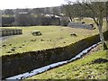
Gabions used as retaining wall on north side of A66
by Trevor Littlewood geograph for square NZ0912 Gabions - wire cages filled with rocks - at the edge of a wide grass verge of... (more)
Tags:
top:Boundary, BarrierX
top:Farm, Fishery, Market GardeningX
Gabions
type:GeographX
GrangeX
Grass VergeX
top:LowlandsX
Retaining WallX
top:Roads, Road TransportX
|
|
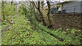
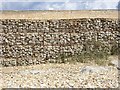
Gabions defending stream-side bank
by Trevor Littlewood geograph for square NY8636 Gabions, (wire-caged rocks), are used frequently to defend river banks from... (more)
Tags:
Gabions
type:GeographX
Hill SlopesX
top:Rivers, Streams, DrainageX
Small BuildingX
subject:StreamX
StreamX
top:UplandsX
top:Water ResourcesX
|
|
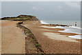
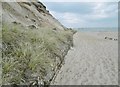
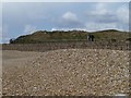
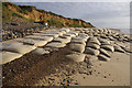
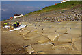
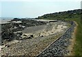
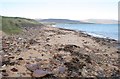
Gabions, Hengistbury Head Beach
by Rob Noble geograph for square SZ1690 These gabions (see Link
Tags:
BeachX
subject:CoastX
top:CoastalX
Coastal ErosionX
top:Estuary, MarineX
Gabions
Iron Age SettlementX
|

|
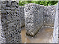
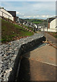
Gabions filled with reclaimed stone, Scottish Parliament
by Robin Stott for square NT2673 Accurately-made gabions act as huge building blocks which appear to be... (more)
Tags:
top:Construction, DevelopmentX
place:EdinburghX
postcode area:EH8X
Gabions
top:LowlandsX
Parlamaid Na H-AlbaX
Scottish Parliament BuildingX
top:Suburb, Urban FringeX
|
|
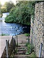
Gabions on steps down to the River Dearne
by Steve Fareham geograph for square SE4006 The handrails have gone! The steps give access under the road see SE4006 : The River Dearne passes under Storrs Mill Lane
|
|
Gabions by Winchester Services - M3
by Mr Ignavy geograph for square SU5235 Category: Gabions |
|
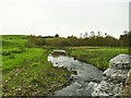
Otterburn Beck, with gabions
by Stephen Craven geograph for square SD8857 The gabions are presumably to prevent the beck eroding the adjacent road.
|
|
Woodland and Gabion wall behind The Chestnuts
by TCExplorer geograph for square SJ5307 |
|
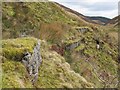
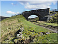
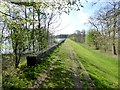
Gabions supporting the Whitendale aqueduct
by Stephen Craven geograph for square SD6654 The footpath on the east side of the dale follows the line of the aqueduct for... (more)
|
|
Hengistbury Head, gabion
by Mike Faherty geograph for square SZ1890 A low gabion, preventing erosion of sand from the cliff above.
|
|
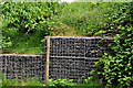
Field entrance blocked with gabions, below Calf Hill
by Christine Johnstone geograph for square SE4270 On the north side of the road between Milby and Thornton Bridge.
Tags:
Blocked Field EntranceX
top:Farm, Fishery, Market GardeningX
subject:FieldX
Gabion BoxesX
Gabions
HedgeX
HedgerowX
|
|
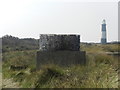
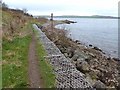
Gabion and lighthouse
by Peter Barr geograph for square TA4011 Gabions are used for stabilization of earth movement and erosion, river control,... (more)
|
|
Thames Barrier: onshore gabions
by Stephen Craven geograph for square TQ4179 I'm not sure if these stone-filled gabions (more usually seen along... (more)
|
|
Gabions, south end of Pettiford Lane
by Robin Stott geograph for square SP1563 It rather looks as though development at Yew Tree Farm, top right, has come so... (more)
|
|
Gabions, River Lagan, Edenderry, Belfast (August 2019)
by Albert Bridge geograph for square J3167 Gabions used to strengthen the riverbank close to Edenderry village... (more)
Tags:
place:BelfastX
top:Construction, DevelopmentX
Edenderry (Belfast)X
Gabions
type:GeographX
subject:River BankX
River BankX
River LaganX
top:Rivers, Streams, DrainageX
Vacant SiteX
|
|
Gabions near Crawfordsburn
by Albert Bridge for square J4782 Gabions, between the railway embankment (background) and the farm track seen in... (more)
|
|
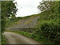
Gabions on Brackenley Lane
by Stephen Craven geograph for square SD9953 It would appear there has been some geotechnical engineering here, perhaps as a... (more)
|

|
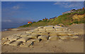
Doll, Mill Bay Cove
by Derek Harper for square SX8950 Is this Sindy or Barbie - or, indeed, someone else? From her perch in the wires... (more)
|
|
Brothie Burn and gabions
by Richard Sutcliffe geograph for square NS8993 Beside Whins Road.
|
|
Gabions at work
by Mr Ignavy geograph for square SZ1690 View from the beach close to Warren Hill.
|
|
Gabions at White Pits
by Mr Ignavy geograph for square SZ1690 Q. Why are they here?
A. To protect the ends of the 'Double Dyke'an... (more)
|
|
Inside "the Minotaur"
by Oliver Dixon for square NY6393 "The Minotaur" is part of the Kielder Sculpture Program and was... (more)
|
|
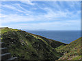
Cliff-side path at Whitby
by Bill Boaden geograph for square NZ8811 The paths and accompanying gabions are as much to support the cliff as to... (more)
|
|
Sea defences, Thorpeness
by Ian Taylor geograph for square TM4760 At the northern end of Thorpeness, several properties are close to the beach.... (more)
|
|
Sea defences, Thorpeness
by Ian Taylor geograph for square TM4760 At the northern end of Thorpeness, several properties are close to the beach.... (more)
|
|
Patching up the sea defences, Thorpeness
by Ian Taylor geograph for square TM4760 At the northern end of Thorpeness, several properties are close to the beach,... (more)
|
|
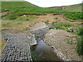
Outlet from Tacumshin Lake
by Oliver Dixon geograph for square T0505 There is no natural outlet for the waters of Tacumshin Lake which is held back... (more)
|
|
Gabions in Strathyre
by M J Richardson geograph for square NN5614 Preventing the hillside collapsing on to the A84 Callander-Lochearnhead road.
|
|
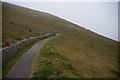
The West Island Way at Kilchattan
by Oliver Dixon geograph for square NS1054 The West Island Way is a 46-kilometre long distance walk which traverses the... (more)
|
|
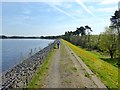
Gabions at Harlaw Reservoir
by M J Richardson geograph for square NT1865 Protection of the shore at the edge of a wild planting area.
|
|
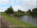
Gabion retaining wall
by Richard Sutcliffe geograph for square NN5800 Beside the B8034 next to the Lake of Menteith.
|
|
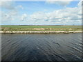
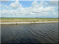
Sea defences
by Richard Sutcliffe geograph for square NT2789 Gabions in place along the shore south of Kirkcaldy to protect against sea erosion.
Tags:
top:CoastalX
top:Estuary, MarineX
Gabions
type:GeographX
top:Housing, DwellingsX
top:Rocks, Scree, CliffsX
subject:Sea DefencesX
|
|
Kelphope Burn
by M J Richardson geograph for square NT5156 With substantial bank erosion at a sharp bend, and gabions strengthening the... (more)
Tags:
Bank ErosionX
plant:BrackenX
BurnX
Gabions
type:GeographX
Kelphope ValleyX
place:Lammermuir HillsX
near:OxtonX
top:Rivers, Streams, DrainageX
place:Scottish BordersX
subject:StreamX
TreesX
top:UplandsX
|
|
Gabions in the stream
by Robert Graham geograph for square NZ1753 Stone filled wire baskets reinforcing the bank of the stream here on the Kyo... (more)
|
|
Gabions along the north bank, Manchester Ship Canal
by Christine Johnstone geograph for square SJ4777 At the boundary between Ince and Frodsham civil parish boundaries.
|
|
Distorted gabions, north bank, Manchester Ship Canal
by Christine Johnstone geograph for square SJ4677 What changed their shape?
|
|
Railway route approaching bridge
by Trevor Littlewood geograph for square NY8612 The railway route was that of the South Durham and Lancashire Union Railway but... (more)
Tags:
BridgeX
top:Derelict, DisusedX
Farm TrackX
Gabions
type:GeographX
Old Railway BedX
top:RailwaysX
top:Roads, Road TransportX
subject:TrackX
top:UplandsX
|
|
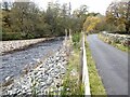
Restored road above Thompson's Well Bridge
by Oliver Dixon geograph for square NY6851 On my last visit in 2014, this length of the back road from Alston to Slaggyford... (more)
Tags:
Country RoadX
Gabions
Gabions on River BankX
type:GeographX
RiverX
top:Rivers, Streams, DrainageX
subject:RoadX
top:Roads, Road TransportX
StoneX
|
|
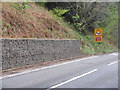
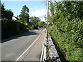
Gabions supporting the B6270
by Stephen Craven geograph for square NY8203 The location is shown as Shivery Gill on old maps. This may give a clue to the... (more)
|
|
Wall failure, Teignmouth Road, Torquay
by Derek Harper geograph for square SX9064 An update on SX9064 : Wall failure, Teignmouth Road, Torquay; the machinery has arrived. Somehow, the task looks... (more)
|
|
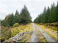
Forest road northward from stream crossing
by Trevor Littlewood geograph for square NR9990 The stream is a tributary of the Lephinmore Burn. It's crossed by the road... (more)
Tags:
Coniferous PlantationX
top:Farm, Fishery, Market GardeningX
Forest RoadX
Gabions
type:GeographX
top:Rivers, Streams, DrainageX
subject:RoadX
top:Roads, Road TransportX
top:UplandsX
|
|
Woodhouses Lane descending
by Trevor Littlewood geograph for square NZ2061 Woodhouses Lane contours around the eastern slope of the Derwent valley,... (more)
|
|
The beach, Brora
by Richard Sutcliffe geograph for square NC9104 Gabions and boulders are protecting the sand dunes at the back of the beach.
|
|
New housing, Paignton
by Derek Harper geograph for square SX8758 A gabion at the top of Clover Close, a new road of houses on the Fusion development.
Tags:
BarriersX
top:Construction, DevelopmentX
GabionX
type:GeographX
Housing EstateX
top:Housing, DwellingsX
StepsX
top:Suburb, Urban FringeX
|
|
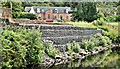
Dam, Hallington Reservoir West
by Oliver Dixon geograph for square NY9676 Constructed in 1887 by the Newcastle and Gateshead Water Company. Most... (more)
|
|
Dam, Hallington Reservoir West
by Oliver Dixon geograph for square NY9675 Constructed in 1887 by the Newcastle and Gateshead Water Company. Most... (more)
|
|
Bellingham Bridge and Riverside Park
by Oliver Dixon geograph for square NY8383 Beside the River North Tyne. Note the gabions securing the embankment on the way... (more)
|
|
Gabions alongside Apsley End Road, Shillington
by Humphrey Bolton geograph for square TL1233 These form the bank of a ditch and stop the footway from being undermined.
Tags:
DitchX
Gabions
type:GeographX
top:LowlandsX
top:Rivers, Streams, DrainageX
subject:RoadX
top:Roads, Road TransportX
top:Village, Rural SettlementX
|
|
Allt a' Bhùtha
by Trevor Littlewood geograph for square NG7488 The Allt a' Bhùtha drains water from the moorland hill of A' Cuaidh;... (more)
Tags:
Gabions
type:GeographX
Hill SlopesX
top:Rivers, Streams, DrainageX
subject:StreamX
Stream GrooveX
top:UplandsX
|
|
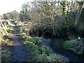
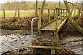
Footbridge over Holbeck
by Derek Harper geograph for square SE3464 Carrying footpath 15 26/6/1 over the stream. A small gabion has been used to... (more)
|