|
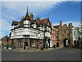
North Bar, Beverley
by Malc McDonald
geograph for square TA0239
Beverley North Bar, to the right of the image, is one of four gateways which... (more)
|
|
North Bar, Beverley
by Malc McDonald
geograph for square TA0339
Beverley North bar is one of four gateways which controlled access into the... (more)
|
|
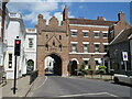
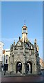
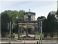
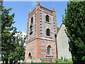
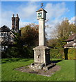
Market Cross, Beverley
by Malc McDonald
geograph for square TA0339
The Market Cross in Beverley was built in 1714. It is a Grade I listed... (more)
|
|
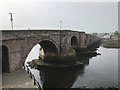
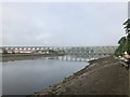
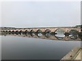
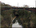
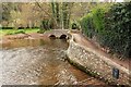
Berwick Bridge
by Jonathan Hutchins
geograph for square NT9952
The bridge was constructed between 1611 and 1624, and is Grade I listed, see... (more)
|
|
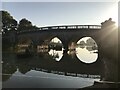
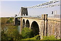
Royal Border Bridge
by Jonathan Hutchins
for square NT9953
|
|
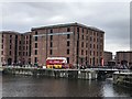
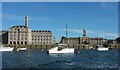
Merseyside Maritime Museum
by Jonathan Hutchins
for square SJ3489
A former warehouse, Grade I listed, see... (more)
|
|
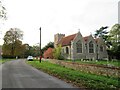
Church of St. Mary the Virgin, Little Easton, near Great Dunmow
by Malc McDonald
geograph for square TL6023
The church of St. Mary the Virgin in the village of Little Easton in north... (more)
|
|
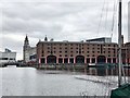
Albert Dock and the Merseyside Maritime Museum
by Jonathan Hutchins
geograph for square SJ3489
The Royal Liver Building is in the background.
|
|
Path at Ironbridge
by Malc McDonald
geograph for square SJ6703
A path along the bank of the River Severn at Ironbridge, with a view towards the... (more)
|
|
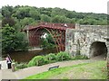
Ironbridge, from the bridge
by Malc McDonald
geograph for square SJ6703
A view from the iron bridge at Ironbridge, looking into the village.
The iron... (more)
|
|
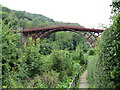
Iron bridge, Ironbridge
by Malc McDonald
geograph for square SJ6703
The iron bridge from which the village of Ironbridge is named. The bridge,... (more)
|
|
St Mary's Abbey remains: Precinct walls
by Jonathan Hutchins
geograph for square SE5952
Grade I listed. The telephone box in front is Grade II listed!
listing for... (more)
|
|
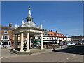
Chichester Cross
by PAUL FARMER
geograph for square SU8604
|
|
Berwick Bridge
by Jonathan Hutchins
geograph for square NT9952
The bridge was constructed between 1611 and 1624, and is Grade I listed, see... (more)
|
|
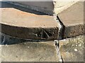
Benchmark, Carlisle Market Cross
by Adrian Taylor
for square NY4055
Detail of the Ordnance Survey pivot benchmark on the steps on the south west... (more)
|
|
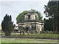
Trentham Mausoleum
by Jonathan Hutchins
for square SJ8641
This massive erection is said to be the only Grade I listed structure in the... (more)
|
|
Trentham Mausoleum
by Jonathan Hutchins
geograph for square SJ8641
This massive erection is said to be the only Grade I listed structure in the... (more)
|
|
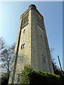
Sackville Water Tower Church Lane, East Grinstead
by PAUL FARMER
geograph for square TQ3938
The water tower is now converted into a home and is Grade II Listed
|
|
Covered bridge and boathouse
by Jonathan Hutchins
geograph for square ST8043
This structure is Grade I listed and dates from around 1807.
Listed building... (more)
|
|
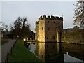
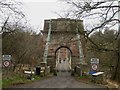
Gatehouse to Bishop's Palace, Wells
by Jonathan Hutchins
geograph for square ST5545
The fourteenth-century gatehouse, boundary wall and bridge are Grade I listed,... (more)
|
|
St. Peter and St. Paul Church Shoreham
by PAUL FARMER
geograph for square TQ5261
|
|
Buckingham Palace from Green Park
by PAUL FARMER
geograph for square TQ2979
|
|
Moat and gatehouse to the Bishop's Palace, Wells
by Jonathan Hutchins
geograph for square ST5545
The fourteenth-century gatehouse, boundary wall and bridge are Grade I listed,... (more)
|
|
Bladon Bridge during Blenheim Horse Trials
by Jonathan Hutchins
geograph for square SP4415
SsangYong is the title sponsor of Blenheim Horse Trials, hence the banners and... (more)
|
|
The Lion Bridge early on a September morning
by Jonathan Hutchins
for square TF0406
The Lion Bridge at Burghley is Grade I listed, see:... (more)
|
|
Grade I listed Galton Bridge, Smethwick
by Jaggery
geograph for square SP0189
Thomas Telford's 1829 bridge over the Birmingham Canal viewed from... (more)
|
|
Horseshoe sculptures by the River Glyme
by Jonathan Hutchins
geograph for square SP4415
The New Bridge of 1773 in the background is Grade I listed.
|

|
Plymouth Hoe, 1975
by FEG
geograph for square SX4753
The Hoe, seen from West Hoe. There are several listed structures in this view:... (more)
|
|
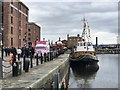
Hartley Quay
by Jonathan Hutchins
geograph for square SJ3489
The vessel alongside in Canning Half Tide Dock is motor tug... (more)
|
|
Grade I listed sundial, Blaise Hamlet, Bristol
by Jaggery
geograph for square ST5578
Located on the green in the middle of Blaise Hamlet, the sundial and pump date... (more)
|
|
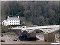
The English half of Chepstow Bridge
by David Lally
geograph for square ST5394
The bridge is grade I listed List entry Number: 1101561... (more)
|
|
Garden Lake, Stourhead
by Derek Harper
for square ST7733
Similar views are at Link . The... ( more) |
|
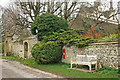
Postbox outside Manor House, Cold Ashton
by Derek Harper
geograph for square ST7572
|
|
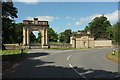
London lodge and gateway, Croome
by Derek Harper
geograph for square SO8844
There are a lot of other images of this scene, at... (more)
|
|
Buildings at Royal William Victualling Yard
by Derek Harper
geograph for square SX4653
A view from the Cremyll Ferry. On the left is the grade I listed Mills Bakery... (more)
|
|
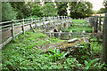
Twin bridges at Tilford
by Derek Harper
geograph for square SU8743
On the left is the grade I listed structure... (more)
|
|
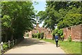
Approaching the Banqueting House, Hampton Court
by Derek Harper
geograph for square TQ1568
The Thames Path / Barge Walk / NCN4 approaching Hampton Court. The grade I... (more)
|
|
Gallox Bridge
by Derek Harper
geograph for square SS9843
Over the River Avill (flowing to the left), and also shown in most of the images... (more)
|
|
The Scottish end of the Union Chain Bridge
by Graham Robson
geograph for square NT9351
The Scottish end of the Union Chain Bridge. The concrete bollards in front of... (more)
|
|
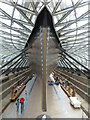
The Cutty Sark, Greenwich
by Chris Allen
for square TQ3877
Now raised from the floor of the dry dock to prevent distortion. The vessel is a... (more)
|
|
Obelisk, Stourhead
by Derek Harper
geograph for square ST7734
Behind trees on a gloomy day, seen from the Stour Valley Way. Clearer images of... (more)
|
|
St. Paul's Chapel, Stansted Park
by PAUL FARMER
geograph for square SU7510
|
|
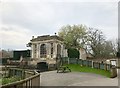
Rotondo, Stowe, 2000
by Derek Harper
geograph for square SP6737
"1721 by Vanbrugh. Dome added by Borra before 1763"... (more)
|
|
The Menai Suspension Bridge
by Jeff Buck
geograph for square SH5571
The Menai Suspension Bridge seen from the south (Bangor) side.
|
|
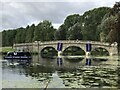
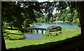
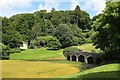
Palladian Bridge, Stourhead
by Derek Harper
geograph for square ST7733
Mapped as "The Stone Bridge". and also referred to as the "Five... (more)
|
![SE4824 : John Carr's Ferry Bridge, looking upstream [north] by Christine Johnstone](https://s3.geograph.org.uk/geophotos/04/55/77/4557743_be1987c8_120x120.jpg)
|
John Carr's Ferry Bridge, looking upstream [north]
by Christine Johnstone
geograph for square SE4824
Built to carry the Great North Road over the navigable River Aire. A Grade I structure.
|
|
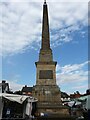
The Obelisk, Ripon Market Square
by Stephen Armstrong
for square SE3171
Grade I Listed, 1702. The earliest surviving free-standing monumental obelisk in... (more)
|
|
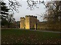
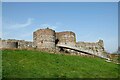
Beeston Castle, Cheshire
by Jeff Buck
geograph for square SJ5359
Beeston Castle has now re-opened again for the 2021 season. At present tickets... (more)
|
|
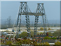
Newport Transporter Bridge
by Robin Drayton
for square ST3186
Viewed from Dickens Drive on the Gaer Estate... (more)
|
|
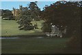
Palladian bridge and school, Stowe, 2000
by Derek Harper
geograph for square SP6837
The bridge dates from 1738... (more)
|