|
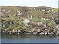
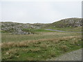
Standing stones on Great Bernera/Beàrnaraigh
by M J Richardson
geograph for square NB1634
Seen from across Sruth Iarsiadair. Part of the Calanais complex - Calanais VIII.
|
|
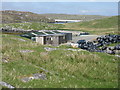
Mussel farm building at Iarsiadar
by M J Richardson
geograph for square NB1533
With the Bernera Bridge beyond, connecting the Isle of Lewis to Great Bernera/Beàrnaraigh.
|
|
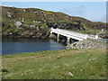
A bridge over the Atlantic
by M J Richardson
geograph for square NB1634
One of several that claim to span the Atlantic - this one joining Great... (more)
|
|
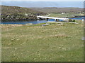
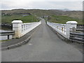
Bernera Bridge
by M J Richardson
geograph for square NB1634
Connecting Great Bernera/Beàrnaraigh to the Isle of Lewis, one of several... (more)
|
|
The road from Bostadh
by M J Richardson
geograph for square NB1340
Near the cul-de-sac by the cemetery and Iron Age Village, at the northern end of... (more)
|

|
Boats at Iarsiadar
by M J Richardson
geograph for square NB1533
Looking across Sruth Iarsiadar to Great Bernera/Beàrnaraigh from the mussel... (more)
|

|
Breakwater at Iarsiadar
by M J Richardson
geograph for square NB1533
Looking north, across Sruth Iarsiadar, to houses at Hacklete/Tacleit on Great... (more)
|
|
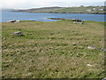
Rubha na h-Eubhaich
by M J Richardson
geograph for square NB1533
Looking northwest across Loch Ròg to Hacklete/Tacleit on Great Bernera/Beàrnaraigh
|
|
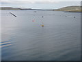
Mussel farm at Iarsiadar
by M J Richardson
geograph for square NB1634
To the east of the Bernara Bridge between Great Bernera/Beàrnaraigh and the Isle of Lewis.
|
|
Grazing at Earshader/Iarsiadar
by M J Richardson
for square NB1634
With the Bernera Bridge, and the sound separating Greater Bernera from the Isle of Lewis.
|
|
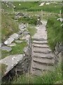
Steps at the Iron Age House
by M J Richardson
for square NB1340
Leading up from the underground entrance.
|
|
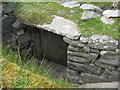
Iron Age House
by M J Richardson
for square NB1340
Underground doorway at the foot of the entrance steps. It is possible to go... (more)
|
|
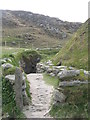
Entrance to the Iron Age House
by M J Richardson
geograph for square NB1340
A gap in the surrounding wall leads to the top of steps leading down to an... (more)
|
|
Iron Age House at Bostadh
by M J Richardson
for square NB1340
The inland end. Beyond is the path down from the car park.
|
|
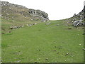
Bealach a' Sgail at Bostadh
by M J Richardson
geograph for square NB1339
Looking up the valley, the site of an Iron Age settlement. The footbridge... (more)
|
|
View from an Iron Age house
by M J Richardson
geograph for square NB1340
Looking over Traigh Bosdtadh to Camus Bostadh and Flodaigh, from the enclosure... (more)
|
|
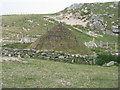
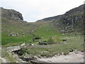
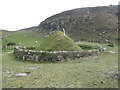
Iron Age Village at Bostadh
by M J Richardson
geograph for square NB1340
A reconstructed house and, farther up the valley, traces of other houses.
|
|
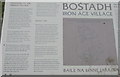
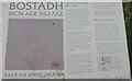
Information about Bostadh Iron Age Village
by M J Richardson
for square NB1340
The English version.
|
|
Information about Bostadh Iron Age Village
by M J Richardson
for square NB1340
The Gaelic version.
|
|
Bostadh Iron Age House
by M J Richardson
geograph for square NB1340
The reconstructed house, viewed looking south.
|
|
Low cloud over Great Bernera
by M J Richardson
geograph for square NB1832
A thin bank of cloud over the sea. Looking northeast from the B8059 near Lundale.
|
|
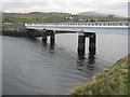
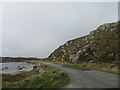
Coast at Bernera Bridge
by M J Richardson
geograph for square NB1634
With a steep launching ramp into Sruth Iarsiadair and Port a Chruidh.
|
|
Bernera Bridge
by M J Richardson
geograph for square NB1634
Looking south to the Isle of Lewis.
|
|
Road to Bostadh
by M J Richardson
geograph for square NB1539
Heading north between Loch Geal and a rocky outcrop of Cnoc na Cloiche Moire.
|
|
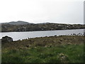
Loch Geal
by M J Richardson
for square NB1439
Looking west across the loch, one of many in the area.
|
|
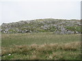
Cnoc Ruinagaidh
by M J Richardson
for square NB1440
A rocky out crop near the roadend at Bostadh.
|
|
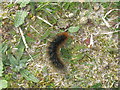
Garden Tiger Moth larva
by M J Richardson
for square NB1340
A larva of Arctia caja on the path close to the Iron Age house at Bostadh. Thin... (more)
|
|
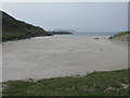
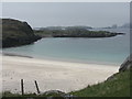
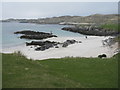
Beach at Bostadh
by M J Richardson
geograph for square NB1340
Looking across Camas Bostadh, with part of Flodaigh on the right.
|
|
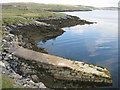
Rocky coast at Bostadh
by M J Richardson
geograph for square NB1340
Looking across Camas Bostadh from near the cemetery wall.
|
|
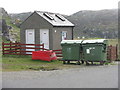
Public convenience at Bostadh
by M J Richardson
geograph for square NB1340
Near the end of the road at the cemetery and Iron Age Village.
|
|
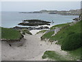
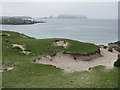
Poll a' Roin
by M J Richardson
geograph for square NB1340
A small sandy inlet off Traigh Bostadh; looking north from Cnoc a'... (more)
|

|
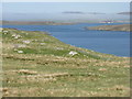
Traigh Bostadh
by M J Richardson
geograph for square NB1340
Looking across to Cnoc Urraman.
|
|
Camas Bostadh
by M J Richardson
geograph for square NB1340
Sand dunes at Bostadh, looking to a cloud-covered Flodaigh.
|