Public Tags
Tag: Harris
Other tags: place:Harris
Showing latest 50 of 89 images tagged with Harris tag.
|
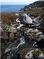
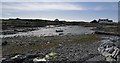
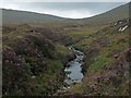
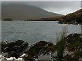
The Abhainn a' Ghlinne, Harris
by Claire Pegrum geograph for square NG2399 |
|
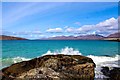
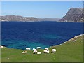
Taransay Island, Isle of Harris
by Adam Forsyth geograph for square NB0600 The Sound of Taransay and Isle of Taransay just off Luskentyre, Isle of Harris.... (more)
Tags:
top:CoastalX
top:Estuary, MarineX
type:GeographX
place:Harris
location:Isle of HarrisX
Na H-Eileanan an Iar/Outer HebridesX
country:ScotlandX
subject:SeaX
Sound of Taransay/Caolas TharasaighX
season:SpringX
island:TaransayX
Tropical WaterX
|
|
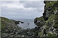
Bay, Renish Point/Rubha Reinis, Harris
by Claire Pegrum geograph for square NG0481 The Isle of Skye can be seen in the distance. The ground to the right of the... (more)
|
|
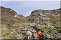
Bulabhall, Harris
by Rude Health geograph for square NG0593 Dropped off by Jim Bloomer at new bridge to east to bag my fourth HuMP as I... (more)
|
|
Heileasbhal Mòr, Harris
by Rude Health geograph for square NG0792 Dropped off by Jim Bloomer at new bridge to east to bag my 3rd of 4 HuMPs as I... (more)
|
|
An Coileach, Harris
by Rude Health geograph for square NG0892 Dropped off by Jim Bloomer at new bridge to east to bag four HuMPs, this was the... (more)
|
|
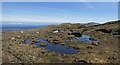
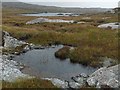
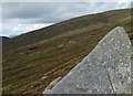
Boggy pools on the eastern slopes of Bleabhal, Harris
by Claire Pegrum geograph for square NG0391 Looking towards Roineabhal, the highest point in south Harris.
|
|
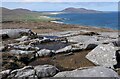
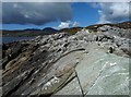
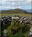
Rocks and pools on Cleit Niosaboist, Harris
by Claire Pegrum geograph for square NG0495 Looking towards the beaches of west Harris and Ceapabhal.
|
|
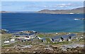
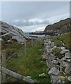
Talla na Mara, Harris
by Claire Pegrum geograph for square NG0396 Talla na Mara, which means centre by the sea, is a West Harris Trust community... (more)
Tags:
Affordable HousingX
Business UnitsX
top:Business, Retail, ServicesX
top:CoastalX
Community Arts CentreX
Community HallX
Community ProjectX
type:GeographX
place:Harris
top:Housing, DwellingsX
top:IslandsX
top:MoorlandX
top:Sport, LeisureX
Tourist FacilityX
subject:ViewX
|
|
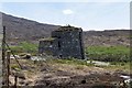
The Broch, Borve Lodge Estate, Harris
by Claire Pegrum geograph for square NG0395 The Broch is a holiday cottage which was completed in 2012. The design is based... (more)
Tags:
type:GeographX
place:Harris
Holiday CottageX
subject:HouseX
top:Housing, DwellingsX
top:MoorlandX
place:South HarrisX
|
|
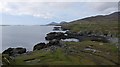
Coastline, Rubha Reinis/Renish Point, Harris
by Claire Pegrum geograph for square NG0382 Looking towards Ceapabhal and Grèabhal.
|
|
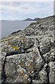
Coastline, Rubha Reinis/Renish Point, Harris
by Claire Pegrum geograph for square NG0381 Looking towards Ceapabhal and Grèabhal.
|
|
Bàigh Chàirminis/Cairminis Bay, Harris
by Claire Pegrum geograph for square NG0284 The OS Name Book says that the name Carminish (as it was recorded at that time)... (more)
|
|
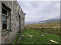
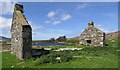
Ruined croft house, Cul na h-Àird, Harris
by Claire Pegrum geograph for square NB1202 Looking along Loch a' Siar towards the mountains of North Harris.
|
|
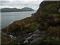
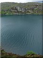
Unnamed burn below Creag na h-Iolaire, Harris
by Claire Pegrum geograph for square NB2009 Looking along Loch Seaforth/Loch Shiphoirt which forms the boundary between... (more)
|
|
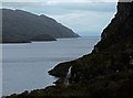
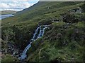
Waterfall below Creag na h-Iolaire, Harris
by Claire Pegrum geograph for square NB2009 Looking along Loch Seaforth/Loch Shiphoirt which forms the boundary between... (more)
|
|
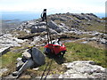
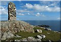
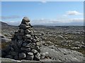
Cairn, Àird Mhòr, Harris
by Claire Pegrum geograph for square NG1088 Looking across The Minch towards Skye.
The cairn is one of two on this... (more)
|
|
Cairn, Àird Mhòr, Harris
by Claire Pegrum geograph for square NG1188 Looking across The Minch towards Skye.
The cairn is one of two on this... (more)
|
|
Lazy beds above Mol nan Stòp, Harris
by Claire Pegrum geograph for square NB0700 Looking across Loch a Siar towards the peaks of North Harris. The highest peak... (more)
|
|
Shielings, South Harris
by Claire Pegrum geograph for square NG0790 These are part of a group of four shielings and another lies next to the unnamed... (more)
Tags:
top:Derelict, DisusedX
top:Farm, Fishery, Market GardeningX
type:GeographX
place:Harris
top:Housing, DwellingsX
top:IslandsX
subject:ShelterX
ShielingsX
place:South HarrisX
top:UplandsX
|
|
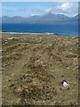
Cairn on rocky moorland, South Harris
by Claire Pegrum geograph for square NG0890 |
|
The Uisg a' Ri, Tarcall, Harris
by Claire Pegrum geograph for square NB0901 Looking across Loch a' Sair towards the mountains of North Harris.
|
|
Tartur Geo, Tarcall, Harris
by Claire Pegrum geograph for square NB0801 Looking towards the skerry, Sgeir Tarcall, and beyond to the mountains of North Harris.
Tags:
top:CoastalX
top:Estuary, MarineX
subject:Geo (Inlet)X
type:GeographX
place:Harris
top:IslandsX
top:Rocks, Scree, CliffsX
SkerryX
|
|
Ceann Reamhar na Sroine, Harris
by Rude Health geograph for square NG0993 Dropped off by Jim Bloomer at new bridge to east to bag four HuMPs as I walked... (more)
|
|
Outflow from Loch Chumain, Harris
by Claire Pegrum geograph for square NG1692 The buoy is from a boat called Spindrift, possibly SY128, a Stornoway registered... (more)
|
|
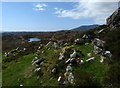
Exposed rock, Bràigh Buidhe, Harris
by Claire Pegrum geograph for square NG0292 NG0294 : Traigh Mhor, Scarasta can just be seen on the right and the island is the western side of... (more)
|
|
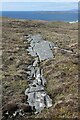
Dyke, Meabhal, Harris
by Claire Pegrum geograph for square NG0291 The dyke is shown on OS maps with a scale of 1:25,000 and larger.
|
|
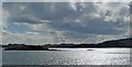
Mol Bhi, Harris
by Claire Pegrum geograph for square NG1691 Mol Bhi (or Mol Vee) is an inlet on Loch Ghreosabhagh.
|
|
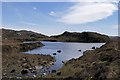
Lochan on moorland below Bulabhall, Harris
by Claire Pegrum geograph for square NG0493 |
|
Ruined house above Loch Bhuirgh, Harris
by Claire Pegrum geograph for square NG0494 At the time of uploading, the building is shown as roofed on OS maps.
|
|
Creag a' Chais, Eilean Shìophoirt, Harris
by Claire Pegrum geograph for square NB2010 The OS Name Book of 1848-1852 states that Creag a' Chais means Cheese Rock... (more)
|
|
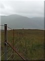
Fence, Gleann Uachdrach, Harris
by Claire Pegrum geograph for square NG0090 Looking towards Beinn Tharsuinn and Bhoiseabhal.
|
|
The Abhainn Horsa-cleit, Harris
by Claire Pegrum geograph for square NG0190 Looking towards the bealach between Bolabhal Sgarasta and Cleite Dhomhnaill.
|
|
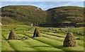
Hay drying on lazy beds, Cuidhtinis, Harris
by Claire Pegrum geograph for square NG0887 Disused lazy beds can be seen on the hillside opposite.
|
|
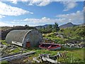
Boat builder, Fleoideabhagh, Harris
by Claire Pegrum geograph for square NG0989 Looking towards An Coileach.
The boat builder is situated by the C79... (more)
|
|
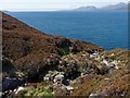
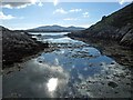
Inlet on Loch Fhleoideabhaigh, Harris
by Claire Pegrum geograph for square NG1088 The nearest land visible across the loch is Glas Sgeir, a skerry, which lies... (more)
|
|
Loch Loch Langabhat, Harris
by Claire Pegrum geograph for square NG0490 Looking towards Bleabhal.
|
|
Moorland pool to the east of Loch Langabhat, Harris
by Claire Pegrum geograph for square NG0589 Looking towards Loch Dubh Shleiteabhal, which is the name on the OS 1:50,000... (more)
|
|
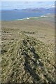
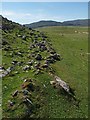
Fence and dyke above coastline near Cuidhtinis, Harris
by Claire Pegrum geograph for square NG1087 Both the fence and remaining section of the dyke are shown running alongside... (more)
|
|
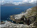
Rock, Àird Mhòr, Harris
by Claire Pegrum geograph for square NG1289 Looking towards Loch Gheocrab. The tallest hill on the horizon is An Coileach.
|
|
Rock on the western slopes of Ceann Reamhar, Harris
by Claire Pegrum geograph for square NG1198 |
|
Waterfall on the Abhainn Scrien, Gleann Lacasdail, Harris
by Claire Pegrum geograph for square NB1703 Looking towards Lochannan Lacasdail and the eastern slopes of Sròn an Toistear.
|
|
Gloraig Dhubh, Loch an Tairbeairt, Harris
by Claire Pegrum geograph for square NG1895 The northern (right hand) tip of Gloraig Dhubh, the larger skerry, and the whole... (more)
|
|
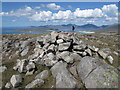
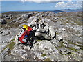
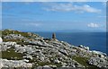
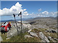
Triangulation pillar, Ceann Reamhar, Harris
by Claire Pegrum geograph for square NG1199 Looking towards Beinn Dhubh.
The western boundary of the grid square runs... (more)
|
|
Ruined building, Àird Grothadnais, Harris
by Claire Pegrum geograph for square NB0601 The building lies adjacent to the field bounded by the wall shown at NB0601 : Ancient wall and Beinn Dubh.
|
|
Grazing sheep, Meilein, Harris
by Claire Pegrum geograph for square NB0014 Lazy beds can just be made out going from the bottom edge of the photo towards... (more)
|
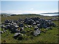
|
Ruined dyke below Grescleit, Harris
by Claire Pegrum geograph for square NA9913 Looking towards the hills of Scarp.
Described at... (more)
|
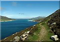
|
View from the path between Huisinis and Crabhadail, Harris
by Claire Pegrum geograph for square NA9912 Looking along Caolas an Scarp (Scarp Narrows) towards Scarp (left), Eilean... (more)
|
|
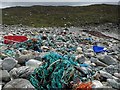
Flotsam and jetsam, Bàgh Theilisnis, Harris
by Claire Pegrum geograph for square NB1104 Looking towards Àird Chathanais.
|
|
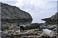
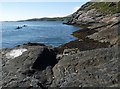
Coastline near Leabaidh a' Mhèirlich, Harris
by Claire Pegrum geograph for square NB0705 |