Public Tags
Tag: Harter·Fell
Other tags: place:Harter Fell
Showing latest 50 of 76 images tagged with Harter Fell tag.
|
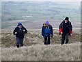
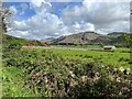
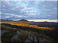
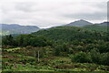
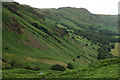
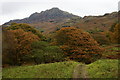
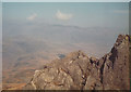
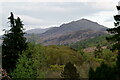
Triple HuMP Hall Of Fame Entry On Harter Fell
by Rude Health geograph for square NY7200 Chris Watson, Jonathan Woods and Chris Bienkowski detour to the east of Harter... (more)
Tags:
DeweyX
top:GrasslandX
Harter Fell
HuMPX
HuMP Hall Of FameX
P120X
top:People, EventsX
top:UplandsX
|
|
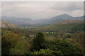
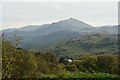
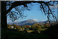
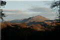
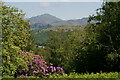
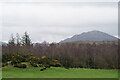
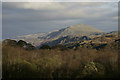
View Towards Harter Fell
by Peter Trimming for square SD1399 Harter Fell is towards the right of picture, with the Hardknott Pass in the dip... (more)
Tags:
county:CumbriaX
place:Eskdale GreenX
type:ExtraX
Harter Fell
subject:ViewX
top:Village, Rural SettlementX
top:Woodland, ForestX
|
|
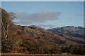
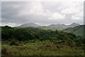
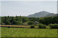
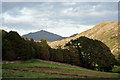
View Towards Harter Fell
by Peter Trimming geograph for square SD1398 Harter Fell is the peak towards the left of picture.
Tags:
county:CumbriaX
place:Eskdale GreenX
type:GeographX
Harter Fell
top:MoorlandX
top:Rocks, Scree, CliffsX
subject:ViewX
|
|
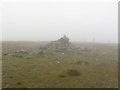
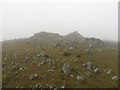
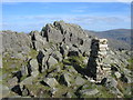
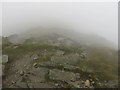
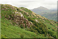
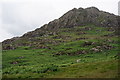
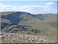
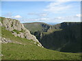
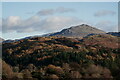
The summit of Harter Fell
by Graham Robson geograph for square NY4509 The highest point of Harter Fell is marked by a rough cairn on a relatively flat... (more)
|
|
Cairn on Harter Fell
by Graham Robson geograph for square NY4609 A loosely built cairn and shelter located to the east of the highest point on Harter Fell.
|
|
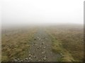
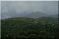
Climbing towards the top of Harter Fell
by Graham Robson geograph for square NY4609 The path disappearing into cloud and towards the top of Harter Fell. The path... (more)
|
|
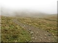
Path approaching the top of Little Harter Fell
by Graham Robson geograph for square NY4609 Approaching the summit of Little Harter Fell with visibility restricted to a... (more)
|
|
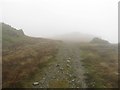
Path climbing Harter Fell
by Graham Robson geograph for square NY4709 The stony path climbing towards the peak of Harter Fell. The summit is hidden in... (more)
|
|
View Towards Harter Fell
by Peter Trimming geograph for square SD1399 I had the opportunity to access private land, to the north-west of Forest How,... (more)
Tags:
place:Eskdale ValleyX
Forest HowX
Harter Fell
Private Farm LandX
top:Rocks, Scree, CliffsX
top:UplandsX
top:Woodland, ForestX
|
|
Harter Fell, Eskdale
by Rude Health geograph for square SD2199 Parked in Dunnerdale Forest car park to east and came up direct route.
Name:... (more)
|

|
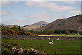
View Towards Harter Fell, Cumbria
by Peter Trimming geograph for square NY1400 One of the clearest views of Harter Fell, seen from the Ravenglass & Eskdale Railway.
Tags:
county:CumbriaX
EskdaleX
top:Farm, Fishery, Market GardeningX
top:GrasslandX
Harter Fell
top:LowlandsX
Ravenglass Eskdale RailwayX
|
|
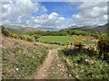
Track near Rabbit How
by Adrian Taylor geograph for square SD1399 The track is a public footpath from Eskdale Green to Muncaster. The fields and... (more)
Tags:
BowfellX
CumberlandX
CumbriaX
EskdaleX
FellsX
type:GeographX
GorseX
Gorse in FlowerX
Green CragX
Hardknott PassX
Harter Fell
top:Heath, ScrubX
Lake DistrictX
Lakeland FellsX
place:Rabbit HowX
top:Roads, Road TransportX
Sca FellX
Stony TrackX
The Lake District National ParkX
subject:TrackX
top:UplandsX
|
|
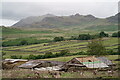
High Ground Farm
by Peter Trimming geograph for square SD1798 The public footpath has been re-routed to the west of the farm. A new roof is... (more)
Tags:
Birker FellX
county:CumbriaX
top:Farm, Fishery, Market GardeningX
type:GeographX
Harter Fell
farm:High Ground FarmX
top:MoorlandX
top:Village, Rural SettlementX
|
|
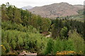
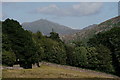
Eskdale from near Birks Coppice
by Adrian Taylor geograph for square SD1398 The rocky fell near the centre of the photograph is Brantrake Crags; the... (more)
Tags:
Brantrake CragsX
CumberlandX
CumbriaX
EskdaleX
type:GeographX
top:GrasslandX
Harter Fell
Lake DistrictX
top:LowlandsX
top:Rocks, Scree, CliffsX
The Lake District National ParkX
top:UplandsX
subject:ValleyX
|
|
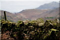
Wall at Birks Coppice
by Peter Trimming geograph for square SD1398 A small triangle of woodland bounded by a track and the wall, with fields beyond... (more)
Tags:
county:CumbriaX
place:Eskdale GreenX
type:GeographX
Harter Fell
top:Rocks, Scree, CliffsX
WallX
top:Woodland, ForestX
|
|
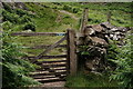
Gate to the Fells
by Peter Trimming geograph for square NY2000 On the path up from Eskdale, towards the Duddon Valley. Harter Fell lies to the... (more)
|
|
Descending towards the Nan Bield Pass
by Graham Robson geograph for square NY4509 Looking down a steep section of the path between Harter Fell's summit and... (more)
|
|
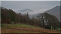
Sunset, Eskdale Fell
by Michael Graham geograph for square NY1903 Looking towards Harter Fell
Tags:
top:Air, Sky, WeatherX
Harter Fell
top:Lakes, Wetland, BogX
top:Rocks, Scree, CliffsX
SunsetX
top:UplandsX
Wild CampingX
|
|
View Towards Harter Fell
by Peter Trimming geograph for square NY1500 Seen from the fell, above Fisherground. Hollinghead Crag is in the foreground.
Tags:
county:CumbriaX
place:Eskdale ValleyX
FishergroundX
Harter Fell
Hollinghead CragX
top:MoorlandX
top:Rocks, Scree, CliffsX
top:UplandsX
|
|
View Towards Harter Fell, Cumbria
by Peter Trimming geograph for square NY1400 Seen from the fells, above Fisherground.
|
|
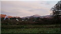
Eskdale Green
by Peter Trimming geograph for square SD1399 Evening view, towards Harter Fell.
Tags:
county:CumbriaX
place:Eskdale GreenX
type:GeographX
Harter Fell
top:Village, Rural SettlementX
|
|
View Towards Harter Fell
by Peter Trimming geograph for square SD1399 Looking across Forge Wood.
|
|
View Towards Harter Fell
by Peter Trimming geograph for square SD2099 Seen from the path which links Eskdale and the Duddon Valley.
|
|
Harter Fell
by Michael Graham geograph for square NY1903 Zoom shot over Winscales at sunset
Tags:
Harter Fell
top:Lakes, Wetland, BogX
top:Rocks, Scree, CliffsX
SunsetX
top:UplandsX
Wild CampingX
|
|
Evening in Eskdale
by Peter Trimming geograph for square SD1399 View from the footpath to the south of Forest How. Harter Fell is to the extreme... (more)
|
|
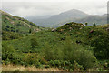
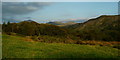
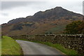
Hardknott Pass
by Peter Trimming geograph for square NY2101 Looking into Eskdale, from close to the Roman fort. On the left of picture are... (more)
|
|
Miterdale Forest
by Peter Trimming geograph for square NY1301 Following larch clearance, the view towards Harter Fell has been opened up.
Tags:
county:CumbriaX
subject:ForestX
Harter Fell
Miterdale ForestX
top:UplandsX
top:Woodland, ForestX
|
|
View Towards Harter Fell
by Peter Trimming geograph for square NY1600 Seen across Blea Tarn.
|
|
View Towards Harter Fell, Eskdale, Cumbria
by Peter Trimming geograph for square NY1900 Seen from the road with runs down into Eskdale.
Tags:
place:CumbriaX
EskdaleX
Harter Fell
top:Roads, Road TransportX
top:Rocks, Scree, CliffsX
top:UplandsX
|
|
View Towards Harter Fell, Cumbria
by Peter Trimming geograph for square NY1900 Photographed from the bridleway which runs from Doctor Bridge to Whahouse Bridge.
|
|
View Towards Harter Fell, Cumbria
by Peter Trimming geograph for square SD1399 Seen from the track which runs south from the Irton Road railway station.
|
|
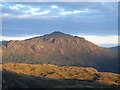
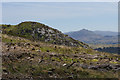
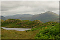
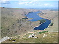
Haweswater from Cairn on Harter Fell
by Robert Skipworth for square NY4712 The cairn is NE of the summit before the path descends to Gatesgarth Pass.
|
|
High Street and Blea Water from Harter Fell
by Robert Skipworth for square NY4509 |
|
Summit of Harter Fell
by Stephen Craven geograph for square SD2199 A view down to the Hardknott Pass.
|
|
View Towards Harter Fell
by Peter Trimming for square SD1399 Seen late in the afternoon.
Tags:
county:CumbriaX
place:Eskdale GreenX
type:ExtraX
Harter Fell
top:Rocks, Scree, CliffsX
subject:ViewX
|
|
Summit crags, Kidsty Pike
by Adrian Taylor geograph for square NY4412 Looking across Riggindale to Harter Fell with Mardale Ill Bell on the right.
Tags:
county:CumbriaX
type:GeographX
Harter Fell
Kidsty PikeX
Lake DistrictX
Mardale Ill BellX
subject:MountainX
RiggindaleX
top:Rocks, Scree, CliffsX
The Lake District National ParkX
top:UplandsX
|
|
Eskdale
by Peter Trimming geograph for square SD1399 View towards the distant Harter Fell.
Tags:
county:CumbriaX
place:Eskdale GreenX
place:Eskdale ValleyX
type:GeographX
Harter Fell
top:Rocks, Scree, CliffsX
subject:ViewX
top:Woodland, ForestX
|
|
View Towards Harter Fell
by Peter Trimming geograph for square SD1399 Seen from Access Land, to the northwest of Forest How.
Tags:
county:CumbriaX
place:Eskdale ValleyX
type:GeographX
Harter Fell
top:Rocks, Scree, CliffsX
subject:ViewX
top:Woodland, ForestX
|
|
Church House
by Peter Trimming geograph for square NY1700 On the outskirts of the village of Boot, with Harter Fell in the background.
Tags:
place:BootX
county:CumbriaX
top:Farm, Fishery, Market GardeningX
type:GeographX
top:GrasslandX
Harter Fell
top:Rocks, Scree, CliffsX
top:Village, Rural SettlementX
top:Woodland, ForestX
|
|
View up Eskdale
by Peter Trimming for square SD1399 Storm over Harter Fell, with rumbles of thunder in both Eskdale and the Duddon... (more)
Tags:
top:Air, Sky, WeatherX
county:CumbriaX
place:Eskdale GreenX
type:ExtraX
place:Harter Fell
top:Rocks, Scree, CliffsX
top:Woodland, ForestX
|
|
View Towards Harter Fell
by Peter Trimming geograph for square SD1398 Seen from the Esk Trail, close to Muncaster Head.
Tags:
county:CumbriaX
place:Eskdale GreenX
top:Farm, Fishery, Market GardeningX
type:GeographX
top:GrasslandX
place:Harter Fell
top:Rocks, Scree, CliffsX
subject:ViewX
|
|
View Towards Harter Fell
by Peter Trimming geograph for square SD1399 Seen, in the evening light, from Forest How.
Tags:
county:CumbriaX
place:Eskdale GreenX
type:GeographX
place:Harter Fell
top:Rocks, Scree, CliffsX
subject:ViewX
top:Woodland, ForestX
|
|
View Towards Brantrake
by Peter Trimming geograph for square SD1298 Harter Fell is in the distance.
Tags:
Brantrake CragsX
county:CumbriaX
place:Eskdale ValleyX
type:GeographX
place:Harter Fell
top:Rocks, Scree, CliffsX
subject:ViewX
top:Woodland, ForestX
|
|
Eskdale
by Peter Trimming geograph for square SD1398 View towards Harter Fell, on a misty afternoon.
Tags:
county:CumbriaX
place:Eskdale GreenX
top:Farm, Fishery, Market GardeningX
type:GeographX
Harter Fell
subject:ViewX
top:Woodland, ForestX
|
|
Harter Fell
by Peter Trimming for square SD2199 Seen from Eskdale Green. To the extreme left of picture, two cars can be seen on... (more)
Tags:
type:Cross GridX
county:CumbriaX
place:Eskdale GreenX
Harter Fell
top:Rocks, Scree, CliffsX
top:Woodland, ForestX
|
|
Eskdale Green
by Peter Trimming geograph for square SD1399 View towards Bankend Wood, in the foreground, with Harter Fell in the distance.
Tags:
county:CumbriaX
place:Eskdale GreenX
type:GeographX
top:GrasslandX
Harter Fell
subject:ViewX
top:Woodland, ForestX
|
|
View Towards Harter Fell
by Peter Trimming geograph for square SD1398 Seen from the Esk Trail.
Tags:
county:CumbriaX
place:Eskdale GreenX
type:GeographX
Harter Fell
top:Rocks, Scree, CliffsX
top:Woodland, ForestX
|
|
Eskdale
by Peter Trimming geograph for square SD1398 View towards Harter Fell, from the Esk Trail near Horse Parks.
Tags:
county:CumbriaX
place:Eskdale ValleyX
type:GeographX
top:GrasslandX
Harter Fell
subject:ViewX
top:Woodland, ForestX
|
|
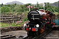
'River Mite'
by Peter Trimming geograph for square NY1700 Seen on the turntable at Dalegarth, awaiting the departure of another service... (more)
Tags:
county:CumbriaX
place:Dalegarth StationX
place:Eskdale ValleyX
type:GeographX
Harter Fell
top:RailwaysX
Ravenglass & Eskdale RailwayX
River MiteX
top:Sport, LeisureX
top:Village, Rural SettlementX
|
|
View Towards Harter Fell
by Peter Trimming geograph for square SD1399 Seen from the paddock at Forest How. The squirrels will enjoy this view from the... (more)
Tags:
county:CumbriaX
place:Eskdale GreenX
Forest HowX
type:GeographX
Harter Fell
top:Rocks, Scree, CliffsX
subject:ViewX
top:Woodland, ForestX
|