Public Tags
Tag: Islamic·Centre
Showing images tagged with Islamic Centre tag.
|
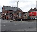
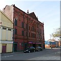
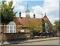
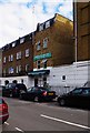
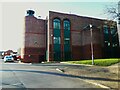
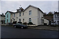
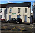
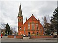
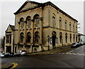
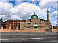
Hazrat Shahjahal Mosque and Bangladesh Islamic Centre, Swindon
by Jaggery geograph for square SU1585 The mosque and Islamic centre was established in 1999.
|
|
Dar al-Islam Foundation, Cricklewood, London NW2
by Jaggery geograph for square TQ2385 Located at 61 Anson Road, on the corner of Chichele Road.
Dar al-Islam is... (more)
|
|
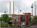
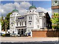
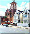
Greenwich Islamic Centre
by Stephen Craven geograph for square TQ4478 Category: Islamic centre One of the main centres of Islamic worship and teaching in south-east London.
Tags:
Islamic Centre
top:Religious SitesX
|
|
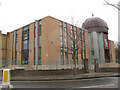
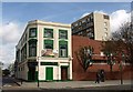
Bait-ul-Aziz Islamic Cultural Centre
by Stephen Craven geograph for square TQ3279 Category: Islamic centre This Islamic centre is on Harper Road, Southwark. See also TQ3279 : Bait-ul-Aziz Islamic Cultural Centre (2).
|
|
Hyde Islamic Resource Centre Masjid at Tawheed
by Gerald England geograph for square SJ9494
Hyde Theatre Royal opened on 3rd November 1902. A cinema was added in 1911.... (more)
Tags:
date:1902X
date:1911X
date:1972X
date:1992X
Cinema (Former)X
type:GeographX
Grade II ListedX
Islamic Centre
top:Religious SitesX
top:Sport, LeisureX
former:TheatreX
|
|
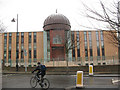
Islamic Centre of England, Maida Vale
by David Dixon geograph for square TQ2583 Islamic education centre on Maida Vale. Founded in December 1995 and opened... (more)
Tags:
top:Educational SitesX
IslamX
Islamic Centre
camera:Panasonic DMC-G3X
top:Religious SitesX
top:Suburb, Urban FringeX
|
|
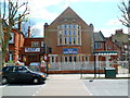
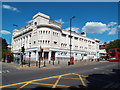
The Hippodrome, Golders Green
by Malc McDonald geograph for square TQ2587 The Hippodrome in Golders Green is a Grade II listed building. It opened as a... (more)
Tags:
type:GeographX
place:Golders GreenX
Grade II ListedX
Grade II Listed BuildingX
subject:HallX
Islamic Centre
Islamic Cultural CentreX
place:London NW11 (Golders Green)X
former:Music HallX
building type:Music HallX
Music Hall (Former)X
former:Music VenueX
place:North West LondonX
top:Religious SitesX
|
|
Bait-ul-Aziz Islamic Cultural Centre (2)
by Stephen Craven geograph for square TQ3279 Category: Islamic centre The centre is on the corner of Brockham Street (foreground) and Harper Road.... (more)
Tags:
Islamic Centre
top:Religious SitesX
|
|
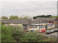
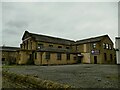
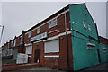
The Doric Centre, Kellner Road, Thamesmead
by Stephen Craven geograph for square TQ4579 A number of businesses seem to be registered at this address as well as both... (more)
|
|
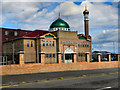
Brent Mosque and Islamic Centre, Chichele Road, London NW2
by Jaggery geograph for square TQ2385 This is the Chichele Road side of the building.
The main entrance is from the... (more)
|
|
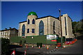
Belfast Islamic Centre, Southall
by Stephen Craven for square TQ1180 The golden dome of this building, seen from the nearby canal and apparently near... (more)
|
|
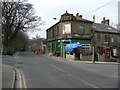
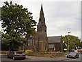
Epsom Islamic Centre
by Ian Capper geograph for square TQ2061 Mosque in Hook Road, seen from Miles Road. The building was originally the... (more)
Tags:
top:CommunicationsX
place:EpsomX
mosque:Epsom Islamic CentreX
type:GeographX
road:Hook RoadX
Islamic Centre
road:Miles RoadX
MosqueX
top:Religious SitesX
top:Suburb, Urban FringeX
Victorian PostboxX
VR PostboxX
|
|
School to Synagogue to Islamic Centre
by Des Blenkinsopp geograph for square TQ4488 It still says Infants School on the gate, but this building in Ferrymans Farm... (more)
|
|
Dawat Ul Islam Masjid
by David Dixon geograph for square SD5817 Mosque at the corner of Charnock Street and Brooke Street.
|
|
Masjid-e Noorul Islam, Higher Audley
by David Dixon geograph for square SD6927 Mosque on Audley Range, Blackburn. The mosque opened in July 2010, see... (more)
|
|
Masjid-e Noorul Islam
by David Dixon geograph for square SD6927 Mosque on Audley Range, Blackburn. The mosque opened in July 2010, see... (more)
|
|
Euston Mosque, Starcross Street, Camden, London
by P L Chadwick geograph for square TQ2982 As well as the mosque, according to the signage outside, also based here is... (more)
|
|
Shop being converted to Islamic centre
by Humphrey Bolton geograph for square SE1435 This building has BPISLd carved in stone, possibly Bradford Provident Insurance... (more)
|
|
Pakistan Social Cultural and Islamic Centre
by Jonathan Thacker geograph for square SE8911 The first mosque visited by the Queen in this country. The occasion was her... (more)
|
|
Leeds Islamic Centre (2)
by Stephen Craven geograph for square SE3135 The modern place of worship and cultural centre built in 2001 replaced a few... (more)
|
|
Leeds Islamic Centre (1)
by Stephen Craven geograph for square SE3135 The modern place of worship and cultural centre built in 2001 replaced a few... (more)
|
|
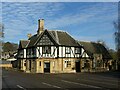
Fiveways Centre
by Alan Murray-Rust geograph for square SK5743 This former pub has been converted to an Islamic community and education centre.... (more)
Tags:
date:1937X
Black and White ArchitectureX
top:Educational SitesX
type:GeographX
Grade II ListedX
Islamic Centre
period:Mid 20th CenturyX
former:Public HouseX
top:Religious SitesX
top:Suburb, Urban FringeX
|
|
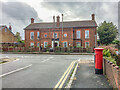
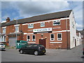
Horncastle Road, Boston, Lincs
by David Hallam-Jones geograph for square TF3344 The Boston Mosque and Islamic Centre has been situated in a local-style building... (more)
Tags:
subject:HouseX
top:Housing, DwellingsX
Islamic Centre
MosqueX
top:Religious SitesX
top:Suburb, Urban FringeX
|
|
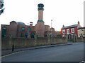
Witton Islamic Centre, 311-313 Witton Road, Aston, Birmingham
by P L Chadwick geograph for square SP0790 This part of Birmingham has a significant number of residents who are Muslim.... (more)
|
|
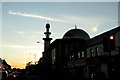
Evening on Oxford Road
by Steve Daniels geograph for square SU6973 The Abu Bakr Islamic Centre is silhouetted against the evening sky.
Tags:
Islamic Centre
top:Religious SitesX
|
|
Masjid at Tawheed
by Gerald England geograph for square SJ9494 Onward Chambers on Onward Street (as opposed to Onward Chambers on Market... (more)
Tags:
Islamic Centre
top:Religious SitesX
|
|
South Norwood Islamic Centre
by N Chadwick geograph for square TQ3468 Tags:
Islamic Centre
top:Religious SitesX
|
|
Former Green Man Pub, Otley Road, Undercliffe, Bradford
by Stephen Armstrong geograph for square SE1734 Google Street View shows it as still a pub in August 2022. Currently being... (more)
Tags:
top:Business, Retail, ServicesX
Former Public HouseX
type:GeographX
Islamic Centre
top:Religious SitesX
top:Suburb, Urban FringeX
|
|
Torbay Islamic Centre
by Ian S geograph for square SX9064 On Avenue Road, Torquay.
|
|
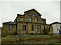
Umm-ul-Qura Islamic Centre, Leeds Road - east side
by Stephen Craven geograph for square SE1833 Formerly Greenhill Methodist Church, there is a date of 1928 on the building at... (more)
|
|
Umm-ul-Qura Islamic Centre, Leeds Road - front
by Stephen Craven for square SE1833 Formerly Greenhill Methodist Church, there is a date of 1928 on the building at... (more)
|
|
Minhaj Ul Quran Islamic Cultural Centre, #187 Manningham Lane
by Roger Templeman geograph for square SE1534 There is an Ordnance Survey benchmark SE1534 : Benchmark on Drill Parade face of #187 Manningham Lane on a stone to the right of the... (more)
|
|
West Wales Islamic Cultural & Educational Centre, Carmarthen
by Jaggery geograph for square SN4120 At 131 Priory Street alongside the A484.
|
|
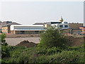
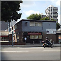
Islamic Centre on Parkinson Avenue, Scunthorpe
by Ian S geograph for square SE8911 |
|
St John's, Longsight
by Gerald England geograph for square SJ8695
The former Church of St. John the Apostle and Evangelist was founded in 1846.... (more)
Tags:
date:1846X
date:1979X
date:1993X
former:Anglican ChurchX
type:GeographX
Islamic Centre
place:LongsightX
top:Religious SitesX
|
|
St John's, Longsight
by Gerald England geograph for square SJ8695
The former Church of St. John the Apostle and Evangelist was founded in 1846.... (more)
Tags:
date:1846X
date:1979X
date:1993X
former:Anglican ChurchX
type:GeographX
Islamic Centre
place:LongsightX
top:Religious SitesX
|
|
Didsbury Mosque
by Gerald England geograph for square SJ8391 The former Albert Park Methodist Church, on the corner of Barlow Moor Road and... (more)
Tags:
date:1883X
date:1962X
date:1967X
Bell TowerX
type:GeographX
Gothic StyleX
Islamic Centre
former:Methodist ChurchX
MosqueX
top:Religious SitesX
|
|
Keele University: Islamic Centre
by Jonathan Hutchins geograph for square SJ8145 Tags:
top:Educational SitesX
Islamic Centre
subject:Religious SiteX
top:Religious SitesX
University of KeeleX
|
|
Islamic Centre on St Stephens Road, Huddersfield
by Ian S geograph for square SE1315 |
|
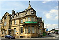
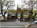
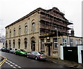
Victoria Road side of a Grade II Listed building, Newport
by Jaggery geograph for square ST3187 Now (January 2015) the premises of the Islamic Society for Wales, this building... (more)
|
|
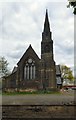
Grade II listed former Victoria Road United Reformed Church, Newport
by Jaggery geograph for square ST3187 The distinctive building is strikingly sited on the corner of Victoria Road and... (more)
|
|
Camberwell Islamic Centre, Camberwell Road
by Robin Stott geograph for square TQ3277 Part of a two-storey mixed development at the feet of the Castlemead slab block,... (more)
Tags:
place:CamberwellX
road:Camberwell RoadX
top:Health and Social ServicesX
Islamic Centre
place:LondonX
top:LowlandsX
top:Religious SitesX
postcode area:SE5X
top:Suburb, Urban FringeX
|
|
Old Kent Road Mosque
by Derek Harper geograph for square TQ3378 The Old Kent Road Mosque & Islamic Cultural Centre is on the corner of... (more)
|
|
Church of St John the Apostle and Evangelist
by David Dixon geograph for square SJ8695 The Church of St John the Apostle and Evangelist is on the corner of Holmfirth... (more)
|
|
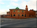
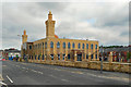
"Bolton Mosque", Masjid-e-Noor-Ul-Islam
by David Dixon geograph for square SD7110 The large mosque (masjid) at the corner of Prospect Street and Halliwell Road, Bolton.
|
|
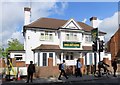
The Ahlul Bayt Centre on Oxford Road
by Steve Daniels geograph for square SP5304 The centre is in the former Exeter Hall pub.
|
|
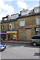
Shops with flats above on Toller Lane
by Roger Templeman geograph for square SE1434 There is an Ordnance Survey benchmark SE1434 : Benchmark on #143 Toller Lane (Babu Fabrics) to the right of the cable... (more)
|
|
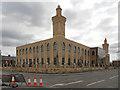
Masjid-e-Noor, "Bolton Mosque"
by David Dixon geograph for square SD7110 The Masjid (mosque) on Halliwell Road in Bolton (The entrance is actually on... (more)
|