Geograph - photograph every grid square
About tags on Geograph
Tags
Geographical Context
Subjects
Types
Other Prefixes
Public Tags
Related Tags
|
Coverage Map
Tag:
Millers·Way
Other tags:
at:
Millers Way
ldp:
Millers Way
on:
Millers Way
Showing images tagged with
Millers Way
tag.
View all tagged images
-
In Browser
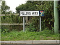
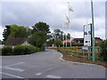
Millers Way sign
by
Geographer
for square
TM2763
On Millers Way at the junction with the B1119 Mount Pleasant
Tags:
B1119
X
B1119 Mount Pleasant
X
at:
Framlingham
X
on:
Millers Way
Millers Way
Mount Pleasant
X
Road Junction
X
Road Name Sign
X
top:
Roads, Road Transport
X
subject:
Sign
X
top:
Village, Rural Settlement
X
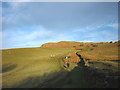
The route to the open fell above Bannisdale
by
Karl and Ali
geograph for square
NY5401
This bridleway soon enters open access land allowing free passage along the... (
more
)
Tags:
Fells
X
top:
Grassland
X
ldp:
Millers Way
top:
Paths
X
Public Bridleway
X
top:
Uplands
X
Walker
X
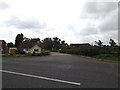
Millers Way, Framlingham
by
Geographer
geograph for square
TM2763
At the junction with the B1119 Mount Pleasant
Tags:
B1119
X
B1119 Mount Pleasant
X
at:
Framlingham
X
Millers Way
Mount Pleasant
X
subject:
Road Junction
X
Road Junction
X
top:
Roads, Road Transport
X
top:
Village, Rural Settlement
X
B1119 Mount Pleasant, Framlingham
by
Geographer
geograph for square
TM2763
At the junction with Millers Way
Tags:
B Road (Classified B)
X
B1119
X
B1119 Mount Pleasant
X
at:
Framlingham
X
Millers Way
Mount Pleasant
X
subject:
Road Junction
X
top:
Roads, Road Transport
X
top:
Village, Rural Settlement
X
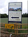
King's Mead New Homes advertisement sign at Millers Way
by
Geographer
for square
TM2763
Off the B1119 Mount Pleasant
Tags:
B1119
X
at:
Framlingham
X
Kings Mead
X
at:
Millers Way
Mount Pleasant
X
top:
Roads, Road Transport
X
subject:
Sign
X
off:
The B1119 Mount Pleasant
X
B1119 Mount Pleasant, Framlingham
by
Geographer
geograph for square
TM2763
Looking towards Saxtead at the junction to Millers Way
Tags:
B Road (Classified B)
X
B1119
X
B1119 Mount Pleasant
X
at:
Framlingham
X
Kings Mead
X
Millers Way
Mount Pleasant
X
subject:
Road
X
Road Junction
X
top:
Roads, Road Transport
X
looking towards:
Saxtead
X
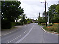
B1119 Mount Pleasant,Framlingham
by
Geographer
geograph for square
TM2763
Looking towards Framlingham at the junction with Millers Way
Tags:
B Road (Classified B)
X
B1119
X
B1119 Mount Pleasant
X
looking towards:
Framlingham
X
at:
Framlingham
X
Kings Mead
X
Millers Way
Mount Pleasant
X
subject:
Road
X
Road Junction
X
top:
Roads, Road Transport
X
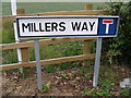
Millers Way sign
by
Geographer
for square
TM2763
At the junction with the B1119 Mount Pleasant
Tags:
B1119
X
B1119 Mount Pleasant
X
at:
Framlingham
X
Millers Way
Mount Pleasant
X
Road Junction
X
Road Name Sign
X
top:
Roads, Road Transport
X
subject:
Sign
X
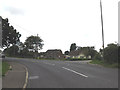
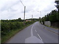
Millers Way, Framlingham
by
Geographer
geograph for square
TM2763
At the junction with the B1119 Mount Pleasant
Tags:
B Road (Classified B)
X
B1119
X
B1119 Mount Pleasant
X
at:
Framlingham
X
Millers Way
Mount Pleasant
X
subject:
Road Junction
X
top:
Roads, Road Transport
X
Village Street
X
View more in the Image Search
or
in Browser
View images matching 'Millers Way' anywhere
in
the tags
Don't click these:
PotMel 1
PotMel 2
☰
Home
View
Search
Marked Images
Maps
Browser
Explore
Showcase
New Images
Collections
Interact
Games
Discussions
Blog
Contributors
Submit
Statistics
Leaderboards
General
FAQ
Help Pages
Sitemap
Contact Us
Support Us
sponsored by
🔍
What to search:
Photos
Enter keywords or a location/postcode to search nearby images
Enter a Grid Reference
Placenames
Collections
Website Pages
Everything
Others:
Advanced Search
|
Image Browser
Or:
Coverage Map
|
Searchable Map
You are not logged in
login
|
register