Public Tags
Tag: Monsall·Trail
Showing latest 50 of 143 images tagged with Monsall Trail tag.
|
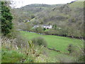
The Monsal Trail, Chee Dale
by Adrian Taylor geograph for square SK1273 The series of viaducts and tunnels required to carry the former Midland Railway... (more)
Tags:
AutumnX
place:Chee DaleX
Chee Tor No. 1X
Chee Tor No.2X
county:DerbyshireX
Disused Railway TrackbedX
Disused Railway TunnelX
type:GeographX
rock:LimestoneX
long distance footpath:Monsal TrailX
top:PathsX
top:RailwaysX
river:River WyeX
top:Rocks, Scree, CliffsX
subject:TrailX
river:Wye (Derbyshire)X
|
|
The Monsal Trail
by Richard Croft geograph for square SK1373 View east from the former Millers Dale Station
Tags:
Cycle PathX
Disused RailwayX
type:GeographX
place:Monsal TrailX
National Cycle Route 680X
top:PathsX
top:Sport, LeisureX
|
|
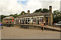
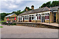
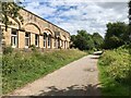
Former Millers Dale Station
by Richard Croft geograph for square SK1373 Former station buildings now providing refreshments and toilet facilities on the... (more)
Tags:
type:GeographX
place:Monsal TrailX
National Cycle Route 680X
former:Railway StationX
top:RailwaysX
top:Sport, LeisureX
|
|
Former Millers Dale Station
by Richard Croft geograph for square SK1373 Between the platforms on The Monsal Trail at the former Millers Dale Station
Tags:
Cycle PathX
Disused RailwayX
Former Station PlatformX
type:GeographX
place:Monsal TrailX
National Cycle Route 680X
top:PathsX
former:Railway StationX
|
|
Former Railway Station at Miller's Dale
by David Dixon geograph for square SK1373 Built by the Midland Railway in 1863, Miller's Dale station was at the... (more)
|
|
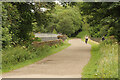
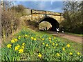
Daffodils beside the Monsal Trail
by Graham Hogg geograph for square SK2169 The bridge carries the A619 over the Trail. The runners passing under the bridge... (more)
|
|
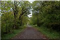
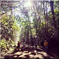
Autumn on the Monsal Trail
by Chris Heaton geograph for square SK1473 Section of the former railway track that once connected Manchester to Matlock,... (more)
Tags:
CyclewayX
Disused RailwayX
Former RailwayX
type:GeographX
Leisure TrailX
long distance footpath:Monsal TrailX
top:PathsX
|
|
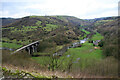
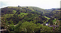
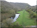
The view from Monsal Head
by Chris Allen geograph for square SK1871 Looking towards Cressbrook with the River Wye in the valley bottom and the... (more)
Tags:
place:DerbyshireX
type:GeographX
place:Monsal DaleX
place:Monsal TrailX
top:RailwaysX
top:Rivers, Streams, DrainageX
top:UplandsX
ViaductX
subject:ViewX
river:Wye (Derbyshire)X
|
|
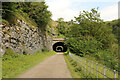
Monsal Trail
by Richard Croft geograph for square SK1273 Approaching Chee Tor 2 Tunnel on the Monsal Trail
|
|
Monsal Trail, Hassop Station
by David Dixon geograph for square SK2170 Hassop railway station was situated about two miles from the village of Hassop.... (more)
Tags:
top:Business, Retail, ServicesX
CafeX
type:GeographX
camera:IPhone 7X
Long Distance PathX
Monsal TrailX
top:PathsX
Peak DistrictX
Route of Former RailwayX
|

|
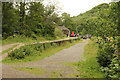
Runners on the Monsal Trail
by Graham Hogg geograph for square SK2070 Some of the over 150 runners taking part in the Bakewell parkrun along the... (more)
Tags:
Former Railway Track BedX
type:GeographX
place:Great LongstoneX
Monsal TrailX
ParkrunX
top:PathsX
top:RailwaysX
subject:SportX
top:Sport, LeisureX
|
|
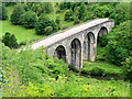
Monsal Dale Viaduct
by David Dixon geograph for square SK1871 Constructed in 1862-3 to carry the former Midland Railway line which was closed... (more)
|
|
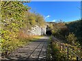
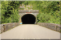
Chee Tor Tunnel
by Richard Croft geograph for square SK1273 View from the short viaduct over the River Wye towards Chee Tor Tunnel on the Monsal Trail
|
|
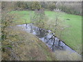
River Wye from the Monsal Trail
by Marathon geograph for square SK1771 The line which now forms part of the Monsal Trail was built by the Midland... (more)
Tags:
top:Derelict, DisusedX
Former RailwayX
type:GeographX
Monsal TrailX
top:PathsX
top:RailwaysX
top:Rivers, Streams, DrainageX
|
|
On the Monsal Trail
by Marathon geograph for square SK1771 The line which now forms part of the Monsal Trail was built by the Midland... (more)
|

|
On the Monsal Trail
by Chris Heaton geograph for square SK1473 Section of the former Manchester/Matlock railway that closed in 1968. Now a very... (more)
Tags:
CyclewayX
Disused RailwayX
Former RailwayX
type:GeographX
Leisure TrailX
long distance footpath:Monsal TrailX
top:PathsX
TreesX
|

|
Cutting on the Monsal Trail
by Chris Heaton geograph for square SK1473 Section of the former Manchester to Matlock line, built by the Midland Railway... (more)
Tags:
CuttingX
CyclewayX
Disused RailwayX
Former RailwayX
type:GeographX
Leisure TrailX
long distance footpath:Monsal TrailX
top:PathsX
|
|
Twin Viaducts at Millers Dale
by Chris Heaton for square SK1373 These viaducts span the River Wye at Millers Dale. The first viaduct was built... (more)
Tags:
type:Cross GridX
CyclewayX
Disused RailwayX
Leisure TrailX
long distance footpath:Monsal TrailX
top:PathsX
ViaductsX
|

|
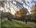
Autumn colour on the Monsal Trail
by Graham Hogg geograph for square SK2071 The runners are taking part in the 42nd running of Bakewell parkrun
Tags:
Autumn ColourX
type:GeographX
place:Great LongstoneX
Monsal TrailX
ParkrunX
top:PathsX
top:People, EventsX
top:RailwaysX
subject:TrailX
|
|
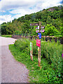
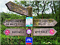
Signpost on the Monsal Trail
by David Dixon geograph for square SK1373 Tags:
type:GeographX
Long Distance RouteX
Monsal TrailX
camera:Panasonic DMC-G7X
top:PathsX
Peak DistrictX
SignpostX
|
|
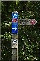
Refreshments This Way!
by David Dixon for square SK1373 A closer look at one of the signposts on the Monsal Trail.
Tags:
type:Close LookX
bucket:CloseupX
DetailX
Long Distance RouteX
Monsal TrailX
camera:Panasonic DMC-G7X
top:PathsX
Peak DistrictX
SignpostX
|
|
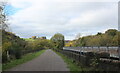
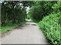
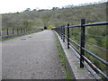
The Monsal Trail at Miller's Dale
by David Dixon geograph for square SK1473 Tags:
Former Railway Track BedX
type:GeographX
camera:IPhone 7X
Long Distance RouteX
Monsal TrailX
top:PathsX
Peak DistrictX
|
|
Monsal Trail near Miller's Dale
by David Dixon geograph for square SK1473 Tags:
Former Railway Track BedX
type:GeographX
camera:IPhone 7X
Long Distance RouteX
Monsal TrailX
top:PathsX
Peak DistrictX
top:RailwaysX
|
|
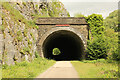
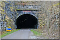
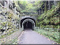
Chee Tor Tunnel No.2
by Richard Croft geograph for square SK1273 Western portal of Chee Tor Tunnel No.2 on the Monsal Trail
|
|
Rusher Cutting Tunnel
by Richard Croft for square SK1272 The Monsal Trail inside Rusher Cutting Tunnel
Tags:
Cycle PathX
Disused RailwayX
Former Railway TunnelX
type:InsideX
place:Monsal TrailX
National Cycle Route 680X
top:PathsX
top:RailwaysX
|
|
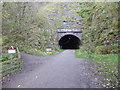
Rusher Cutting Tunnel portal
by Richard Croft for square SK1272 West tunnel portal on The Monsal Trail
Tags:
type:Cross GridX
Cycle PathX
Disused RailwayX
place:Monsal TrailX
National Cycle Route 680X
top:PathsX
Railway Tunnel PortalX
top:RailwaysX
Tunnel PortalX
|
|
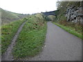
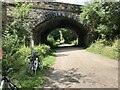
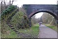
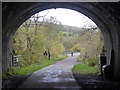
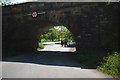
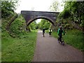
Bridge across the Monsal Trail at Hassop
by David Dixon geograph for square SK2170 Tags:
BridgeX
type:GeographX
camera:IPhone 7X
Long Distance PathX
Monsal TrailX
top:PathsX
Peak DistrictX
Route of Former RailwayX
|
|
Morning sunlight at Bakewell parkrun
by Graham Hogg geograph for square SK1971 Bakewell parkrun is an out & back course on the Monsal Trail between Hassop... (more)
|
|
Bakewell parkrun briefing
by Graham Hogg geograph for square SK2170 The run director giving the briefing to runners/joggers/walkers assembled at... (more)
|
|
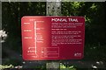
Route description
by Bob Harvey for square SK2071 Description of the Monsal Trail on SK2071 : Fingerpost on the path
|
|
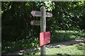
Fingerpost on the path
by Bob Harvey for square SK2071 Directions for users of the Monsal Trail
|

|
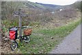
Cycling on the Monsal Trail
by Bob Harvey geograph for square SK2071 |
|
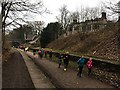
Running through the former Great Longstone railway station
by Graham Hogg geograph for square SK1971 Some of the 151 runners taking part in the Bakewell parkrun along the Monsal... (more)
Tags:
type:GeographX
place:Great LongstoneX
Monsal TrailX
ParkrunX
top:PathsX
former:Railway StationX
top:RailwaysX
subject:SportX
top:Sport, LeisureX
top:Village, Rural SettlementX
|

|
The former Monsal Dale station
by Marathon geograph for square SK1771 The line which now forms part of the Monsal Trail was built by the Midland... (more)
|
|
Crossing Monsal Viaduct
by Marathon geograph for square SK1871 Monsal Viaduct is 300 feet long and has five 50 feet spans. The viaduct was... (more)
Tags:
top:Derelict, DisusedX
Former Railway ViaductX
type:GeographX
Monsal TrailX
top:PathsX
top:RailwaysX
|
|
Monsal Dale from Monsal Head, 2004
by Ben Brooksbank geograph for square SK1871 No apologies for offering yet another photograph of the incomparable view NW... (more)
Tags:
type:GeographX
Midland Peak LineX
place:Monsal DaleX
Monsal HeadX
Monsal TrailX
top:MoorlandX
top:PathsX
top:RailwaysX
top:Rivers, Streams, DrainageX
top:UplandsX
|
|
Finger post on the Monsal Trail
by David Lally geograph for square SK1573 A longer view of SK1573 : Finger post on the Monsal Trail, with bike.
|
|
Bridge over the Monsal Trail
by David Lally geograph for square SK1572 Carries a footpath from Litton Mill.
|
|
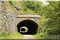
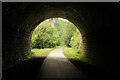
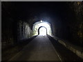
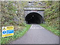
Looking to the western entrance to Headstone Tunnel
by Marathon geograph for square SK1871 Headstone Tunnel on the Monsal Trail in the Peak District is nearly one third of... (more)
Tags:
top:Derelict, DisusedX
Former Railway TunnelX
type:GeographX
Monsal TrailX
top:PathsX
top:RailwaysX
|
|
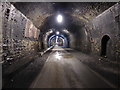
Inside Headstone Tunnel
by Marathon for square SK1871 Headstone Tunnel on the Monsal Trail in the Peak District is nearly one third of... (more)
Tags:
top:Derelict, DisusedX
Former Railway TunnelX
type:InsideX
Monsal TrailX
top:PathsX
top:RailwaysX
|
|
Monsal Trail - Cressbrook Tunnel
by Chris Allen for square SK1772 Part of the cycling trail along Monsal Dale where it enters a tunnel that is lit... (more)
Tags:
type:Close LookX
place:CressbrookX
place:Monsal DaleX
place:Monsal TrailX
top:PathsX
former:Railway TunnelX
top:RailwaysX
subject:TunnelX
|
|
Fingerpost
by Bob Harvey for square SK2071 |
|
Through the bridge
by Bob Harvey geograph for square SK2071 Tags:
subject:BridgeX
Former Railway BridgeX
type:GeographX
Monsal TrailX
top:Roads, Road TransportX
top:UplandsX
|
|
River Wye from Monsal Viaduct
by Marathon geograph for square SK1871 The line which now forms part of the Monsal Trail was built by the Midland... (more)
|
|
River Wye from Monsal Viaduct
by Marathon geograph for square SK1871 The line which now forms part of the Monsal Trail was built by the Midland... (more)
|
|
Looking to the eastern entrance to Headstone Tunnel
by Marathon for square SK1871 Headstone Tunnel on the Monsal Trail in the Peak District is nearly one third of... (more)
Tags:
top:Derelict, DisusedX
Former Railway TunnelX
type:InsideX
Monsal TrailX
top:PathsX
top:RailwaysX
|
|
The eastern entrance to Headstone Tunnel
by Marathon geograph for square SK1871 Headstone Tunnel on the Monsal Trail in the Peak District is nearly one third of... (more)
Tags:
top:Derelict, DisusedX
Former Railway TunnelX
type:GeographX
Monsal TrailX
top:PathsX
top:RailwaysX
|
|
The entrance to Headstone Tunnel
by Marathon geograph for square SK1871 Headstone Tunnel on the Monsal Trail in the Peak District is nearly one third of... (more)
Tags:
top:Derelict, DisusedX
Former Railway TunnelX
type:GeographX
Monsal TrailX
top:PathsX
top:RailwaysX
|
|
Entrance to Headstone Tunnel
by Marathon geograph for square SK1871 Headstone Tunnel on the Monsal Trail in the Peak District is nearly one third of... (more)
Tags:
top:Derelict, DisusedX
Former Railway TunnelX
type:GeographX
Monsal TrailX
top:PathsX
top:RailwaysX
|
|
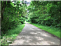
On the Monsal Trail
by Graham Hogg geograph for square SK1572 The Monsal Trail is an 8.5 mile cycle, horse riding and walking trail between... (more)
Tags:
Former Railway Track BedX
Monsal TrailX
top:PathsX
Peak DistrictX
top:RailwaysX
top:Sport, LeisureX
|