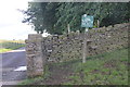
Public Tags
Tag: North·Cheshire·Way
Other tags: long distance path:North Cheshire Way
Showing images tagged with North Cheshire Way tag.
|
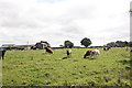
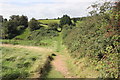
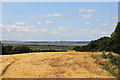
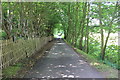
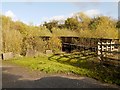
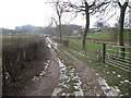
The North Cheshire Way at Hatley Farm
by Jeff Buck geograph for square SJ5376 Heading south along the North Cheshire Way as it passes across Hatley Farm.
Tags:
place:BradleyX
county:CheshireX
country:EnglandX
FarmX
top:Farm, Fishery, Market GardeningX
FieldX
type:GeographX
Long Distance PathX
long distance path:North Cheshire Way
North Cheshire Way
top:PathsX
|
|
The North Cheshire Way
by Jeff Buck geograph for square SJ5376 The North Cheshire Way heading north across a field at Hatley Farm.
Tags:
place:BradleyX
county:CheshireX
country:EnglandX
FarmX
top:Farm, Fishery, Market GardeningX
FieldX
type:GeographX
Long Distance PathX
long distance path:North Cheshire Way
North Cheshire Way
top:PathsX
|
|
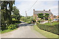
The North Cheshire Way passing Brook Farm
by Jeff Buck geograph for square SJ5376 The North Cheshire Way passing Brook Farm along Watery Lane south of Bradley.
Tags:
place:BradleyX
county:CheshireX
country:EnglandX
FarmX
top:Farm, Fishery, Market GardeningX
type:GeographX
LaneX
Long Distance PathX
long distance path:North Cheshire Way
North Cheshire Way
top:PathsX
|
|
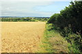
The North Cheshire Way at Five Crosses Farm
by Jeff Buck geograph for square SJ5276 The North Cheshire Way heading north east at Five Crosses Farm.
Tags:
county:CheshireX
country:EnglandX
top:Farm, Fishery, Market GardeningX
place:FrodshamX
type:GeographX
Long Distance PathX
North Cheshire Way
long distance path:North Cheshire Way
top:PathsX
|
|
The North Cheshire Way near Frodsham
by Jeff Buck geograph for square SJ5276 The North Cheshire Way heading north west towards Manley Road near Frodsham.... (more)
Tags:
county:CheshireX
country:EnglandX
top:Farm, Fishery, Market GardeningX
place:FrodshamX
type:GeographX
Long Distance PathX
long distance path:North Cheshire Way
North Cheshire Way
top:PathsX
|
|
The North Cheshire Way at Fivecrosses
by Jeff Buck geograph for square SJ5276 The North Cheshire Way passing along Top Road in Fivecrosses near Frodsham.
Tags:
country:EnglandX
place:FivecrossesX
place:FrodshamX
type:GeographX
Long Distance PathX
long distance path:North Cheshire Way
North Cheshire Way
top:PathsX
top:Roads, Road TransportX
top:UplandsX
top:Village, Rural SettlementX
|
|
The North Cheshire Way near Woodhouses
by Jeff Buck geograph for square SJ5076 The North Cheshire Way, here seen heading north-east near Woodhouse Hill is one... (more)
|
|
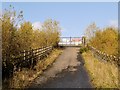
North Cheshire Way, Approaching Manchester Airport
by David Dixon geograph for square SJ8182 The path ahead is blocked by the Emergency Access Gate (SJ8182 : Manchester Airport Crash Gate Number 6); the... (more)
|
|
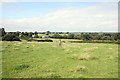
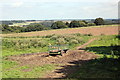
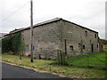
Hatley Farm
by Jeff Buck geograph for square SJ5376 View north east across the farm from the North Cheshire Way.
Tags:
place:BradleyX
county:CheshireX
country:EnglandX
FarmX
top:Farm, Fishery, Market GardeningX
FieldX
type:GeographX
Long Distance PathX
long distance path:North Cheshire Way
North Cheshire Way
top:PathsX
|
|
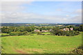
View across Fivecrosses
by Jeff Buck geograph for square SJ5276 The view north east across Fivecrosses from the North Cheshire Way.
Tags:
county:CheshireX
country:EnglandX
place:FrodshamX
type:GeographX
HillX
Long Distance PathX
North Cheshire Way
long distance path:North Cheshire Way
top:PathsX
top:Village, Rural SettlementX
|
|
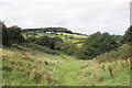
View towards Beacon Hill
by Jeff Buck geograph for square SJ5276 The view north west towards Beacon Hill near Frodsham from the North Cheshire Way.
|
|
The North Cheshire Way below Woodhouse Hill
by Jeff Buck geograph for square SJ5075 The North Cheshire Way, here seen heading south-west below Woodhouse Hill is one... (more)
|
|
View towards Liverpool from the North Cheshire Way
by Jeff Buck geograph for square SJ5176 The view north towards Liverpool from the North Cheshire Way near Dunsdale Hollow.
|
|
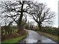
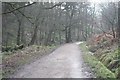
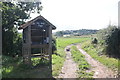
The North Cheshire Way near Helsby
by Jeff Buck geograph for square SJ5074 The North Cheshire Way is one of Cheshire's newest and longest paths. It... (more)
Tags:
place:AlvanleyX
county:CheshireX
country:EnglandX
place:HelsbyX
Long DistanceFootpathX
North Cheshire Way
top:PathsX
top:Village, Rural SettlementX
|

|
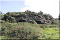
Sandstone Cave near Fivecrosses
by Jeff Buck geograph for square SJ5276 A sandstone outcrop with some caves next to the North Cheshire Way near Frodsham.
Tags:
county:CheshireX
country:EnglandX
place:FrodshamX
type:GeographX
top:Geological InterestX
long distance path:North Cheshire Way
North Cheshire Way
top:PathsX
Sandstone CaveX
top:UplandsX
|
|
Sandstone Caves near Fivecrosses
by Jeff Buck geograph for square SJ5276 A sandstone outcrop near the North Cheshire Way on the outskirts of Frodsham.
Tags:
county:CheshireX
country:EnglandX
place:FrodshamX
type:GeographX
top:Geological InterestX
long distance path:North Cheshire Way
North Cheshire Way
top:PathsX
Sandstone CavesX
Sandstone OutcropX
|
|
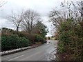
The North Cheshire Way near Helsby
by Jeff Buck geograph for square SJ4873 The North Cheshire Way south of Helsby as it runs along Peck Mill Lane.
Tags:
county:CheshireX
country:EnglandX
place:HelsbyX
Long Distance FootpathX
North Cheshire Way
top:Roads, Road TransportX
|
|
The North Cheshire Way near Woodhouse Hill
by Jeff Buck geograph for square SJ5075 The North Cheshire Way heading west away from Woodhouse Hill towards Helsby and... (more)
|
|
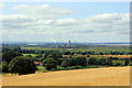
View towards Stanlow Refinery from the North Cheshire Way
by Jeff Buck geograph for square SJ5176 The view west towards Stanlow oil refinery from the North Cheshire Way near... (more)
|
|
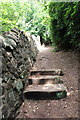
Remains of sandstone steps, North Cheshire Way
by Jeff Buck geograph for square SJ5176 Very little remains of these old sandstone steps on the North Cheshire Way near... (more)
|
|
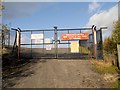
Manchester Airport Crash Gate Number 6
by David Dixon geograph for square SJ8182 The North Cheshire Way public footpath... (more)
|
|
Farm buildings at Greengate Farm
by Jeff Buck geograph for square SJ4973 Seen from the North Cheshire Way (Towers Lane).
Tags:
place:AlvanleyX
county:CheshireX
country:EnglandX
Farm BuildingsX
top:Farm, Fishery, Market GardeningX
North Cheshire Way
|
|
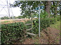
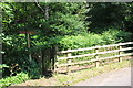
Stile and footpath near Alvanley
by Jeff Buck geograph for square SJ4973 Stile and footpath off the North Cheshire Way (Towers Lane) near Alvanley.
|
|
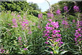
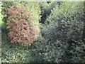
Rosebay Willowherb
by Jeff Buck for square SJ5176 There's lots of this wild flower next to the North Cheshire Way near Dunsdale Hollow.
Tags:
county:CheshireX
country:EnglandX
FootpathX
place:FrodshamX
North Cheshire Way
top:PathsX
plant:Rosebay WillowherbX
Rosebay WillowherbX
top:Wild Animals, Plants and MushroomsX
Wild FlowersX
|
|
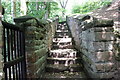
Sandstone Steps near Dunsdale Hollow
by Jeff Buck geograph for square SJ5176 These old, worn sandstone steps are on the North Cheshire Way. They appear to... (more)
|
|
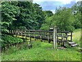
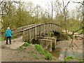
Footbridge over the River Bollin
by Graham Hogg geograph for square SJ8979 The bridge carries the North Cheshire Way. The footpath to the left is the... (more)
Tags:
place:AdlingtonX
subject:BridgeX
type:GeographX
North Cheshire Way
top:PathsX
River BollinX
top:Rivers, Streams, DrainageX
|
|
Heath Lane, looking north from a 36 metre spot height
by Christine Johnstone geograph for square SJ3477 Part of the North Cheshire Way and National Cycle Route 56.
Tags:
lane:Heath LaneX
subject:LaneX
National Cycle Route 56X
North Cheshire Way
top:Roads, Road TransportX
Rural LaneX
|
|
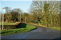
Ledhsam Lane, looking north
by Christine Johnstone geograph for square SJ3574 Part of the North Cheshire Way and national cycle route 56.
Tags:
subject:LaneX
National Cycle Route 56X
North Cheshire Way
top:Roads, Road TransportX
Rural LaneX
|
|
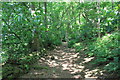
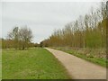
Path to Marbury Lane
by Stephen Craven geograph for square SJ6575 Part of the North Cheshire way, running through Anderton Nature Park.
|
|
Footbridge across Marbury Brook
by Stephen Craven geograph for square SJ6575 The location is shown on largest scale mapping as 'Lesley's... (more)
Tags:
BrookX
FootbridgeX
type:GeographX
North Cheshire Way
top:PathsX
top:Rivers, Streams, DrainageX
|
|
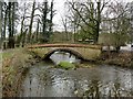
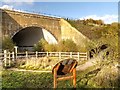
Bridge over the River Bollin
by Graham Hogg geograph for square SJ8382 The footbridge carries the North Cheshire Way over the river
Tags:
subject:BridgeX
type:GeographX
North Cheshire Way
top:Park and Public GardensX
top:PathsX
River BollinX
top:Rivers, Streams, DrainageX
place:WilmslowX
|
|
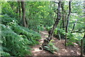
Entrance to Woodhouse Hill
by Jeff Buck geograph for square SJ5075 The North Cheshire Way continues from here through the woods below Woodhouse... (more)
Tags:
FootpathX
place:FrodshamX
place:HelsbyX
Long DistanceFootpathX
North Cheshire Way
subject:PathX
top:PathsX
top:Woodland, ForestX
|
|
Public bridleway to Oaks Farm, in winter
by Christine Johnstone geograph for square SJ3477 Part of the North Cheshire Way and national cycle route 56. For a similar view... (more)
Tags:
subject:BridlewayX
Light Snow CoverX
National Cycle Route 56X
North Cheshire Way
top:PathsX
Public BridlewayX
|
|
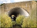
North Cheshire Way, Footbridge over River Bollin
by David Dixon geograph for square SJ8082 |
|
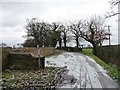
Path from West Parkgate
by Dave Dunford geograph for square SJ9581 Followed by the North Cheshire Way.
|
|
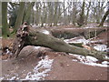
Derelict quarry Danielhill Wood,Mottram-St-Andrew
by Peter Turner geograph for square SJ8777 A wind-felled tree temporarily diverts the path of the North Cheshire Way around... (more)
|
|
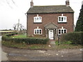
Turner House Farm, Mottram-St-Andrew
by Peter Turner geograph for square SJ8777 Looks like the house of traditional yeoman farmer probably at least 200 years... (more)
|
|
Shaws Lane, Mottram-St-Andrew
by Peter Turner geograph for square SJ8877 North Cheshire Way walkers negotiate these normally soggy stretches but a good... (more)
|
|
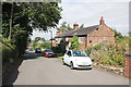
Free Range Eggs on Watery Lane
by Jeff Buck geograph for square SJ5376 Free range eggs with an honesty box on Watery Lane near Bradley.
|
|
The Dismantled Helsby to Mouldsworth Railway
by Jeff Buck geograph for square SJ4873 The overgrown dismantled Helsby to Mouldsworth Railway looking south from the... (more)
|
|
Track leading to Hollowood Farm
by Ian S geograph for square SJ7179 Tags:
top:Farm, Fishery, Market GardeningX
type:GeographX
long distance path:North Cheshire Way
Public Right of WayX
top:Roads, Road TransportX
|
|
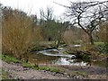
The River Bollin
by Graham Hogg geograph for square SJ8481 Flowing through The Carrs Park
Tags:
type:GeographX
North Cheshire Way
top:Park and Public GardensX
top:PathsX
subject:RiverX
River BollinX
top:Rivers, Streams, DrainageX
place:WilmslowX
|
|
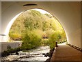
Looking Out
by David Dixon geograph for square SJ8082 The footbridge over the River Bollin, viewed from inside the Manchester Airport... (more)
|
|
River Bollin Runway Tunnel, Manchester Airport
by David Dixon geograph for square SJ8082 |
|
River Bollin, Manchester Airport
by David Dixon geograph for square SJ8082 Tunnel allowing the River Bollin to continue under the runway.
|
|
Footpath junction at Crow Wood
by Peter Turner geograph for square SJ9583 Accessing paths to Green Farm/Poynton/Platt Wood/Inglewood and Lyme Park... (more)
|