|
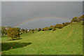
Rainbow at Priestcliffe, Derbyshire
by Andrew Tryon
geograph for square SK1471
A rainbow over the small Peak District hamlet of Priestcliffe, on a wet autumn day.
|
|
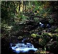
Waterfalls in Padley Gorge
by Andy Stephenson
geograph for square SK2579
A fine Peak District autumn view.
|

|
Tramper at Parsley Hay Cycle Hire, High Peak Trail, Peak District
by Phil Champion
for square SK1463
An off road capable mobility scooter, available for hire. There are also a... (more)
|
|
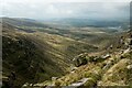
High Peak View
by Jeff Buck
geograph for square SK0888
View across the Peak District from the Pennine Way near Kinder Downfall.
|
|
On the Edge
by Andy Stephenson
geograph for square SK2575
Curbar Edge, looking north on a fine Autumn evening. Someone is perched on a... (more)
|
|
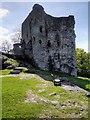
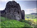
The Keep, Peveril Castle
by David Dixon
geograph for square SK1482
Built in 1174, on the orders of King Henry, the keep dominated the main entrance... (more)
|
|
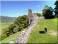
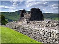
South-east Wall, Peveril Castle
by David Dixon
geograph for square SK1482
|
|
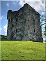
The Norman Keep, Peveril castle
by David Dixon
geograph for square SK1482
Built in 1174, on the orders of King Henry, the keep dominated the main entrance... (more)
|
|
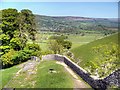
Peveril Castle, Castle Hill
by David Dixon
geograph for square SK1482
|
|
Peveril Castle, Curtain Wall
by David Dixon
geograph for square SK1482
|
|
Peveril Castle, Castleton
by David Dixon
geograph for square SK1482
|
|
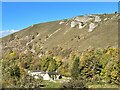
Netherdale Farm
by Adrian Taylor
geograph for square SK1871
A nineteenth century farm beside the River Wye in Monsal Dale, Netherdale Farm... (more)
|
|
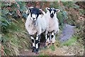
Derbyshire Gritstone Sheep
by Jeff Buck
for square SK1286
I met this couple near Grinds Brook north of Edale. The Derbyshire Gritstone... (more)
|
|
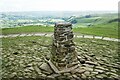
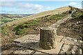
Mam Tor Trig Point
by Jeff Buck
geograph for square SK1283
The trig point on Mam Tor, a 517 m (1,696 ft) hill near Castleton in... (more)
|
|
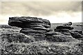
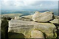
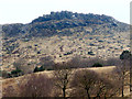
Gritstone in the Peak District
by Jeff Buck
geograph for square SK0789
Strange and fascinating gritstone rock formations next to the Pennine Way near... (more)
|
|
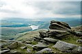
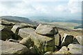
View from Sandy Heys
by Jeff Buck
geograph for square SK0789
View towards Kinder Reservoir from the top of Sandy Heys in the Peak District.
|
|
Kinder Downfall
by Jeff Buck
geograph for square SK0888
The tallest waterfall in the Peak District was not so much a downfall as a... (more)
|
|
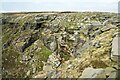
Gritstone Boulders in the Peak District
by Jeff Buck
geograph for square SK0787
Gritstone boulders next to the Pennine Way near Kinder Scout.
|
|
Gritstone Rocks and the Peak District
by Jeff Buck
geograph for square SK0787
Gritstone boulders next to the Pennine Way near Kinder Scout.
|
|
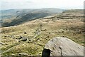
View from Edale Rocks towards the Pennine Way
by Jeff Buck
geograph for square SK0786
Looking south from Edale Rocks down towards the Pennine Way in the Peak District.
|
|
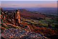
Autumn evening on Curbar Edge
by Andy Stephenson
geograph for square SK2575
Baslow Edge in the background. The classic rock of the area, Millstone Grit, is... (more)
|
|
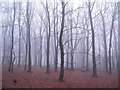
Misty Woodland in the Peak District
by Andrew Tryon
geograph for square SK2378
Sheriff Woods near Hathersage and Grindleford in the Hope Valley
|
|
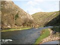
Dovedale
by Adrian Taylor
geograph for square SK1451
The River Dove in Dovedale between Bunster Hill and Thorpe Cloud. Near to the... (more)
|
|
Memorial at Hollins Cross
by Jeff Buck
geograph for square SK1384
The memorial to Tom Hyett was erected by the Long Eaton and District Group of... (more)
|
|
Stoney Middleton
by Dave Pickersgill
geograph for square SK2275
|
|
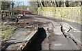
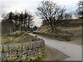
The road to Eyam
by Dave Pickersgill
geograph for square SK2276
The currently closed road to Eyam.
|
|
Stoke Hall Hotel and Froggatt
by Dave Pickersgill
for square SK2476
Stoke Hall Hotel with the village of Froggatt in the background.
|
|
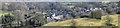
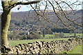
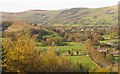
The Hope Valley
by Dave Pickersgill
for square SK1783
The village of Hope and the Hope Valley in the Peak District.
|
|
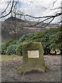
Matthew Whitson Memorial, Ashway Gap
by David Dixon
geograph for square SE0204
Memorial stone above Dove Stone Reservoir. The distinctive shape of... (more)
|
|
Winnatts Road, the top of Winnatts Pass
by David Dixon
geograph for square SK1282
Winnats Pass is in the High Peak area of the English county of Derbyshire. It... (more)
|
|
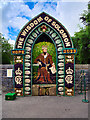
The Wisdom of Solomon - Hope Well Dressing 2023
by David Dixon
for square SK1783
Well dressing outside St Peter's Church.
Well dressing, also known as... (more)
|
|
Baslow, Calver Road
by David Dixon
geograph for square SK2572
Baslow is a village in the Peak District, lying between Sheffield and Bakewell.... (more)
|
|
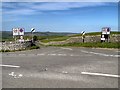
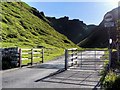
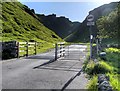
Cattle Grid at the bottom of Winnatts Pass
by David Dixon
geograph for square SK1382
Winnats Pass is in the High Peak area of the English county of Derbyshire. It... (more)
|
|
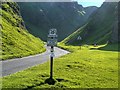
Winnats Pass
by David Dixon
geograph for square SK1382
Winnats Pass is in the High Peak area of the English county of Derbyshire. It... (more)
|
|
Arthurs Way, The road through Winnatts Pass
by David Dixon
geograph for square SK1382
Winnats Pass is in the High Peak area of the English county of Derbyshire. It... (more)
|
|
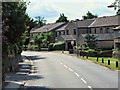
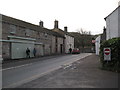
How Lane - Castleton, Derbyshire
by Martin Richard Phelan
geograph for square SK1583
A view of a corner of this Peak District village, popular year-round with... (more)
|
|
The Indian's Head
by David Dixon
for square SE0102
The jagged rocky skyline of Wimberry Stones, to the south of Dove Stone... (more)
|
|
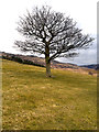
Tree above Dove Stone Reservoir
by David Dixon
geograph for square SE0103
|
|
Binn Green
by David Dixon
geograph for square SE0204
|
|
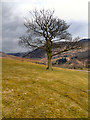
Tree above Dove Stone Reservoir
by David Dixon
geograph for square SE0103
|
|
View towards Wimberry Stones
by David Dixon
geograph for square SE0103
A view looking south from the path above the Dove Stone Reservoir.
|
|
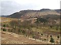
View towards Hoarstone Edge
by David Dixon
geograph for square SE0103
The view from the path around Dove Stone Reservoir. The path in the distance... (more)
|
|
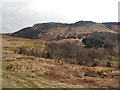
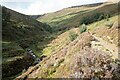
Stream above Grinds Brook
by Jeff Buck
geograph for square SK1187
A stream about to enter Grinds Brook in Grindsbrook Clough.
|
|
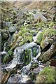
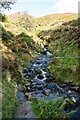
A waterfall on Grinds Brook
by Jeff Buck
geograph for square SK1187
A small waterfall on Grinds Brook as it flows along Grindsbrook Clough.
|
|
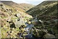
Grinds Brook along Grindsbrook Clough
by Jeff Buck
geograph for square SK1187
Looking southeast along Grinds Brook.
|
|
Below Grindsbrook Clough
by Jeff Buck
geograph for square SK1187
Heading northwest along a path above Grinds Brook below Grindsbrook Clough.
|
|
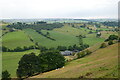
Crowdecote Ridge
by Phil Brandon Hunter
geograph for square SK1164
The B5055, Tagg Lane, seen looking west over Crowdecote Ridge shortly before... (more)
|
|
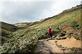
Above Grinds Brook
by Jeff Buck
geograph for square SK1186
Heading north alongside Grinds Brook north of Edale. Upper Tor can be seen in... (more)
|
|
Stream below Golden Clough
by Jeff Buck
geograph for square SK1286
This stream passes through Golden Clough, a steep sided valley which I think can... (more)
|
|
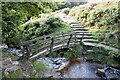
Footbridge below Golden Clough
by Jeff Buck
geograph for square SK1286
A footbridge over a stream below Golden Clough. The stream enters Grinds Brook nearby.
|