Public Tags
Tag: Pettycur·Bay
Showing images tagged with Pettycur Bay tag.
|
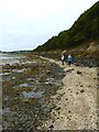
Shoreline footpath
by James Allan geograph for square NT2586 Near high water on Pettycur Bay between Kinghorn and Burntisland.
Tags:
top:CoastalX
Fife Coastal PathX
type:GeographX
subject:PathX
top:PathsX
Pettycur Bay
top:Woodland, ForestX
|
|
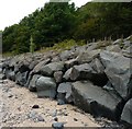
Coastal defences
by James Allan geograph for square NT2586 Boulders have been placed near high-water mark along Pettycur Bay to prevent... (more)
Tags:
subject:BoundaryX
top:CoastalX
Coastal DefencesX
type:GeographX
Pettycur Bay
top:RailwaysX
top:Rocks, Scree, CliffsX
|