Public Tags
Tag: Portway
Showing images tagged with Portway tag.
|
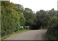
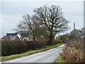
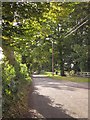
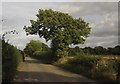
Bend onto the Portway
by Derek Harper geograph for square SU4149 The road from St Mary Bourne joins the line of the Portway, a Roman road, at... (more)
|
|
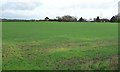
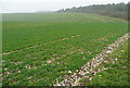
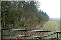
Farmland at Portway
by Christine Johnstone geograph for square SK2109 Looking north-east from a field gate on Portway Lane.
|
|
On the Portway
by Graham Horn geograph for square SU4953 This is The Portway, the line of a Roman road from Old Sarum to Silchester, now... (more)
|
|
View from Portway
by Graham Horn geograph for square SU4853 Would the Romans have had this view? Quite possibly. I am on The Portway, now... (more)
|
|
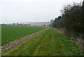
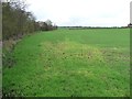
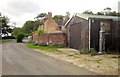
Roadside tree near Portway Farm
by Christine Johnstone geograph for square SK2109 Looking southwards along Portway Lane.
|
|
Towards Portway
by Graham Horn geograph for square SU4853 The tree belt running obliquely right to left is called Caesar's Belt. In... (more)
Tags:
BridlewayX
Caesars BeltX
CropX
top:Farm, Fishery, Market GardeningX
top:PathsX
Portway
WheatX
top:Woodland, ForestX
|
|
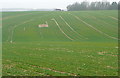
Discoloured crop at a field entrance, Portway
by Christine Johnstone geograph for square SK2109 Caused by pollution?
|
|
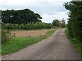
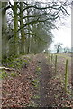
Track and public footpath to Portway Barn
by Christine Johnstone geograph for square SP0550 Running south from New Inn Lane.
|
|
Portway at Finkley
by Derek Harper geograph for square SU3848 Opposite the entrance to Finkley House, with the line of the Roman road (and... (more)
|
|
Portway at Finkley
by Derek Harper geograph for square SU3848 The Roman road (and NCN246) passes SU3848 : Finkley Manor Farm, with an old petrol pump against... (more)
|
|
Along the Portway
by Graham Horn geograph for square SU5054 This is the line of the Roman road from Silchester to Old Sarum; these days it... (more)
|
|
Along the Portway
by Graham Horn geograph for square SU4954 This is the line of the Roman road from Silchester to Old Sarum; these days it... (more)
|
|
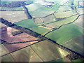
The Portway
by M J Richardson for square SU4953 Caesar's Belt marks the line of the Roman Road across the Hampshire landscape.
Tags:
type:AerialX
Aerial PhotographX
type:Cross GridX
top:Farm, Fishery, Market GardeningX
FieldsX
county:HampshireX
top:Historic Sites and ArtefactsX
subject:LandscapeX
top:LowlandsX
roman road:Portway
top:Roads, Road TransportX
top:Woodland, ForestX
WoodsX
|
|
The Portway
by M J Richardson for square SU5054 Robley Belt follows the line of the Roman Road west of Basingstoke.
Tags:
type:AerialX
Aerial PhotographX
near:BasingstokeX
type:Cross GridX
top:Farm, Fishery, Market GardeningX
county:HampshireX
top:LowlandsX
roman road:Portway
top:Roads, Road TransportX
subject:Roman RemainsX
top:Woodland, ForestX
WoodsX
|
|
Old Sarum, The Portway
by Mike Faherty geograph for square SU1533 Former Roman road from Old Sarum to Silchester. The area is now subject to... (more)
Tags:
top:Construction, DevelopmentX
type:GeographX
top:Historic Sites and ArtefactsX
top:LowlandsX
Portway
subject:RoadX
top:Roads, Road TransportX
Roman RoadX
top:Suburb, Urban FringeX
|
|
The Chariot Mine and the Chariot Way
by Ian Calderwood geograph for square SK2555 The Chariot Mine was a lead mine which operated between about 1700 and 1900. The... (more)
Tags:
Ancient TrackwayX
name:Chariot MineX
name:Chariot WayX
type:GeographX
former:Lead MineX
subject:MineX
top:PathsX
name:Portway
top:Quarrying, MiningX
top:Roads, Road TransportX
|
|
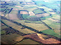
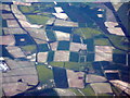
Field patterns, Hampshire
by M J Richardson for square SU5152 Looking west from near Basingstoke towards Andover. The narrow strip of wood at... (more)
Tags:
Aerial PhotographX
top:Farm, Fishery, Market GardeningX
FarmlandX
FieldsX
place:HampshireX
HarrowayX
top:Historic Sites and ArtefactsX
subject:LandscapeX
top:LowlandsX
roman road:Portway
near:QuidhamptonX
top:Roads, Road TransportX
top:Woodland, ForestX
|
|
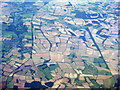
Hampshire fieldscape from the air
by M J Richardson for square SU5152 Looking west from 37000 feet above the Basingstoke area. The straight line on... (more)
Tags:
Aerial PhotographX
top:Farm, Fishery, Market GardeningX
subject:FarmlandX
FieldsX
HampshireX
top:LowlandsX
Portway
top:RailwaysX
top:Rivers, Streams, DrainageX
top:Roads, Road TransportX
Roman RoadX
Test ValleyX
|
|
Portway at Finkley
by Derek Harper geograph for square SU3848 With a wide verge. Ahead is the farmhouse seen in SU3848 : Finkley Manor Farm. The turning on the... (more)
|
|
Portway near Finkley
by Derek Harper geograph for square SU3948 Finkley Road (and NCN246) follows the line of the Roman road up a hill at Lesleys Cottage.
|
|
Portway near Trinley Lodge
by Derek Harper geograph for square SU3948 The line of the Roman road is used by Finkley Road and NCN246. An all too brief... (more)
|
|
Portway at Middle Wyke
by Derek Harper geograph for square SU4049 Finkley Road (and NCN246) follows the line of the Roman road through the hamlet.... (more)
|
|
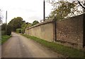
Wall, Middle Wyke Farm
by Derek Harper geograph for square SU4049 A wall with tile coping alongside the Portway (Finkley Road), outside the listed... (more)
|
|
M42 under junction 3 bridge
by J.Hannan-Briggs geograph for square SP0772 |
|
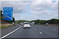
M42 approaching junction 3
by J.Hannan-Briggs geograph for square SP0872 Exit to the A435.
|