Geograph - photograph every grid square
About tags on Geograph
Tags
Geographical Context
Subjects
Types
Other Prefixes
Public Tags
Related Tags
|
Coverage Map
Tag:
Potters·Farm
Other tags:
near:
Potters Farm
to:
Potters Farm
Showing images tagged with
Potters Farm
tag.
View all tagged images
-
In Browser
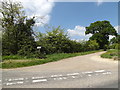
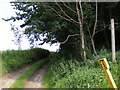
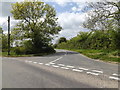
Entrance to Potter's Farm
by
Geographer
geograph for square
TM1653
Off Asbocking Road at the junction with Clay Lane
Tags:
off:
Asbocking Road
X
Clay Lane
X
subject:
Entrance
X
Farm Entrance
X
Farm Entrance Drive
X
Farm Entrance Lane
X
Farm Entrance Road
X
Farm Name Sign
X
top:
Farm, Fishery, Market Gardening
X
type:
Geograph
X
at:
Hemingstone
X
Potters Farm
to:
Potters Farm
at:
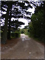
The Entrance to Potters Farm
X
top:
Village, Rural Settlement
X
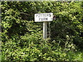
Potters Farm sign
by
Geographer
for square
TM1653
At the entrance to Potter's Farm off Asbocking Road at the junction with Clay Lane
Tags:
off:
Asbocking Road
X
Clay Lane
X
type:
Close Look
X
Farm Entrance
X
Farm Name Sign
X
top:
Farm, Fishery, Market Gardening
X
at:
Hemingstone
X
Potters Farm
subject:
Sign
X
at:
The Entrance to Potters Farm
X
top:
Village, Rural Settlement
X
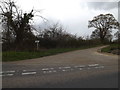
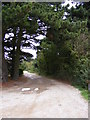
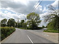
Entrance to Potter's Farm
by
Geographer
geograph for square
TM1653
Off Clay Lane at the junction with Ashbocking Road
Tags:
Ashbocking Road
X
off:
Clay Lane
X
subject:
Entrance
X
Farm Entrance
X
Farm Entrance Drive
X
Farm Entrance Lane
X
Farm Entrance Road
X
Farm Entrance Track
X
top:
Farm, Fishery, Market Gardening
X
at:
Hemingstone
X
Potters Farm
to:
Potters Farm
Road Junction
X
top:
Roads, Road Transport
X
top:
Village, Rural Settlement
X
Potter's Street
by
Geographer
geograph for square
TM4465
Looking towards the B1122 Leiston Road near the footpath to Potter's Farm... (
more
)
Tags:
B1122
X
near:
Eastbridge
X
Footpath
X
Leiston Road
X
Potters Farm
Potters Street
X
subject:
Road
X
top:
Roads, Road Transport
X
looking towards:
The B1122 Leiston Road
X
near:
Theberton
X
U Classified Road
X
U Road (Classified U)
X
Footpath to Potter's Farm & Baker's Hill
by
Geographer
geograph for square
TM4465
Off Potter's Street Theberton footpath no.10
Tags:
Bakers Hill
X
near:
Eastbridge
X
Footpath
X
subject:
Path
X
top:
Paths
X
Potters Farm
Potters Street
X
near:
Theberton
X
Sandlings Walk Bridleway to Upper Abbey & Potter's Farm
by
Geographer
geograph for square
TM4563
Sizewell Belt Trail Kenton Hills Walks Off Lover's Lane (U2822) Leiston... (
more
)
Tags:
subject:
Bridleway
X
Kenton Hills Walks
X
at:
Leiston
X
off:
Lovers Lane
X
top:
Paths
X
to:
Potters Farm
Potters Farm
Sandlings Walk
X
Sandlings Walk Bridleway
X
Sizewell Belt Trail
X
to:
Upper Abbey Farm
X
Sandlings Walk Bridleway to Upper Abbey & Potter's Farm
by
Geographer
geograph for square
TM4563
Sizewell Belt Trail Kenton Hills Walks Off Lover's Lane (U2822) Leiston... (
more
)
Tags:
subject:
Bridleway
X
Kenton Hills Walks
X
at:
Leiston
X
Lovers Lane
X
off:
Lovers Lane
X
top:
Paths
X
to:
Potters Farm
Potters Farm
Sandlings Walk
X
Sandlings Walk Bridleway
X
Sizewell Belt Trail
X
to:
Upper Abbey Farm
X
Sandlings Walk Bridleway to Upper Abbey & Potter's Farm
by
Geographer
geograph for square
TM4563
Sizewell Belt Trail Kenton Hills Walks Off Lover's Lane (U2822) Leiston... (
more
)
Tags:
Bridleway
X
subject:
Bridleway
X
Kenton Hills Walks
X
at:
Leiston
X
off:
Lovers Lane
X
Lovers Lane
X
top:
Paths
X
to:
Potters Farm
Potters Farm
Sandlings Walk
X
Sandlings Walk Bridleway
X
Sizewell Belt Trail
X
to:
Upper Abbey Farm
X
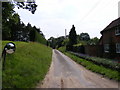
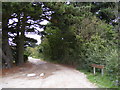
Clay Lane, Hemingstone
by
Geographer
geograph for square
TM1653
At the junction with Ashbocking Road near Potter's Farm
Tags:
Ashbocking Road
X
Clay Lane
X
type:
Geograph
X
at:
Hemingstone
X
Potters Farm
near:
Potters Farm
subject:
Road Junction
X
top:
Roads, Road Transport
X
top:
Village, Rural Settlement
X
Ashbocking Road, Hemingstone
by
Geographer
geograph for square
TM1653
At the junction with Clay Lane near Potter's Farm
Tags:
Ashbocking Road
X
Clay Lane
X
type:
Geograph
X
at:
Hemingstone
X
near:
Potters Farm
Potters Farm
subject:
Road Junction
X
top:
Roads, Road Transport
X
top:
Village, Rural Settlement
X
View more in the Image Search
or
in Browser
View images matching 'Potters Farm' anywhere
in
the tags
Don't click these:
PotMel 1
PotMel 2
☰
Home
View
Search
Marked Images
Maps
Browser
Explore
Showcase
New Images
Collections
Interact
Games
Discussions
Blog
Contributors
Submit
Statistics
Leaderboards
General
FAQ
Help Pages
Sitemap
Contact Us
Support Us
sponsored by
🔍
What to search:
Photos
Enter keywords or a location/postcode to search nearby images
Enter a Grid Reference
Placenames
Collections
Website Pages
Everything
Others:
Advanced Search
|
Image Browser
Or:
Coverage Map
|
Searchable Map
You are not logged in
login
|
register