Public Tags
Tag: Ramsey·Island
Other tags: island:Ramsey Island
place:Ramsey Island
Showing images tagged with Ramsey Island tag.
|
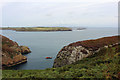
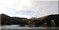
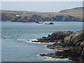
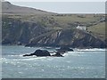
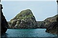
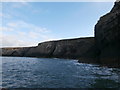
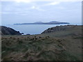
Ynys Berry seen from the coast of Ramsey Island
by John Dalling geograph for square SM7022 Looking out from the coast of Ramsey Island, off Pembrokeshire, Ynys Berry can be seen.
Tags:
top:Air, Sky, WeatherX
CliffsX
subject:CoastX
top:CoastalX
type:GeographX
subject:IslandX
top:IslandsX
county:PembrokeshireX
island:Ramsey Island
place:Ramsey Island
subject:RockX
RocksX
top:Rocks, Scree, CliffsX
country:WalesX
island:Ynys BerryX
|

|
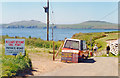
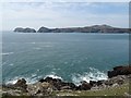
Ramsey Island
by Colin Smith for square SM7022 Distant view, over Ramsey Sound and The Bitches rocks, towards the rugged... (more)
|
|
|
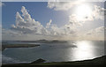
Ramsey Sound
by Colin Smith for square SM7022 View from St Justinian towards the southern exit from Ramsey Sound. On the left... (more)
Tags:
subject:ChannelX
top:CoastalX
type:Cross GridX
HeadlandX
top:IslandsX
place:Ramsey Island
Ramsey SoundX
|
|
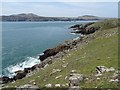
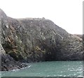
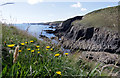
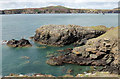
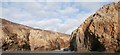
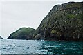
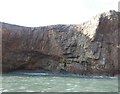
The rocky southern coast of Ramsey Island
by John Dalling for square SM7022 Cliffs on the southern edge of Ramsey Island, off the coast of Pembrokeshire.
Tags:
top:Air, Sky, WeatherX
subject:CliffX
CliffsX
subject:CoastX
top:CoastalX
type:Cross GridX
county:PembrokeshireX
Ramsey Island
place:Ramsey Island
RocksX
top:Rocks, Scree, CliffsX
SeaX
country:WalesX
|
|
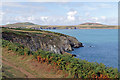
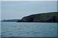
View to Ramsey Island
by Philip Halling geograph for square SM7123 View across Ramsey Sound to Ramsey Island from the coast path above Porthaflod.
|
|
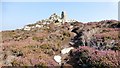
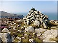
Foel Fawr
by Rude Health geograph for square SM7022 Foel Fawr and my 34th multi TUMP island completion on Ramsey Island.
Name:... (more)
|
|
The farmhouse, Ramsey Island
by HelenK geograph for square SM7023 There is some farmland on Ramsey Island, although the occupants of the farmhouse... (more)
Tags:
Cadw-Registered BuildingX
top:Docks, HarboursX
top:Farm, Fishery, Market GardeningX
FarmhouseX
type:GeographX
top:Housing, DwellingsX
top:IslandsX
place:Ramsey Island
top:Rocks, Scree, CliffsX
RSPBX
place:St DavidsX
|
|
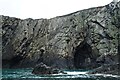
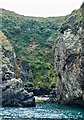
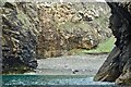
Caves on Ramsey Island
by HelenK geograph for square SM7024 Some of the many caves at the base of the cliffs around Ramsey Island. There... (more)
|
|
Ramsey Island
by Alan Hughes for square SM7024 The twin peaks of Ramsey Island from Carn ar Wig
Tags:
Carn Ar WigX
top:CoastalX
top:Estuary, MarineX
subject:IslandX
top:IslandsX
path:Pembrokeshire CoastX
Ramsey Island
|
|
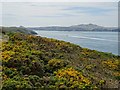
Ramsey Island
by Alan Hughes for square SM7024 Ramsey Island viewed from Carn Llidi across Whitesands Bay.
Tags:
top:Air, Sky, WeatherX
Carn LlidiX
top:CoastalX
top:Estuary, MarineX
subject:IslandX
top:IslandsX
place:Ramsey Island
Whitesands BayX
|
|
View over the Bitches to Ramsey Island
by Philip Halling geograph for square SM7123 View over the Bitches to Ramsey Island from the Pembrokeshire Coast Path. The... (more)
|
|
Coastline from Porth y Rhaw to Ramsey Island
by Alan Hughes for square SM7623 Beyond Penpleidiau in the middle distance, Carreg Fran almost merges into the... (more)
Tags:
subject:CoastX
top:CoastalX
top:Estuary, MarineX
top:IslandsX
long distance path:Pembrokeshire Coast PathX
PenpleidiauX
Porth Y RhawX
place:Ramsey Island
top:Rocks, Scree, CliffsX
|
|
View across Ramsey Sound
by Philip Halling geograph for square SM7124 View across Ramsey Sound to Ramsey Island, viewed from the Pembrokeshire Coast path.
|
|
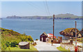
Ramsey Island from above St Justinian's Haven, 1994
by Ben Brooksbank geograph for square SM7225 View west across Ramsey Sound
|
|
St Justinian's Haven and Ramsey Island, 1994
by Ben Brooksbank geograph for square SM7225 View SW over the Ramsey Sound. No doubt the ferry was popular on a day such as this.
|
|
Pen Dal-Aderyn
by Alan Hughes geograph for square SM7123 Pen Dal-Aderyn - the most westerly point of mainland Wales - across the sound to... (more)
Tags:
top:CoastalX
top:Estuary, MarineX
subject:HeadlandX
top:IslandsX
Pen Dal-AderynX
place:Ramsey Island
Ramsey SoundX
top:Rocks, Scree, CliffsX
|
|
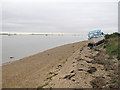
Ramsey Island Beach
by Roger Jones geograph for square TL9406 The "Lucky Star" rests on the beach at Ramsey Island, with the... (more)
Tags:
BeachX
river:BlackwaterX
BoatX
place:Dengie PeninsulaX
county:EssexX
top:Estuary, MarineX
place:Ramsey Island
top:Rivers, Streams, DrainageX
|
|
Carnllundain
by Rude Health geograph for square SM6923 Boat from St Justinian then a 3 TUMP island circuit on a sunny day, Carnysgubor,... (more)
|
|
The Bitches
by Philip Halling for square SM7023 The Bitches, a line of rock projecting out from Ramsey Island into Ramsey Sound,... (more)
Tags:
subject:CoastX
top:CoastalX
type:Cross GridX
Ramsey Island
RocksX
top:Rocks, Scree, CliffsX
The BitchesX
|
|
View to Ramsey Island
by Philip Halling geograph for square SM7123 View to Ramsey from the Pembrokeshire Coast Path above Pen Pedol.
|
|
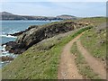
Pembroakeshire Coast Path above Pen Dal-aderyn
by Philip Halling geograph for square SM7123 Pembroakeshire Coast Path above Pen Dal-aderyn with Ramsey Island in the... (more)
Tags:
subject:CoastX
CoastX
top:CoastalX
type:GeographX
top:PathsX
Pembrokeshire CoastX
ldp:Pembrokeshire Coast PathX
Ramsey Island
|
|
Carnysgubor
by Rude Health geograph for square SM6924 Boat from St Justinian then a 3 TUMP island circuit on a sunny day, Carnysgubor,... (more)
Tags:
top:Barren PlateauxX
CarnysguborX
top:IslandsX
P51X
island:Ramsey Island
subject:SummitX
TumpX
top:UplandsX
|
|
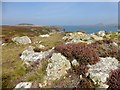
Ynys Gwelltog
by David Lally geograph for square SM7022 An impressive islet of Ramsey Island.
|
|
Cliffs by Porth Lleuog
by HelenK geograph for square SM6922 Porth Lleuog's name gives away that it is a poor quality harbour. It was... (more)
Tags:
BeachX
top:Docks, HarboursX
type:GeographX
former:HarbourX
top:IslandsX
place:Ramsey Island
top:Rocks, Scree, CliffsX
|
|
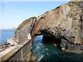
Natural Arch
by Rude Health geograph for square SM7023 A natural arch close to the quay where you land on Ramsey Island.
Tags:
top:CoastalX
top:IslandsX
Natural ArchX
subject:QuayX
island:Ramsey Island
top:Rocks, Scree, CliffsX
|
|
Ramsey Island east coast
by David Lally geograph for square SM7025 |
|
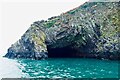
Ramsey Island cave
by David Lally geograph for square SM6924 Not sure if this is Ogof Tywood or Ogof Organ. The rock here is a metamorphic... (more)
|
|
Ramsey Island cliffs
by David Lally geograph for square SM7022 |
|
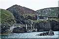
Ramsey Island landing
by David Lally geograph for square SM7023 |
|
Ramsey Island cave
by David Lally geograph for square SM7024 |
|
Ogof Hen bay
by HelenK geograph for square SM7025 The entrance to Ogof Hen itself (the 'old cave') is hidden behind the... (more)
|
|
Seals on Foel Fawr
by HelenK geograph for square SM7022 This is a popular resting place for the grey seals which are numerous around... (more)
|
|
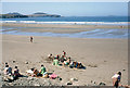
Sands being enjoyed at Whitesands Bay, 1968
by Ben Brooksbank geograph for square SM7327 View SW across Porth Mawr, to Ramsey Island, with to the right and farther away... (more)
Tags:
top:Air, Sky, WeatherX
top:CoastalX
top:IslandsX
Ramsey Island
top:Sport, LeisureX
Whitesands BayX
|
|
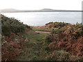
Narrow inlet on Ramsey Island
by David Lally geograph for square SM7024 Tags:
top:Estuary, MarineX
type:GeographX
subject:InletX
InletX
top:IslandsX
place:Ramsey Island
Rocky InletX
Sea InletX
|
|
Point St John and Penrhyn Dalar
by HelenK geograph for square SM7125 The section of the Pembrokeshire Coast Path which goes round the headland beyond... (more)
|
|
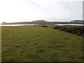
Looking towards the westernmost point
by HelenK geograph for square SM7123 This path connects with the Pembrokeshire Coast Path near Pen Dal-aderyn, the... (more)
Tags:
top:CoastalX
top:Farm, Fishery, Market GardeningX
type:GeographX
top:PathsX
long distance path:Pembrokeshire Coast PathX
island:Ramsey Island
place:St DavidsX
place:TreginnisX
|
|
A short stretch of the Pembrokeshire Coast Path
by HelenK geograph for square SM7124 Looking across the path with Ramsey Island in the distance. Very little of this... (more)
Tags:
top:CoastalX
type:GeographX
top:Heath, ScrubX
top:PathsX
long distance path:Pembrokeshire Coast PathX
island:Ramsey Island
place:St JustinianX
place:TreginnisX
|
|
Pen Pedol
by Alan Hughes geograph for square SM7123 Pen Pedol with Ynys Cantwr and southern tip of Ramsey Island in the background.
Tags:
top:CoastalX
top:Estuary, MarineX
subject:HeadlandX
long distance path:Pembrokeshire Coast PathX
Pen PedolX
place:Ramsey Island
|
|
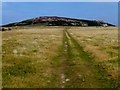
Track To The Bungalow
by Rude Health geograph for square SM7024 Track across Ramsay Island towards the Bungalow with a view towards Carnysgubor.
Tags:
CarnysguborX
top:GrasslandX
top:IslandsX
island:Ramsey Island
top:Roads, Road TransportX
The BungalowX
|
|
Port Lieuog
by David Lally geograph for square SM6923 With adult grey seals and their pups.
Tags:
Atlantic Grey SealsX
BeachX
subject:CoveX
type:GeographX
top:IslandsX
place:Ramsey Island
top:Wild Animals, Plants and MushroomsX
|
|
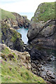
Cave under Ynys Cantwr
by David Lally for square SM7022 Our boat trip leader told a tale that the rock just left of centre was used by... (more)
|
|
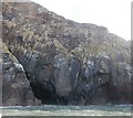
Ogof Colomennod
by HelenK geograph for square SM6923 These cliffs are home to numerous guillemots and some razorbills as well, which... (more)
Tags:
CaveX
bird:Common GuillemotX
type:GeographX
top:IslandsX
place:Ramsey Island
top:Rocks, Scree, CliffsX
|