Public Tags
Tag: Reigate·Lodge
Other tags: building:Reigate Lodge
Showing images tagged with Reigate Lodge tag.
|
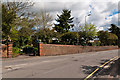
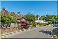
Church Street
by Ian Capper geograph for square TQ2550 These walls and gates originally belonged to Reigate Lodge, a large 18th century... (more)
Tags:
top:Housing, DwellingsX
Locally ListedX
place:ReigateX
Reigate CollegeX
Reigate Lodge
South WalkX
top:Suburb, Urban FringeX
WallX
|
|
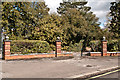
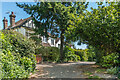
East Walk
by Ian Capper geograph for square TQ2550 This area was originally the grounds of Reigate Lodge, a large 18th century... (more)
Tags:
East WalkX
Locally ListedX
place:ReigateX
Reigate CollegeX
Reigate Lodge
top:Suburb, Urban FringeX
WallX
|
|
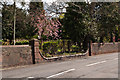
Church Street
by Ian Capper geograph for square TQ2550 This wall originally belonged to Reigate Lodge, a large 18th century mansion.... (more)
|
|
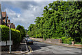
Croydon Road
by Ian Capper geograph for square TQ2550 Looking towards its junction with Church Street in the far distance.
The wall... (more)
|
|
Church Street
by Ian Capper geograph for square TQ2550 This wall (or at least the section on the left) originally belonged to Reigate... (more)
Tags:
top:Housing, DwellingsX
Locally ListedX
place:ReigateX
Reigate Lodge
South WalkX
top:Suburb, Urban FringeX
WallX
|
|
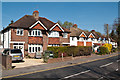
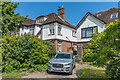
18 & 20 The Crescent
by Ian Capper geograph for square TQ2550 Houses in The Crescent, a road developed in the c.1920s following the demolition... (more)
Tags:
type:GeographX
top:Housing, DwellingsX
place:ReigateX
building:Reigate Lodge
top:Suburb, Urban FringeX
|
|
Rushworth Road
by Ian Capper geograph for square TQ2550 Built in the c.1920s on land that originally belonged to Reigate Lodge.
Tags:
top:Housing, DwellingsX
place:ReigateX
Reigate Lodge
Rushworth RoadX
top:Suburb, Urban FringeX
|
|
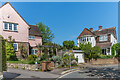
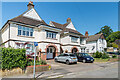
South Walk
by Ian Capper geograph for square TQ2550 Houses in South Walk, a road developed in the c.1920s following the demolition... (more)
Tags:
type:GeographX
top:Housing, DwellingsX
place:ReigateX
building:Reigate Lodge
road:South WalkX
top:Suburb, Urban FringeX
|
|
South Walk
by Ian Capper geograph for square TQ2550 Houses in South Walk, a road developed in the c.1920s following the demolition... (more)
Tags:
type:GeographX
top:Housing, DwellingsX
place:ReigateX
building:Reigate Lodge
road:South WalkX
top:Suburb, Urban FringeX
|
|
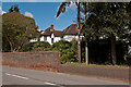
Chart Way
by Ian Capper geograph for square TQ2550 Houses in Chart Way, a road developed in the c.1920s following the demolition of... (more)
Tags:
road:Chart WayX
type:GeographX
top:Housing, DwellingsX
place:ReigateX
building:Reigate Lodge
top:Suburb, Urban FringeX
|
|
4 & 6 Chart Way
by Ian Capper geograph for square TQ2550 Pair of houses in Chart Way, a road developed in the c.1920s following the... (more)
Tags:
road:Chart WayX
type:GeographX
top:Housing, DwellingsX
place:ReigateX
building:Reigate Lodge
top:Suburb, Urban FringeX
|