Public Tags
Tag: Rothbury
Showing latest 50 of 143 images tagged with Rothbury tag.

|
Temporary road bridge, Rothbury
by Rose and Trev Clough geograph for square NU0501 The Bailey bridge on the left was put up in 2010... (more)
Tags:
Bridge MaintenanceX
top:Roads, Road TransportX
place:Rothbury
bridge:Rothbury BridgeX
Temporary BridgeX
|
|
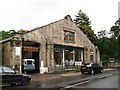
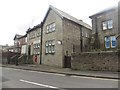
Rothbury Garage
by Rose and Trev Clough geograph for square NU0501 Built in 1913, when only rich people had motor cars, the building has changed... (more)
|
|
The Jubilee Institute, Rothbury
by Rose and Trev Clough geograph for square NU0501 Also known as Jubilee Hall, it is a community centre with a number of rooms,... (more)
|
|
Rothbury Community Hospital
by Graham Robson geograph for square NU0501 Looking across the River Coquet towards the small hospital which serves the... (more)
|
|
Public toilets, Rothbury
by Graham Robson geograph for square NU0501 The town centre public toilets in Rothbury, set back from the street and... (more)
|
|
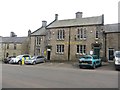
Library, arts centre and police station, Rothbury
by Graham Robson geograph for square NU0501 A public building on High Street in Rothbury in which a number of public... (more)
|
|
Rothbury Post Office
by Graham Robson geograph for square NU0501 The Post Office serving the community in the town of Rothbury.
|
|
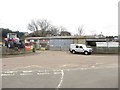
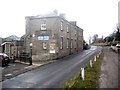
Agricultural engineers, Rothbury
by Graham Robson geograph for square NU0601 An independent engineering business on the small industrial estate in Rothbury.... (more)
|
|
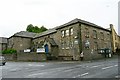
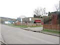
Rothbury Fire Station
by Graham Robson geograph for square NU0601 The small fire station from which Rothbury and the surrounding area is covered.
|
|
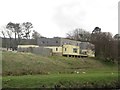
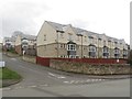
Martfield, Rothbury
by Graham Robson geograph for square NU0601 A modern housing development of 3 storey houses in Rothbury.
|
|
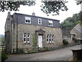
Rothbury House
by Stanley Howe geograph for square NU0501 A RAF Association clubhouse on Rothbury High Street.
|
|
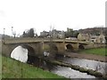
Rothbury Bridge
by Graham Robson geograph for square NU0501 Looking at Rothbury Bridge which provides the only vehicular access across the... (more)
Tags:
river:CoquetX
top:Historic Sites and ArtefactsX
top:Rivers, Streams, DrainageX
Road BridgeX
top:Roads, Road TransportX
place:Rothbury
|
|
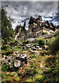
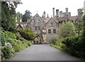
Cragside House
by Andy Stephenson geograph for square NU0702 Cragside's house and estate was created by a remarkable couple, Lord... (more)
Tags:
top:Country EstatesX
place:CragsideX
CragsideX
Cragside RothburyX
type:GeographX
subject:Historic BuildingX
person:Lord ArmstrongX
National TrustX
National Trust GardenX
National Trust PropertiesX
National Trust SiteX
architect:Norman ShawX
place:NorthumberlandX
top:Park and Public GardensX
top:Rocks, Scree, CliffsX
near:Rothbury
Rothbury
person:William ArmstrongX
|
|
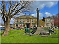
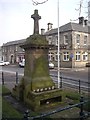
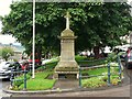
Rothbury Cross
by Graham Hogg geograph for square NU0501 This monument was erected in the year 1902 on the site of the ancient market... (more)
Tags:
subject:CrossX
type:GeographX
top:People, EventsX
place:Rothbury
top:Village, Rural SettlementX
|
|
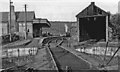
Rothbury station, 1953
by Walter Dendy, deceased geograph for square NU0601 View east, towards Scotsgap and Morpeth. This was the terminus of the branch... (more)
|
|
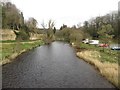
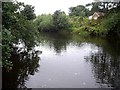
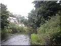
View downstream along the River Coquet, Rothbury
by Graham Robson geograph for square NU0501 Looking downstream along the River Coquet from the centre of the footbridge... (more)
|
|
Footpath beside the River Coquet
by Graham Robson geograph for square NU0401 Looking along the footpath which follows the river bank upstream from the centre... (more)
|
|
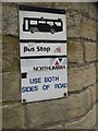
Old bus stop sign, Rothbury
by Graham Robson for square NU0501 An old bus stop sign attached to a retaining wall on the side of High Street.... (more)
|
|
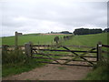
Shut the gate!
by Stanley Howe geograph for square NT9901 A 5-bar wooden gate on the public pathway between Caistron and Low Farnham,... (more)
|
|
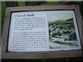
All Saints Churchyards, Rothbury
by Stanley Howe for square NU0501 An information panel about the churchyards and some notable graves.
|
|
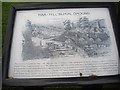
'Haa-Hill' burial ground, Rothbury
by Stanley Howe for square NU0501 Information panel off 'The Haw'.
|
|
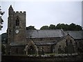
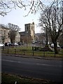
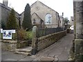
All Saints Church, Rothbury
by Stanley Howe geograph for square NU0501 Seen over the churchyard wall from The Haw.
|
|
Upstream River Coquet, Rothbury
by Stanley Howe geograph for square NU0601 From the stepping stones.
Tags:
river:CoquetX
top:Rivers, Streams, DrainageX
place:Rothbury
Stepping StonesX
looking:UpstreamX
|
|
Downstream River Coquet, Rothbury
by Stanley Howe geograph for square NU0601 From the stepping stones.
Tags:
river:CoquetX
looking:DownstreamX
top:Rivers, Streams, DrainageX
place:Rothbury
Stepping StonesX
|
|
Foot of Mart Bank, Rothbury
by Stanley Howe geograph for square NU0601 |
|
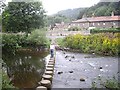
Stepping Stones, Rothbury
by Stanley Howe geograph for square NU0601 Across the River Coquet. The stones have been reset since 2012 LINK.
|
|
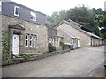
House by the Mart, Rothbury
by Stanley Howe geograph for square NU0601 |
|
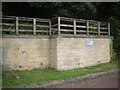
One-way exit from Cragside estate onto the Alnwick Road (B6341)
by Stanley Howe geograph for square NU0603 The B6341 from Rothbury leads to Alnwick, Morpeth and Newcastle.
|
|
Cragend Farm (2013), Rothbury
by Stanley Howe geograph for square NU0800 As seen from a Cragside Estate road; substantial repair work seems to be in... (more)
|
|
Approach to Cragside House, Rothbury
by Stanley Howe geograph for square NU0702 The arch ahead affords vehicular access for visitors to the 1000 acre estate.
|
|
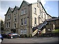
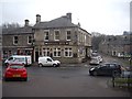
Coquetvale Hotel, Rothbury
by Stanley Howe geograph for square NU0601 On Station Road (B6342).
|
|
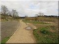
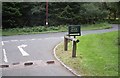
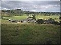
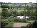
An elevated viewpoint, Rothbury
by Stanley Howe for square NU0501 In the car park for the Coquet riverside walk, and offering a panoramic view of... (more)
|
|
Access to the Coquet riverside path
by Stanley Howe geograph for square NU0501 From a car park off the B6341, just west of Rothbury.
|
|
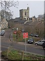
Parish Church, Rothbury
by Stanley Howe geograph for square NU0501 The clock tower of All Saints viewed from the High Street.
Tags:
Anglican ChurchX
ClocktowerX
top:Religious SitesX
place:Rothbury
top:Village, Rural SettlementX
|
|
All Saints Parish Church, Rothbury (circa 1650)
by Stanley Howe geograph for square NU0501 A Market Cross (aka St Armstrong's Cross - in the foreground) was... (more)
Tags:
Anglican ChurchX
Market CrossX
top:Religious SitesX
place:Rothbury
top:Village, Rural SettlementX
|
|
War Memorial, Rothbury
by Stanley Howe geograph for square NU0501 Honouring 31 men of the parish who lost their lives in WW2 1939-1945; plus one... (more)
|
|
A High Street pharmacy
by Stanley Howe geograph for square NU0501 Boots in Rothbury.
Tags:
Boots PharmacyX
top:Business, Retail, ServicesX
street:High StreetX
place:Rothbury
top:Village, Rural SettlementX
|
|
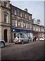
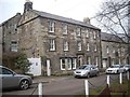
Triple storey house on the High Street
by Stanley Howe geograph for square NU0501 Rothbury.
Tags:
street:High StreetX
HouseX
top:Housing, DwellingsX
place:Rothbury
top:Village, Rural SettlementX
|
|
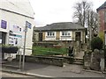
Community Gallery, Rothbury
by Stanley Howe geograph for square NU0501 On the High Street.
|
|
Library and Arts Centre, Rothbury
by Stanley Howe geograph for square NU0501 On Front Street; viewed from the High Street.
Tags:
Arts CentreX
LibraryX
top:Public Buildings and SpacesX
place:Rothbury
StreetX
top:Village, Rural SettlementX
|
|
Rothbury 'Fish and Chips'
by Stanley Howe geograph for square NU0501 Fish and Chip Shop on the High Street.
Tags:
top:Business, Retail, ServicesX
Fish and Chip ShopX
street:High StreetX
place:Rothbury
top:Village, Rural SettlementX
|
|
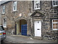
Arched access to Ogle House
by Stanley Howe for square NU0501 From the High Street, Rothbury.
|
|
The Turks Head
by Stanley Howe geograph for square NU0501 Inn and Plan 'C' restaurant on the High Street in Rothbury.
Tags:
top:Business, Retail, ServicesX
street:High StreetX
InnX
RestaurantX
place:Rothbury
top:Village, Rural SettlementX
|
|
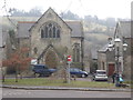
United Reformed Church, Rothbury
by Stanley Howe geograph for square NU0501 A view across Front Street from the High Street.
Tags:
top:Religious SitesX
place:Rothbury
StreetX
church:United ReformedX
top:Village, Rural SettlementX
|
|
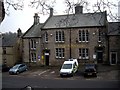
Newcastle Hotel, Rothbury
by Stanley Howe geograph for square NU0501 At the junction of Church Street with Front Street.
|
|
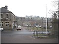
Town Square, Rothbury
by Stanley Howe geograph for square NU0501 Newcastle Hotel on left, Celtic Cross and War Memorial on the right.
|
|
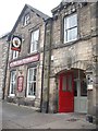
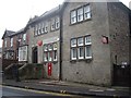
Rothbury Post Office
by Stanley Howe geograph for square NU0501 On Bridge Street.
|
|
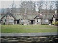
Alms Houses by Town Foot, Rothbury
by Stanley Howe geograph for square NU0601 Ranged horseshoe style around three sides of a communal lawn in the east end of town.
|
|
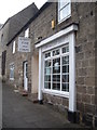
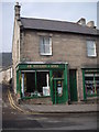
Corner of Providence Lane and Town Foot, Rothbury
by Stanley Howe geograph for square NU0501 The toyshop of J.R.Soulby and Son, showing both an 'OPEN' sign in the... (more)
Tags:
top:Roads, Road TransportX
place:Rothbury
Street JunctionX
ToyshopX
top:Village, Rural SettlementX
|
|
Rothbury war memorial
by Rose and Trev Clough geograph for square NU0501 "To the memory of those of this parish who gave their lives for their... (more)
|