Public Tags
Tag: Skerry
Showing latest 50 of 510 images tagged with Skerry tag.
|
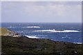
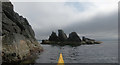
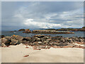
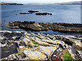
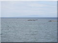
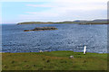
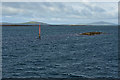
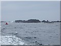
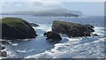
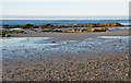
Inner Skerry and West Skerry
by David Dixon for square HU3633 Two small, rocky islets of the coast of West Burra. The skerry nearest to the... (more)
Tags:
Atlantic OceanX
top:CoastalX
type:Cross GridX
IslandX
top:IslandsX
IsletX
camera:Panasonic Lumix TZ60X
Shetland IslandsX
Skerry
|
|
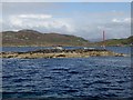
Burki Skerries
by Andy Waddington geograph for square HU3162 Category: Skerry The foreground bay, Bungil, has a few skerries or stacks, but Burki Skerries... (more)
|
|
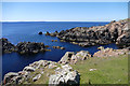
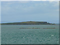
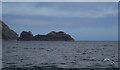
Skerry off Eilean nam Meann, Lismore
by Michael Jagger geograph for square NM8746 Category: Skerry Skerry is just North of Eilean nam Meann, the outer skerry is to the right of... (more)
Tags:
top:Air, Sky, WeatherX
top:CoastalX
Eilean Nam MeannX
top:Estuary, MarineX
top:IslandsX
LismoreX
Loch LinnheX
PerchX
ReefX
Reef MarkerX
Skerry
top:Water ResourcesX
top:Wild Animals, Plants and MushroomsX
|
|
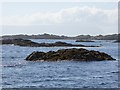
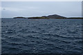
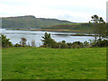
Skerries in Crossapol Bay, Coll
by eswales geograph for square NM1252 Category: Skerry Looking northeastwards over some of the more westerly skerries and rocks in... (more)
|
|
Skerry off Kame
by Andy Waddington geograph for square HU3343 Category: Skerry This is the final outcrop of Walls Formation of Middle Old Red Sandstone... (more)
|
|
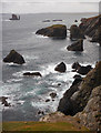
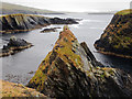
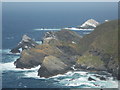
Skerries off the SW coast of Muckle Roe
by Andy Waddington geograph for square HU3063 Category: Promontory The coast of Muckle Roe has so many stacks, skerries, promontories and other... (more)
Tags:
top:CoastalX
top:Estuary, MarineX
type:GeographX
category:PromontoryX
top:Rocks, Scree, CliffsX
category:Skerry
|
|
Nista Skerries
by Andy Waddington geograph for square HU2777 Category: Skerry The skerries peek out of the waves of Sand Wick, the bay on the west of the... (more)
|
|
Isle of Niddister and Windy Geo
by Andy Waddington geograph for square HU2775 Category: Skerry Below the cliffs of the Ness of Hillswick lies a fantastic playground of stacks... (more)
|
|
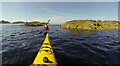
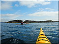
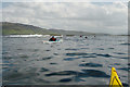
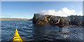
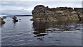
Threading skerries west of Erraid
by Andy Waddington geograph for square NM2820 Category: Skerry On a trip collecting skerries around Erraid, we soon reached this pair west of... (more)
Tags:
top:CoastalX
top:Estuary, MarineX
type:GeographX
top:IslandsX
top:Rocks, Scree, CliffsX
category:Sea KayakingX
category:Skerry
top:Sport, LeisureX
|
|
|
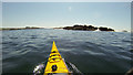
Unnamed Skerry west of Eilean nam Muc
by Andy Waddington geograph for square NM2719 Category: Skerry Another day, another paddling trip visiting small bits of rock in the sea. We... (more)
|
|
Arisaig skerries
by Oliver Dixon geograph for square NM6185 The South Channel at the entrance to Loch nam Ceall is dotted with numerous... (more)
|
|
Skerries off Am Fraoch-eilean
by Oliver Dixon geograph for square NM6185 Numerous skerries in the South Channel of Loch nam Ceall.
|
|
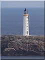
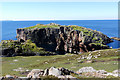
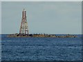
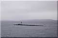
Out Skerries: Bound Skerry lighthouse
by Chris Downer for square HU7071 The lighthouse stands on Bound Skerry, the easternmost piece of land in Scotland.
|
|
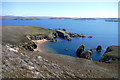
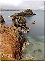
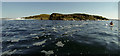
Eilean Dubh na Ciste
by Andy Waddington geograph for square NM3025 Category: Skerry Eilean Dubh na Ciste is a rocky skerry at the NNE end of Bull Hole, a narrow... (more)
|
|
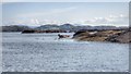
Tidal skerry off Ynys Llanddwyn
by Andy Waddington geograph for square SH3962 Category: Skerry This rock is a skerry at high tide, but since it is now near low water, it is... (more)
|
|
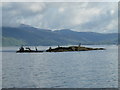
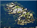
Seals hauled out on a skerry in Loch Dunvegan
by Andy Waddington geograph for square NG2449 Category: Skerry Paddling out from a launch about a kilometre north of Dunvegan Castle, we... (more)
|
|
Nesting on a pointy skerry
by Andy Waddington geograph for square HU3620 Category: Skerry There seem to be Fulmars nesting on almost every cliff or ledge in most parts of... (more)
|
|
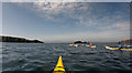
Arriving at Lunga Skerries
by Andy Waddington geograph for square HU3442 Category: Sea kayaking Linking the scattered skerries from North Score Holm down to Hildasay makes all... (more)
Tags:
top:CoastalX
top:Estuary, MarineX
type:GeographX
top:IslandsX
top:Rocks, Scree, CliffsX
category:Sea KayakingX
category:Skerry
|
|
Black Skerry of Houlma Sound
by Andy Waddington geograph for square HU2676 Category: Sea kayaking On an anticlockwise circuit of the Ness of Hillswick, visiting the Drongs,... (more)
Tags:
top:CoastalX
top:Estuary, MarineX
type:GeographX
top:IslandsX
top:Rocks, Scree, CliffsX
category:Sea KayakingX
category:Skerry
top:Sport, LeisureX
|
|
One of the Murbie Stacks
by Andy Waddington geograph for square HU3062 Category: Skerry The Murbie Stacks are not what most of us would think of as stacks - tall,... (more)
|
|
Stack of Niddister
by Andy Waddington geograph for square HU2875 Category: Skerry The Stack of Niddister (seen here from a peninsula which juts out southeast into... (more)
|
|
Skerries on east side of Ness of Sound
by Andy Waddington geograph for square HU4739 Category: Skerry The gently dipping Middle Old Red Sandstone of east Mainland produces skerries... (more)
|
|
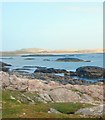
Skerries north of Little Colonsay
by Andy Waddington geograph for square NM3737 Category: Skerry We've paddled across from Staffa in quite a big swell, and have managed to... (more)
Tags:
top:CoastalX
top:Estuary, MarineX
type:GeographX
top:IslandsX
category:Sea KayakingX
category:Skerry
top:Sport, LeisureX
|
|
The Dubh Sgeir south of Erraid
by Andy Waddington geograph for square NM2718 Category: Skerry I find myself visiting a lot of "black skerry" locations in my search... (more)
Tags:
top:CoastalX
top:Estuary, MarineX
type:GeographX
top:IslandsX
top:Rocks, Scree, CliffsX
category:Sea KayakingX
category:Skerry
top:Sport, LeisureX
|
|
Unnamed skerry south of Erraid
by Andy Waddington geograph for square NM2918 Category: Skerry With a metre or so of swell, the waves were breaking well over the south side of... (more)
Tags:
top:CoastalX
top:Estuary, MarineX
type:GeographX
top:IslandsX
top:Rocks, Scree, CliffsX
category:Sea KayakingX
category:Skerry
top:Sport, LeisureX
|
|
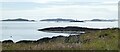
Skerries in the Sound of Harris
by M J Richardson geograph for square NF9879 Looking southeast from the ferry en route from Harris to Berneray.
Tags:
top:CoastalX
top:Estuary, MarineX
type:GeographX
Na H-Eileanan an Iar/Outer HebridesX
top:Rocks, Scree, CliffsX
SkerriesX
subject:SkerryX
Sound of Harris/Caolas Na HearadhX
|
|
Halliman Skerries
by Oliver Dixon for square NJ2172 Skerry off-shore from Lossiemouth West Beach seen at half-tide. Numerous... (more)
Tags:
BeaconX
top:CoastalX
type:Cross GridX
top:Docks, HarboursX
top:Rocks, Scree, CliffsX
SeabirdsX
subject:SkerryX
Skerry
top:Wild Animals, Plants and MushroomsX
|

|
Skerry of Wastbist, Westray Firth
by George Brown geograph for square HY4841 Skerry of Wastbist with Twiness Farm buildings on Westray. The skerry is home to... (more)
|
|
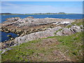
Looking to the Sound of Iona from Torr Gaineamhach
by Andy Waddington geograph for square NM2921 Category: Skerry Where the Ross of Mull granite has few joints, it weathers into Tors, often... (more)
|
|
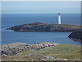
Out Skerries: Bound Skerry from Bruray Ward
by Chris Downer for square HU7071 Looking down from the top of Bruray Ward towards the lighthouse on the... (more)
|
|
Black and White
by Des Blenkinsopp geograph for square HU5285 Black Skerry rocks and The White Wife monument.
Pushing my luck a bit on the... (more)
|
|
Eastern tip of Sgeir nam Biast
by Andy Waddington geograph for square NG2356 Category: Skerry About 40% of the way from a landing on Iosaigh to our take-out at Stein, Sgeir... (more)
|
|
Càrn nan Sgeir
by Oliver Dixon for square NC0101 With the smaller skerry of Meall nan Caorach to the right. Beyond is the... (more)
|
|
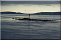
Skerry of Vasa
by Richard Webb geograph for square HY4618 A skerry and beacon off Shapinsay.
|
|
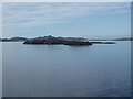
Un-named skerry
by Mick Garratt geograph for square NG0080 |
|
Skerry north off Lingeigh-Fhada
by Mick Garratt geograph for square NF7204 |
|
An Cannunn
by Mick Garratt geograph for square NG7874 A small skerry off Eilean Horrisdale.
|
|
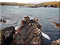
Seals on a Skerry in North Channel
by Mick Garratt geograph for square NM6387 |
|
Dubh Sgeir
by Oliver Dixon geograph for square NM4278 Skerries on the west side of the channel into Port Mor. A buoy marks the way.
|
|
Sgeir Mhurchaidh
by Oliver Dixon geograph for square NM6285 Tidal skerry in Loch na Ceall with navigation marker.
|
|
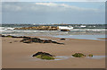
Skerries off the south coast of Jura.
by Oliver Dixon geograph for square NR4563 Beyond is the island of Am Fraoch Eilean NR4662 topped by Claig Castle.
|
|
An Cleiteadh
by Oliver Dixon geograph for square NM7513 Skerry off the east coast of Luing. Beyond the channel, the flat land is at the... (more)
|
|
Coar Holm
by Richard Webb geograph for square HU3620 View past skerries (Skeetsa Skerry, left; Coar Holm centre) towards Fitful Head.
|
|
Skerry of Vasa
by Bill Boaden geograph for square HY4618 The lighting has become stark, with rain showers massing to the south. Just in... (more)
|
|
Herma Ness: stacks below Hermaness Hill
by Chris Downer for square HP5917 Looking north alongside the cliffs of Hermaness Hill, with the various stacks... (more)
|
|
Looking Towards Halliman Skerries
by Anne Burgess geograph for square NJ2071 The foreground is all in square but the beacon on Halliman Skerries is in an... (more)
|
|
Covesea Skerries from Covesea Beach
by Anne Burgess geograph for square NJ1971 At the far edge of the square are the Covesea Skerries, a dangerous outcrop... (more)
|
|
St Kilda - Sgarbhstac
by Rob Farrow for square NA1504 Sgarbhstac is a small islet or skerry off the southwestern coast of Boreray in... (more)
|
|
A skerry where a herd of sun-drenched seals laze in a leisurely respite
by Mick Garratt for square NG2365 |
|
Luing - View to Dubh Sgeir and islands beyond
by Rob Farrow for square NM7212 The island with the beacon at mid distance is NM7212 : Dubh Sgeir. Behind this lined... (more)
|