Geograph - photograph every grid square
About tags on Geograph
Tags
Geographical Context
Subjects
Types
Other Prefixes
Public Tags
Related Tags
|
Coverage Map
Tag:
Stillingfleet
Other tags:
place:
Stillingfleet
Showing images tagged with
Stillingfleet
tag.
View all tagged images
-
In Browser
Search within these images
:
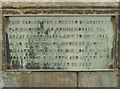
Sign on Stillingfleet Bridge
by
Graham Hogg
for square
SE5940
Commemorating a flood in 1947 and, unusually, thanking the owner and crew of a... (
more
)
Tags:
type:
Close Look
X
top:
Rivers, Streams, Drainage
X
subject:
Sign
X
place:
Stillingfleet
Stillingfleet Beck
X
top:
Village, Rural Settlement
X
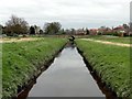
Stillingfleet Beck
by
Graham Hogg
geograph for square
SE5940
See
SE5940 : Sign on Stillingfleet Bridge
for an unusual sign on the bridge
Tags:
type:
Geograph
X
top:
Rivers, Streams, Drainage
X
place:
Stillingfleet
Stillingfleet Beck
X
subject:
Stream
X
top:
Village, Rural Settlement
X
Footbridge in the village green
by
Graham Hogg
geograph for square
SE5940
The bridge carries a footpath over Stillingfleet Beck
Tags:
subject:
Bridge
X
type:
Geograph
X
top:
Paths
X
top:
Rivers, Streams, Drainage
X
place:
Stillingfleet
Stillingfleet Beck
X
Village Green
X
top:
Village, Rural Settlement
X
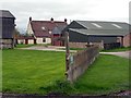
The former entrance to Stillingfleet coal mine
by
Steve Fareham
geograph for square
SE5941
Now according to the signs a practice area for prison guard dogs.
Tags:
Former Coal Mine
X
top:
Roads, Road Transport
X
Stillingfleet
top:
Village, Rural Settlement
X
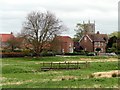
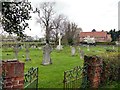
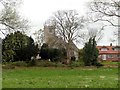
Stillingfleet Cemetery
by
Graham Hogg
geograph for square
SE5941
An extension to the graveyard at St Helen's Church
Tags:
top:
Burial Ground, Crematorium
X
subject:
Cemetery
X
Cemetery
X
type:
Geograph
X
place:
Stillingfleet
top:
Village, Rural Settlement
X
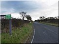
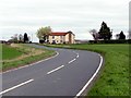
A bend in the road
by
Graham Hogg
geograph for square
SE5840
The B1222 between Kelfield and Stillingfleet
Tags:
type:
Geograph
X
subject:
Road
X
top:
Roads, Road Transport
X
place:
Stillingfleet
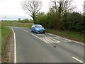
In the middle of a double bend
by
Graham Hogg
geograph for square
SE5739
The B1222 between Kelfield and Stillingfleet
Tags:
type:
Geograph
X
subject:
Road
X
top:
Roads, Road Transport
X
place:
Stillingfleet
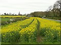
A roadside strip of oilseed rape
by
Graham Hogg
geograph for square
SE6039
Possibly just wide enough to be efficiently harvested by machine
Tags:
subject:
Crop
X
top:
Farm, Fishery, Market Gardening
X
type:
Geograph
X
Oilseed Rape
X
top:
Roads, Road Transport
X
place:
Stillingfleet
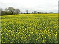
Field of oilseed rape in flower
by
Graham Hogg
geograph for square
SE6040
Tags:
subject:
Crop
X
top:
Farm, Fishery, Market Gardening
X
type:
Geograph
X
Oilseed Rape
X
place:
Stillingfleet
St Helen's Church
by
Graham Hogg
geograph for square
SE5940
Tags:
subject:
Church
X
type:
Geograph
X
top:
Religious Sites
X
place:
Stillingfleet
top:
Village, Rural Settlement
X
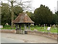
Lych gate at St Helen's Church
by
Graham Hogg
geograph for square
SE5940
Tags:
Church
X
subject:
Gate
X
type:
Geograph
X
Graveyard
X
Lych Gate
X
top:
Paths
X
top:
Religious Sites
X
place:
Stillingfleet
top:
Village, Rural Settlement
X
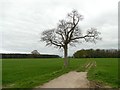
Winter tree beside a bridleway
by
Graham Hogg
geograph for square
SE5841
Tags:
Bridleway
X
top:
Farm, Fishery, Market Gardening
X
type:
Geograph
X
top:
Grassland
X
top:
Paths
X
place:
Stillingfleet
subject:
Tree
X
Kelfield Grange Farm
by
Graham Hogg
geograph for square
SE5839
Here a bridleway runs a short distance to the east before terminating in a small wood
Tags:
Bridleway Signpost
X
subject:
Farm
X
top:
Farm, Fishery, Market Gardening
X
type:
Geograph
X
place:
Stillingfleet
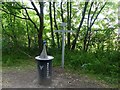
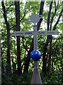
Neptune
by
Graham Hogg
geograph for square
SE6141
Part of the solar system model laid out on the cycle route between York and... (
more
)
Tags:
top:
Educational Sites
X
type:
Geograph
X
subject:
Model
X
National Cycle Network
X
top:
Paths
X
top:
Sport, Leisure
X
place:
Stillingfleet
Trans Pennine Trail
X
Neptune
by
Graham Hogg
for square
SE6141
Part of the solar system model laid out on the cycle route between York and... (
more
)
Tags:
type:
Close Look
X
top:
Educational Sites
X
subject:
Model
X
National Cycle Network
X
top:
Paths
X
top:
Sport, Leisure
X
place:
Stillingfleet
Trans Pennine Trail
X
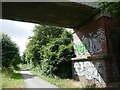
Graffiti on a bridge abutment
by
Graham Hogg
geograph for square
SE6140
The bridge carries a farm track over the Trans Pennine Trail cycle route, which... (
more
)
Tags:
subject:
Bridge
X
type:
Geograph
X
National Cycle Network
X
top:
Paths
X
top:
Sport, Leisure
X
place:
Stillingfleet
Trans Pennine Trail
X
View more in the Image Search
or
in Browser
View images matching 'Stillingfleet' anywhere
in
the tags
Don't click these:
PotMel 1
PotMel 2
☰
Home
View
Search
Marked Images
Maps
Browser
Explore
Showcase
New Images
Collections
Interact
Games
Discussions
Blog
Contributors
Submit
Statistics
Leaderboards
General
FAQ
Help Pages
Sitemap
Contact Us
Support Us
sponsored by
🔍
What to search:
Photos
Enter keywords or a location/postcode to search nearby images
Enter a Grid Reference
Placenames
Collections
Website Pages
Everything
Others:
Advanced Search
|
Image Browser
Or:
Coverage Map
|
Searchable Map
You are not logged in
login
|
register